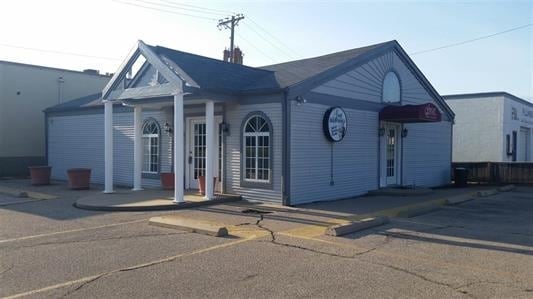
Property Record
639 N Walnut St, Augusta, KS 67010
NEARBY LISTINGS FOR SALE OR LEASE
Property Detail
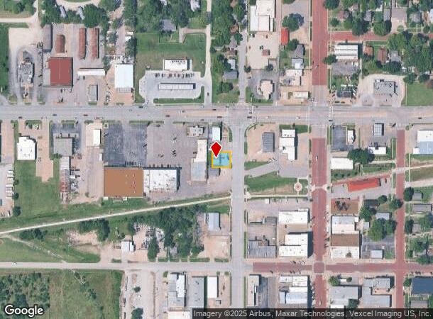
639 N Walnut St
Wichita, KS
Augusta, Original Town
298-27-0-10-05-002-00-0
AUGUSTA, ORIG TOWN, S27, T27, R04E, E80.5 LT 9; S15 E80.5 LT 10 BLK 23
Warehouse
Butler
X
Kansas
20015C0511F
9-10
2024
0.12 AC
2025
Augusta/El Dorado
020800
Wichita
1,200 SF
DEMOGRAPHICS near 639 N Walnut St
1 Mile
3 Mile
5 Mile
2024 Total Population
4,598
10,047
12,452
2029 Population
4,738
10,264
12,711
Pop Growth 2024-2029
+ 3.04%
+ 2.16%
+ 2.08%
Average Age
38
40
41
2024 Total Households
1,915
3,989
4,882
HH Growth 2024-2029
+ 3.08%
+ 2.23%
+ 2.15%
Median Household Inc
$45,235
$53,890
$60,205
Avg Household Size
2.30
2.40
2.50
2024 Avg HH Vehicles
2.00
2.00
2.00
Median Home Value
$95,635
$156,111
$174,037
Median Year Built
1957
1973
1976
Nearby Places
Map Layers
Map Styles
 Street
 Aerial
- Restaurants
- Banks
- Shops
- Fitness
- Groceries
PUBLIC TRANSPORTATION
AIRPORT
Wichita Dwight D Eisenhower Ntl
DRIVE
WALK
Distance
Wichita Dwight D Eisenhower Ntl
32 min
26.0 mi
Nearby Properties
Address
Land Use
TOTAL SIZE
Lot Size
Zoning
Address
Land Use
TOTAL SIZE
Lot Size
Zoning
5.10 AC
Address
Land Use
TOTAL SIZE
Lot Size
Zoning
42.50 AC
Address
Land Use
TOTAL SIZE
Lot Size
Zoning
Address
Land Use
TOTAL SIZE
Lot Size
Zoning
28,587 SF
5 AC
Address
Land Use
TOTAL SIZE
Lot Size
Zoning
20.90 AC
Address
Land Use
TOTAL SIZE
Lot Size
Zoning
4.80 AC
Address
Land Use
TOTAL SIZE
Lot Size
Zoning
45,938 SF
5 AC
Address
Land Use
TOTAL SIZE
Lot Size
Zoning
8.40 AC
Address
Land Use
TOTAL SIZE
Lot Size
Zoning
32,876 SF
1.40 AC
Address
Land Use
TOTAL SIZE
Lot Size
Zoning
6.50 AC
Address
Land Use
TOTAL SIZE
Lot Size
Zoning
3.30 AC
Address
Land Use
TOTAL SIZE
Lot Size
Zoning
15,136 SF
10.10 AC
Address
Land Use
TOTAL SIZE
Lot Size
Zoning
120,432 SF
15 AC
Address
Land Use
TOTAL SIZE
Lot Size
Zoning
3.20 AC
Address
Land Use
TOTAL SIZE
Lot Size
Zoning
3,000 SF
6.30 AC
Address
Land Use
TOTAL SIZE
Lot Size
Zoning
2,804 SF
3.70 AC
Address
Land Use
TOTAL SIZE
Lot Size
Zoning
213.40 AC
Address
Land Use
TOTAL SIZE
Lot Size
Zoning
32,047 SF
1.10 AC
Address
Land Use
TOTAL SIZE
Lot Size
Zoning
Address
Land Use
TOTAL SIZE
Lot Size
Zoning
12.30 AC
Address
Land Use
TOTAL SIZE
Lot Size
Zoning
0.90 AC
Address
Land Use
TOTAL SIZE
Lot Size
Zoning
4,743 SF
0.99 AC
Address
Land Use
TOTAL SIZE
Lot Size
Zoning
40,670 SF
5.20 AC
Address
Land Use
TOTAL SIZE
Lot Size
Zoning
1,440 SF
34 AC
Address
Land Use
TOTAL SIZE
Lot Size
Zoning
6.10 AC
Address
Land Use
TOTAL SIZE
Lot Size
Zoning
6.40 AC
Address
Land Use
TOTAL SIZE
Lot Size
Zoning
1,457 SF
6 AC
Address
Land Use
TOTAL SIZE
Lot Size
Zoning
12,342 SF
5.30 AC
Address
Land Use
TOTAL SIZE
Lot Size
Zoning
74,656 SF
2.60 AC
Address
Land Use
TOTAL SIZE
Lot Size
Zoning
16,359 SF
0.76 AC
The World's #1 Commercial Real Estate Marketplace
Connect with us
© 2025 CoStar Group
The information above has been obtained from sources believed reliable. While we do not doubt its accuracy we have not verified it and make no guarantee, warranty or representation about it. It is your responsibility to independently confirm its accuracy and completeness. Any projections, opinions, assumptions, or estimates used are for example only and do not represent the current or future performance of the property. The value of this transaction to you depends on tax and other factors which should be evaluated by your tax, financial, and legal advisors. You and your advisors should conduct a careful, independent investigation of the property to determine to your satisfaction the suitability of the property for your needs.