Property Record
639 Phillips Rd, Webster, NY 14580
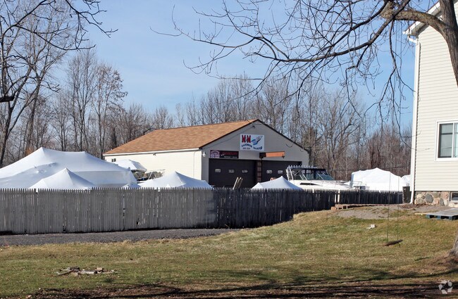

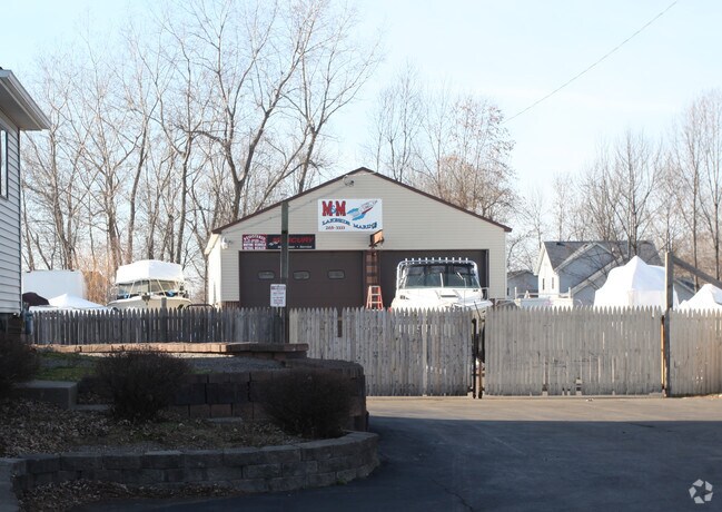
Property Detail
639 Phillips Rd
265489 065.03-1-2.1
0007-14-04
Warehouse
Monroe
06 - INDUS
New York
B and X Area of moderate flood hazard, usually the area between the limits of the 100-year and 500-year floods.
2.100
2025
2.57 AC
2025
Northeast
011302
Rochester
1,800 SF
Rochester, NY
NEARBY LISTINGS FOR SALE OR LEASE
DEMOGRAPHICS near 639 Phillips Rd
1 mile
3 mile
5 mile
2025 Total Population
2,944
30,616
55,166
2030 Population
2,941
30,551
54,784
Pop Growth 2025-2030
(0.10%)
(0.21%)
(0.69%)
Average Age
45
44
44
2025 Total Households
1,110
12,997
22,833
HH Growth 2025-2030
(0.09%)
(0.29%)
(0.75%)
Median Household Inc
$126,520
$90,575
$98,640
Avg Household Size
2.60
2.30
2.40
2025 Avg HH Vehicles
2.00
2.00
2.00
Median Home Value
$318,939
$292,424
$287,546
Median Year Built
1987
1986
1985
Nearby Places
Map Layers
Map Styles
 Street
 Aerial
Layers
 Traffic
 Biking
Places
Listings with unknown addresses are not visible on the map
- Restaurants
- Banks
- Shops
- Fitness
- Groceries
PUBLIC TRANSPORTATION
AIRPORT
Frederick Douglass/Greater Rochester International
Drive
Walk
Distance
Frederick Douglass/Greater Rochester International
30 min
18.3 mi
Nearby Properties
Address
Land Use
TOTAL SIZE
Lot Size
Zoning
Address
Land Use
TOTAL SIZE
Lot Size
Zoning
120,974 SF
42.70 AC
06
Address
Land Use
TOTAL SIZE
Lot Size
Zoning
39.21 AC
Address
Land Use
TOTAL SIZE
Lot Size
Zoning
9,383 SF
37.70 AC
Address
Land Use
TOTAL SIZE
Lot Size
Zoning
78,944 SF
379.99 AC
06 - INDUS
Address
Land Use
TOTAL SIZE
Lot Size
Zoning
78,944 SF
379.99 AC
06 - INDUS
Address
Land Use
TOTAL SIZE
Lot Size
Zoning
32,868 SF
46.85 AC
Address
Land Use
TOTAL SIZE
Lot Size
Zoning
5,400 SF
37.90 AC
Address
Land Use
TOTAL SIZE
Lot Size
Zoning
110.41 AC
Address
Land Use
TOTAL SIZE
Lot Size
Zoning
10,573 SF
84.26 AC
Address
Land Use
TOTAL SIZE
Lot Size
Zoning
168,660 SF
42.78 AC
Address
Land Use
TOTAL SIZE
Lot Size
Zoning
98,258 SF
28.47 AC
23550
Address
Land Use
TOTAL SIZE
Lot Size
Zoning
185,429 SF
5.81 AC
Address
Land Use
TOTAL SIZE
Lot Size
Zoning
20,162 SF
19.71 AC
06 - INDUS
Address
Land Use
TOTAL SIZE
Lot Size
Zoning
80,405 SF
15.14 AC
Address
Land Use
TOTAL SIZE
Lot Size
Zoning
2,617 SF
27.13 AC
Address
Land Use
TOTAL SIZE
Lot Size
Zoning
150,591 SF
18.18 AC
I
Address
Land Use
TOTAL SIZE
Lot Size
Zoning
7,424 SF
41.69 AC
Address
Land Use
TOTAL SIZE
Lot Size
Zoning
205,258 SF
40 AC
Address
Land Use
TOTAL SIZE
Lot Size
Zoning
11,862 SF
35.80 AC
26340
Address
Land Use
TOTAL SIZE
Lot Size
Zoning
6,376 SF
243.71 AC
Address
Land Use
TOTAL SIZE
Lot Size
Zoning
97,055 SF
15.73 AC
Address
Land Use
TOTAL SIZE
Lot Size
Zoning
96,891 SF
37.91 AC
Address
Land Use
TOTAL SIZE
Lot Size
Zoning
380,600 SF
44.14 AC
06 - INDUS
Address
Land Use
TOTAL SIZE
Lot Size
Zoning
129,951 SF
29.16 AC
Address
Land Use
TOTAL SIZE
Lot Size
Zoning
8,526 SF
26.46 AC
Address
Land Use
TOTAL SIZE
Lot Size
Zoning
Address
Land Use
TOTAL SIZE
Lot Size
Zoning
127,521 SF
13.16 AC
Address
Land Use
TOTAL SIZE
Lot Size
Zoning
82,349 SF
13.96 AC
Address
Land Use
TOTAL SIZE
Lot Size
Zoning
104,934 SF
17.03 AC
01 - NOT Z
Address
Land Use
TOTAL SIZE
Lot Size
Zoning
2,898 SF
7.50 AC
06
The World's #1 Commercial Real Estate Marketplace
Connect with us
© 2026 CoStar Group
The information above has been obtained from sources believed reliable. While we do not doubt its accuracy we have not verified it and make no guarantee, warranty or representation about it. It is your responsibility to independently confirm its accuracy and completeness. Any projections, opinions, assumptions, or estimates used are for example only and do not represent the current or future performance of the property. The value of this transaction to you depends on tax and other factors which should be evaluated by your tax, financial, and legal advisors. You and your advisors should conduct a careful, independent investigation of the property to determine to your satisfaction the suitability of the property for your needs.