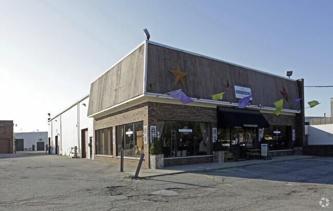
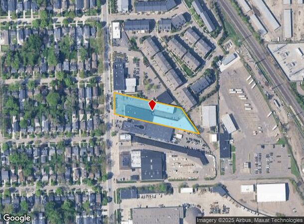
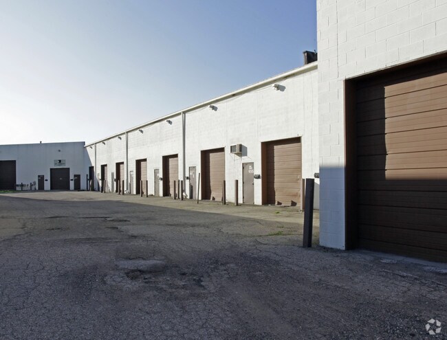
Property Record
639 S Eton St, Birmingham, MI 48009
NEARBY LISTINGS FOR SALE OR LEASE
Property Detail
639 S Eton St
20-31-203-009
T2N, R11E, SEC 31 ASSESSORS PLAT NO 28 LOT 6
Storebuilding
Oakland
X
Michigan
26125C0537F
6
2024
1.25 AC
2024
Troy Area West
153200
Detroit
22,981 SF
Detroit-Warren-Dearborn, MI
DEMOGRAPHICS near 639 S Eton St
1 Mile
3 Mile
5 Mile
2024 Total Population
13,482
101,195
244,939
2029 Population
13,389
100,469
242,686
Pop Growth 2024-2029
(0.69%)
(0.72%)
(0.92%)
Average Age
40
41
42
2024 Total Households
6,447
44,992
105,772
HH Growth 2024-2029
(0.70%)
(0.74%)
(0.90%)
Median Household Inc
$111,859
$101,696
$99,131
Avg Household Size
2.10
2.20
2.30
2024 Avg HH Vehicles
2.00
2.00
2.00
Median Home Value
$444,196
$356,342
$334,905
Median Year Built
1961
1962
1963
Nearby Places
Map Layers
Map Styles
 Street
 Aerial
- Restaurants
- Banks
- Shops
- Fitness
- Groceries
PUBLIC TRANSPORTATION
COMMUTER RAIL
Troy Amtrak Station (Wolverine - Amtrak)
DRIVE
WALK
Distance
Troy Amtrak Station (Wolverine - Amtrak)
3 min
17 min
0.9 mi
Royal Oak Amtrak (Wolverine - Amtrak)
DRIVE
WALK
Distance
Royal Oak Amtrak (Wolverine - Amtrak)
12 min
5.4 mi
AIRPORT
Windsor International
DRIVE
WALK
Distance
Windsor International
51 min
28.1 mi
Detroit Metro Wayne County
DRIVE
WALK
Distance
Detroit Metro Wayne County
51 min
31.4 mi
Freight Ports
Port of Toledo
DRIVE
WALK
Distance
Port of Toledo
100 min
73.4 mi
Nearby Properties
Address
Land Use
TOTAL SIZE
Lot Size
Zoning
Address
Land Use
TOTAL SIZE
Lot Size
Zoning
399,735 SF
19.71 AC
B2
Address
Land Use
TOTAL SIZE
Lot Size
Zoning
272,233 SF
90.90 AC
Address
Land Use
TOTAL SIZE
Lot Size
Zoning
224,766 SF
19.92 AC
B2
Address
Land Use
TOTAL SIZE
Lot Size
Zoning
300,925 SF
10.13 AC
Address
Land Use
TOTAL SIZE
Lot Size
Zoning
Address
Land Use
TOTAL SIZE
Lot Size
Zoning
512,475 SF
20.02 AC
Address
Land Use
TOTAL SIZE
Lot Size
Zoning
111,030 SF
0.97 AC
BI
Address
Land Use
TOTAL SIZE
Lot Size
Zoning
208,296 SF
8.16 AC
OSC
Address
Land Use
TOTAL SIZE
Lot Size
Zoning
149,395 SF
1.02 AC
BI
Address
Land Use
TOTAL SIZE
Lot Size
Zoning
272,233 SF
9.09 AC
OSC
Address
Land Use
TOTAL SIZE
Lot Size
Zoning
143,160 SF
0.84 AC
BI
Address
Land Use
TOTAL SIZE
Lot Size
Zoning
15.32 AC
GEN BUS
Address
Land Use
TOTAL SIZE
Lot Size
Zoning
99,661 SF
0.62 AC
Address
Land Use
TOTAL SIZE
Lot Size
Zoning
427,945 SF
18.26 AC
OSC
Address
Land Use
TOTAL SIZE
Lot Size
Zoning
236,140 SF
1.67 AC
BI
Address
Land Use
TOTAL SIZE
Lot Size
Zoning
250,868 SF
6 AC
OSC
Address
Land Use
TOTAL SIZE
Lot Size
Zoning
300,925 SF
10.13 AC
OSC
Address
Land Use
TOTAL SIZE
Lot Size
Zoning
300,924 SF
10.13 AC
Address
Land Use
TOTAL SIZE
Lot Size
Zoning
301,728 SF
2.83 AC
B2
Address
Land Use
TOTAL SIZE
Lot Size
Zoning
16,022 SF
4.07 AC
OSC
Address
Land Use
TOTAL SIZE
Lot Size
Zoning
83,244 SF
0.38 AC
Address
Land Use
TOTAL SIZE
Lot Size
Zoning
150,240 SF
10.70 AC
OSC
Address
Land Use
TOTAL SIZE
Lot Size
Zoning
206,913 SF
16.99 AC
O1
Address
Land Use
TOTAL SIZE
Lot Size
Zoning
72,457 SF
5.60 AC
OFFICE SVC
Address
Land Use
TOTAL SIZE
Lot Size
Zoning
4.21 AC
Address
Land Use
TOTAL SIZE
Lot Size
Zoning
279,360 SF
14.34 AC
RM1
Address
Land Use
TOTAL SIZE
Lot Size
Zoning
8,914 SF
5 AC
Address
Land Use
TOTAL SIZE
Lot Size
Zoning
76,260 SF
8.09 AC
Address
Land Use
TOTAL SIZE
Lot Size
Zoning
84,711 SF
5.05 AC
BI
Address
Land Use
TOTAL SIZE
Lot Size
Zoning
225,890 SF
10.10 AC
OM
The World's #1 Commercial Real Estate Marketplace
Connect with us
© 2025 CoStar Group
The information above has been obtained from sources believed reliable. While we do not doubt its accuracy we have not verified it and make no guarantee, warranty or representation about it. It is your responsibility to independently confirm its accuracy and completeness. Any projections, opinions, assumptions, or estimates used are for example only and do not represent the current or future performance of the property. The value of this transaction to you depends on tax and other factors which should be evaluated by your tax, financial, and legal advisors. You and your advisors should conduct a careful, independent investigation of the property to determine to your satisfaction the suitability of the property for your needs.