Property Record
639 Sinclair Ave, Staten Island, NY 10312
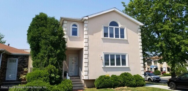

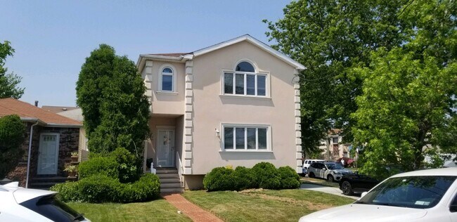
Property Detail
639 Sinclair Ave
06849-0055
Richmond
Commercialofficeresidentialmixeduse
New York
R3X
55
B and X Area of moderate flood hazard, usually the area between the limits of the 100-year and 500-year floods.
0.14 AC
2024
Staten Island
2025
Long Island (New York)
020804
New York-Jersey City-White Plains, NY-NJ
2,332 SF
NEARBY LISTINGS FOR SALE OR LEASE
DEMOGRAPHICS near 639 Sinclair Ave
1 mile
3 mile
5 mile
2025 Total Population
31,316
131,989
311,474
2030 Population
31,176
132,684
314,381
Pop Growth 2025-2030
(0.45%)
+ 0.53%
+ 0.93%
Average Age
42
42
41
2025 Total Households
11,187
46,874
108,830
HH Growth 2025-2030
(0.52%)
+ 0.48%
+ 1.01%
Median Household Inc
$110,945
$116,113
$101,108
Avg Household Size
2.80
2.80
2.80
2025 Avg HH Vehicles
2.00
2.00
2.00
Median Home Value
$752,977
$734,827
$677,563
Median Year Built
1983
1981
1975
Nearby Places
Map Layers
Map Styles
 Street
 Aerial
Layers
 Traffic
 Biking
Places
Listings with unknown addresses are not visible on the map
- Restaurants
- Banks
- Shops
- Fitness
- Groceries
PUBLIC TRANSPORTATION
TRANSIT/SUBWAY
Huguenot (Staten Island Railway - New York MTA Subway (The Subway))
Drive
Walk
Distance
Huguenot (Staten Island Railway - New York MTA Subway (The Subway))
3 min
14 min
0.7 mi
COMMUTER RAIL
Huguenot (Staten Island Railway - New York MTA Subway (The Subway))
Drive
Walk
Distance
Huguenot (Staten Island Railway - New York MTA Subway (The Subway))
3 min
14 min
0.7 mi
Prince's Bay (Staten Island Railway - New York MTA Subway (The Subway))
Drive
Walk
Distance
Prince's Bay (Staten Island Railway - New York MTA Subway (The Subway))
4 min
1.5 mi
AIRPORT
Newark Liberty International
Drive
Walk
Distance
Newark Liberty International
29 min
16.6 mi
LaGuardia
Drive
Walk
Distance
LaGuardia
52 min
31.4 mi
John F Kennedy International
Drive
Walk
Distance
John F Kennedy International
55 min
33.9 mi
Freight Ports
New York Container Terminal
Drive
Walk
Distance
New York Container Terminal
13 min
7.3 mi
SALE & LEASE HISTORY
LISTING DATE
SALE/LEASE

May 10, 2022
For Sale
Nearby Properties
Address
Land Use
TOTAL SIZE
Lot Size
Zoning
Address
Land Use
TOTAL SIZE
Lot Size
Zoning
196.03 AC
HIA
Address
Land Use
TOTAL SIZE
Lot Size
Zoning
794,430 SF
36.09 AC
R50
Address
Land Use
TOTAL SIZE
Lot Size
Zoning
237 AC
M1-1
Address
Land Use
TOTAL SIZE
Lot Size
Zoning
118 AC
M3-1
Address
Land Use
TOTAL SIZE
Lot Size
Zoning
404,985 SF
15.32 AC
R25
Address
Land Use
TOTAL SIZE
Lot Size
Zoning
196,382 SF
25.95 AC
Address
Land Use
TOTAL SIZE
Lot Size
Zoning
146 AC
PARK
Address
Land Use
TOTAL SIZE
Lot Size
Zoning
286,290 SF
21.24 AC
R50
Address
Land Use
TOTAL SIZE
Lot Size
Zoning
1.64 AC
R-25
Address
Land Use
TOTAL SIZE
Lot Size
Zoning
245,272 SF
18.54 AC
R50
Address
Land Use
TOTAL SIZE
Lot Size
Zoning
263,925 SF
11.98 AC
R50
Address
Land Use
TOTAL SIZE
Lot Size
Zoning
411,000 SF
18.54 AC
R3X
Address
Land Use
TOTAL SIZE
Lot Size
Zoning
55.47 AC
Address
Land Use
TOTAL SIZE
Lot Size
Zoning
21,120 SF
14.45 AC
R50
Address
Land Use
TOTAL SIZE
Lot Size
Zoning
5,214 SF
93 AC
M3-1
Address
Land Use
TOTAL SIZE
Lot Size
Zoning
214,392 SF
11.79 AC
R50
Address
Land Use
TOTAL SIZE
Lot Size
Zoning
Address
Land Use
TOTAL SIZE
Lot Size
Zoning
Address
Land Use
TOTAL SIZE
Lot Size
Zoning
11,140 SF
170.60 AC
PARK
Address
Land Use
TOTAL SIZE
Lot Size
Zoning
220,240 SF
5.77 AC
R3X
Address
Land Use
TOTAL SIZE
Lot Size
Zoning
38.58 AC
PARK
Address
Land Use
TOTAL SIZE
Lot Size
Zoning
505,000 SF
3.79 AC
R3A
Address
Land Use
TOTAL SIZE
Lot Size
Zoning
111,556 SF
9.86 AC
R50
Address
Land Use
TOTAL SIZE
Lot Size
Zoning
33.36 AC
PARK
Address
Land Use
TOTAL SIZE
Lot Size
Zoning
7.21 AC
R50
Address
Land Use
TOTAL SIZE
Lot Size
Zoning
2.32 AC
Address
Land Use
TOTAL SIZE
Lot Size
Zoning
2.32 AC
Address
Land Use
TOTAL SIZE
Lot Size
Zoning
2.32 AC
Address
Land Use
TOTAL SIZE
Lot Size
Zoning
108,000 SF
2.32 AC
Address
Land Use
TOTAL SIZE
Lot Size
Zoning
74,000 SF
523.69 AC
R3-2
The World's #1 Commercial Real Estate Marketplace
Connect with us
© 2026 CoStar Group
The information above has been obtained from sources believed reliable. While we do not doubt its accuracy we have not verified it and make no guarantee, warranty or representation about it. It is your responsibility to independently confirm its accuracy and completeness. Any projections, opinions, assumptions, or estimates used are for example only and do not represent the current or future performance of the property. The value of this transaction to you depends on tax and other factors which should be evaluated by your tax, financial, and legal advisors. You and your advisors should conduct a careful, independent investigation of the property to determine to your satisfaction the suitability of the property for your needs.