Property Record
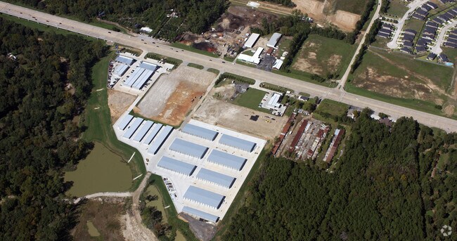
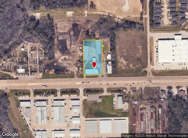
6390 Highway 105 W, Conroe, TX 77304
NEARBY LISTINGS FOR SALE OR LEASE
-
-
View all Conroe listings for sale on LoopNet.com
Property Detail
6390 Highway 105 W
0256-00-01502
Herndon P H
Commercialnec
A0256 HERNDON P H, TRACT 15-A,15-B (RIVERBRIDGE RESALE, RES A F#2007137780), ACRES 1.858
AE
Montgomery
48339C0360G
Texas
2024
1.86 AC
2025
Montgomery County
693701
Houston
9,285 SF
Houston-The Woodlands-Sugar Land, TX
DEMOGRAPHICS near 6390 Highway 105 W
1 Mile
3 Mile
5 Mile
2024 Total Population
2,908
23,286
79,414
2029 Population
3,657
28,896
98,092
Pop Growth 2024-2029
+ 25.76%
+ 24.09%
+ 23.52%
Average Age
40
39
40
2024 Total Households
1,144
9,135
30,218
HH Growth 2024-2029
+ 25.87%
+ 24.23%
+ 24.12%
Median Household Inc
$79,375
$81,631
$81,104
Avg Household Size
2.60
2.50
2.50
2024 Avg HH Vehicles
2.00
2.00
2.00
Median Home Value
$295,713
$316,646
$316,750
Median Year Built
2010
2010
2006
Nearby Places
Map Layers
Map Styles
 Street
 Aerial
- Restaurants
- Banks
- Shops
- Fitness
- Groceries
PUBLIC TRANSPORTATION
AIRPORT
George Bush Intcntl/Houston
DRIVE
WALK
Distance
George Bush Intcntl/Houston
45 min
35.8 mi
Freight Ports
Port of Houston
DRIVE
WALK
Distance
Port of Houston
68 min
51.5 mi
Nearby Properties
Address
Land Use
TOTAL SIZE
Lot Size
Zoning
Address
Land Use
TOTAL SIZE
Lot Size
Zoning
419,016 SF
26 AC
Address
Land Use
TOTAL SIZE
Lot Size
Zoning
294,336 SF
20.39 AC
Address
Land Use
TOTAL SIZE
Lot Size
Zoning
204,716 SF
15.51 AC
Address
Land Use
TOTAL SIZE
Lot Size
Zoning
229,345 SF
12.36 AC
1
Address
Land Use
TOTAL SIZE
Lot Size
Zoning
134,935 SF
10.50 AC
1
Address
Land Use
TOTAL SIZE
Lot Size
Zoning
250,716 SF
11.17 AC
1
Address
Land Use
TOTAL SIZE
Lot Size
Zoning
235,826 SF
15.29 AC
Address
Land Use
TOTAL SIZE
Lot Size
Zoning
134,621 SF
26.37 AC
Address
Land Use
TOTAL SIZE
Lot Size
Zoning
313,974 SF
25.03 AC
1
Address
Land Use
TOTAL SIZE
Lot Size
Zoning
157,996 SF
9 AC
Address
Land Use
TOTAL SIZE
Lot Size
Zoning
287,364 SF
23.45 AC
4
Address
Land Use
TOTAL SIZE
Lot Size
Zoning
203,934 SF
11.75 AC
Address
Land Use
TOTAL SIZE
Lot Size
Zoning
151,806 SF
9 AC
1
Address
Land Use
TOTAL SIZE
Lot Size
Zoning
114,349 SF
6.50 AC
1
Address
Land Use
TOTAL SIZE
Lot Size
Zoning
239,104 SF
65.54 AC
1
Address
Land Use
TOTAL SIZE
Lot Size
Zoning
114,547 SF
57.94 AC
1
Address
Land Use
TOTAL SIZE
Lot Size
Zoning
114,101 SF
43.80 AC
Address
Land Use
TOTAL SIZE
Lot Size
Zoning
402,840 SF
26.73 AC
Address
Land Use
TOTAL SIZE
Lot Size
Zoning
190,000 SF
7.54 AC
Address
Land Use
TOTAL SIZE
Lot Size
Zoning
67,936 SF
1.60 AC
Address
Land Use
TOTAL SIZE
Lot Size
Zoning
81,011 SF
21.53 AC
Address
Land Use
TOTAL SIZE
Lot Size
Zoning
103,800 SF
10.07 AC
Address
Land Use
TOTAL SIZE
Lot Size
Zoning
110,000 SF
10 AC
1
Address
Land Use
TOTAL SIZE
Lot Size
Zoning
107,432 SF
17.37 AC
Address
Land Use
TOTAL SIZE
Lot Size
Zoning
45,301 SF
13.18 AC
1
Address
Land Use
TOTAL SIZE
Lot Size
Zoning
68,576 SF
26.39 AC
Address
Land Use
TOTAL SIZE
Lot Size
Zoning
157,442 SF
29.18 AC
4
Address
Land Use
TOTAL SIZE
Lot Size
Zoning
68,967 SF
20.19 AC
1
Address
Land Use
TOTAL SIZE
Lot Size
Zoning
19,320 SF
12.20 AC
The World's #1 Commercial Real Estate Marketplace
Connect with us
© 2025 CoStar Group
The information above has been obtained from sources believed reliable. While we do not doubt its accuracy we have not verified it and make no guarantee, warranty or representation about it. It is your responsibility to independently confirm its accuracy and completeness. Any projections, opinions, assumptions, or estimates used are for example only and do not represent the current or future performance of the property. The value of this transaction to you depends on tax and other factors which should be evaluated by your tax, financial, and legal advisors. You and your advisors should conduct a careful, independent investigation of the property to determine to your satisfaction the suitability of the property for your needs.