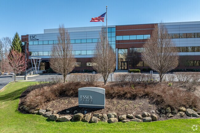
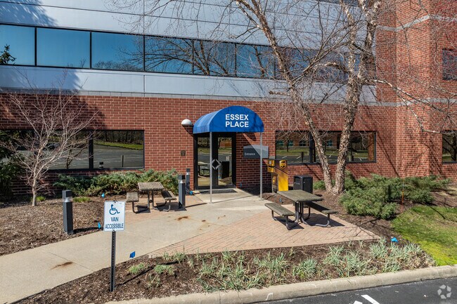
Property Record
6393 Oak Tree Blvd, Independence, OH 44131
NEARBY LISTINGS FOR SALE OR LEASE
Property Detail
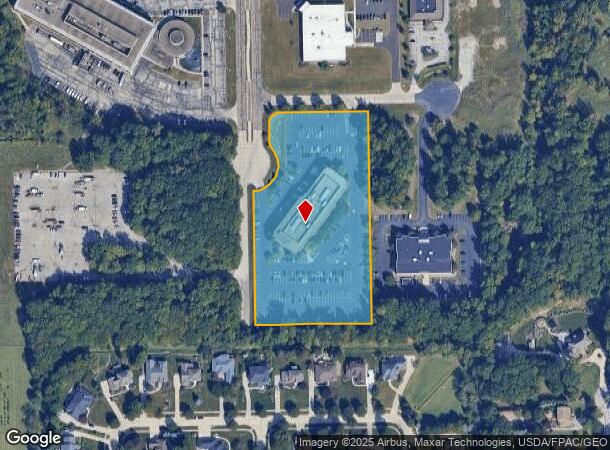
6393 Oak Tree Blvd
Cleveland-Elyria, OH
Acres
562-29-056
VOL 380 PG 52 PCL A-1A FF 196.85 D 393.87 4.5654 ACRES TR 2 OL 32 2016 SR
Officebuilding
Cuyahoga
X
Ohio
39035C0193E
a
2024
4.57 AC
2024
Rockside Corridor
156101
Cleveland
80,356 SF
DEMOGRAPHICS near 6393 Oak Tree Blvd
1 Mile
3 Mile
5 Mile
2024 Total Population
4,454
50,105
202,904
2029 Population
4,348
48,550
196,387
Pop Growth 2024-2029
(2.38%)
(3.10%)
(3.21%)
Average Age
45
44
42
2024 Total Households
1,812
21,318
86,022
HH Growth 2024-2029
(2.59%)
(3.33%)
(3.42%)
Median Household Inc
$101,079
$69,575
$56,195
Avg Household Size
2.40
2.30
2.30
2024 Avg HH Vehicles
2.00
2.00
2.00
Median Home Value
$238,569
$172,164
$143,954
Median Year Built
1965
1959
1955
Nearby Places
Map Layers
Map Styles
 Street
 Aerial
- Restaurants
- Banks
- Shops
- Fitness
- Groceries
PUBLIC TRANSPORTATION
COMMUTER RAIL
DRIVE
WALK
Distance
8 min
2.7 mi
DRIVE
WALK
Distance
10 min
4.2 mi
AIRPORT
Cleveland-Hopkins International
DRIVE
WALK
Distance
Cleveland-Hopkins International
25 min
12.1 mi
Akron-Canton Regional
DRIVE
WALK
Distance
Akron-Canton Regional
56 min
42.5 mi
SALE & LEASE HISTORY
LISTING DATE
SALE/LEASE

Jul 16, 2018
For Lease
Nearby Properties
Address
Land Use
TOTAL SIZE
Lot Size
Zoning
Address
Land Use
TOTAL SIZE
Lot Size
Zoning
162,711 SF
192.04 AC
IG
Address
Land Use
TOTAL SIZE
Lot Size
Zoning
202,152 SF
21.04 AC
U-1
Address
Land Use
TOTAL SIZE
Lot Size
Zoning
436,164 SF
20.01 AC
U-5
Address
Land Use
TOTAL SIZE
Lot Size
Zoning
384,714 SF
4.75 AC
U-5-HR
Address
Land Use
TOTAL SIZE
Lot Size
Zoning
307,703 SF
47.05 AC
U-5
Address
Land Use
TOTAL SIZE
Lot Size
Zoning
279,200 SF
37.19 AC
IG
Address
Land Use
TOTAL SIZE
Lot Size
Zoning
238,500 SF
20.31 AC
SC
Address
Land Use
TOTAL SIZE
Lot Size
Zoning
102,219 SF
14.01 AC
RB
Address
Land Use
TOTAL SIZE
Lot Size
Zoning
162,134 SF
12.24 AC
CG
Address
Land Use
TOTAL SIZE
Lot Size
Zoning
281,600 SF
18.73 AC
SF-A
Address
Land Use
TOTAL SIZE
Lot Size
Zoning
475,286 SF
5.81 AC
U-5-HR
Address
Land Use
TOTAL SIZE
Lot Size
Zoning
46,250 SF
16.36 AC
U-5
Address
Land Use
TOTAL SIZE
Lot Size
Zoning
239,000 SF
6.29 AC
U-6A
Address
Land Use
TOTAL SIZE
Lot Size
Zoning
60,989 SF
9.31 AC
U-4
Address
Land Use
TOTAL SIZE
Lot Size
Zoning
225,593 SF
4.79 AC
U-6A
Address
Land Use
TOTAL SIZE
Lot Size
Zoning
205,724 SF
6.54 AC
U-8
Address
Land Use
TOTAL SIZE
Lot Size
Zoning
168,322 SF
14.44 AC
Address
Land Use
TOTAL SIZE
Lot Size
Zoning
49,998 SF
19.72 AC
U-6
Address
Land Use
TOTAL SIZE
Lot Size
Zoning
260,000 SF
38.18 AC
U-5A
Address
Land Use
TOTAL SIZE
Lot Size
Zoning
209,068 SF
23.10 AC
IG
Address
Land Use
TOTAL SIZE
Lot Size
Zoning
277,049 SF
24.15 AC
2F
Address
Land Use
TOTAL SIZE
Lot Size
Zoning
19.48 AC
U5-A
Address
Land Use
TOTAL SIZE
Lot Size
Zoning
86,900 SF
18.01 AC
U-5
Address
Land Use
TOTAL SIZE
Lot Size
Zoning
162,134 SF
13.35 AC
CG
Address
Land Use
TOTAL SIZE
Lot Size
Zoning
124,224 SF
25.99 AC
U-1
Address
Land Use
TOTAL SIZE
Lot Size
Zoning
133,913 SF
18.36 AC
U-11B
Address
Land Use
TOTAL SIZE
Lot Size
Zoning
116,373 SF
13.28 AC
U-3
Address
Land Use
TOTAL SIZE
Lot Size
Zoning
54,055 SF
3.11 AC
U-4
Address
Land Use
TOTAL SIZE
Lot Size
Zoning
141,785 SF
9.13 AC
U-5
Address
Land Use
TOTAL SIZE
Lot Size
Zoning
37.77 AC
U-5A
The World's #1 Commercial Real Estate Marketplace
Connect with us
© 2025 CoStar Group
The information above has been obtained from sources believed reliable. While we do not doubt its accuracy we have not verified it and make no guarantee, warranty or representation about it. It is your responsibility to independently confirm its accuracy and completeness. Any projections, opinions, assumptions, or estimates used are for example only and do not represent the current or future performance of the property. The value of this transaction to you depends on tax and other factors which should be evaluated by your tax, financial, and legal advisors. You and your advisors should conduct a careful, independent investigation of the property to determine to your satisfaction the suitability of the property for your needs.