Property Record
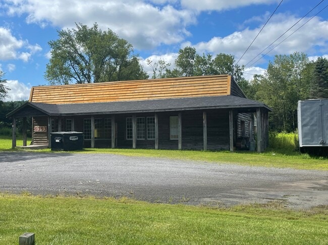
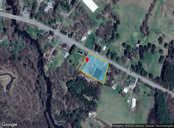
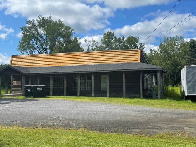
6393 State Highway 28, Fly Creek, NY 13337
NEARBY LISTINGS FOR SALE OR LEASE
-
-
View all Fly Creek listings for sale on LoopNet.com
Property Detail
6393 State Highway 28
365089-097-000-0002-037-001-0000
999 0 0
Distributionwarehouseregional
Otsego
X
New York
36077C0330E
37.001
2025
1.16 AC
2024
Otsego County
590202
Albany/Schenectady/Troy
2,900 SF
Oneonta, NY
DEMOGRAPHICS near 6393 State Highway 28
1 Mile
3 Mile
5 Mile
2024 Total Population
245
1,236
5,445
2029 Population
247
1,251
5,484
Pop Growth 2024-2029
+ 0.82%
+ 1.21%
+ 0.72%
Average Age
48
49
48
2024 Total Households
110
551
2,426
HH Growth 2024-2029
+ 1.82%
+ 1.27%
+ 0.82%
Median Household Inc
$100,595
$93,597
$77,057
Avg Household Size
2.20
2.10
2.10
2024 Avg HH Vehicles
2.00
2.00
2.00
Median Home Value
$394,999
$380,487
$304,341
Median Year Built
1956
1958
1949
Nearby Places
Map Layers
Map Styles
 Street
 Aerial
- Restaurants
- Banks
- Shops
- Fitness
- Groceries
SALE & LEASE HISTORY
LISTING DATE
SALE/LEASE

Aug 22, 2023
For Sale
Nearby Properties
Address
Land Use
TOTAL SIZE
Lot Size
Zoning
Address
Land Use
TOTAL SIZE
Lot Size
Zoning
2,700 SF
111.37 AC
01 - NOT Z
Address
Land Use
TOTAL SIZE
Lot Size
Zoning
8,528 SF
1.55 AC
01 - NOT Z
Address
Land Use
TOTAL SIZE
Lot Size
Zoning
864 SF
5.75 AC
01 - NOT Z
Address
Land Use
TOTAL SIZE
Lot Size
Zoning
7,752 SF
5.91 AC
Address
Land Use
TOTAL SIZE
Lot Size
Zoning
2,400 SF
5 AC
01 - NOT Z
Address
Land Use
TOTAL SIZE
Lot Size
Zoning
2,052 SF
1.39 AC
01 - NOT Z
Address
Land Use
TOTAL SIZE
Lot Size
Zoning
2,426 SF
118.88 AC
01 - NOT Z
Address
Land Use
TOTAL SIZE
Lot Size
Zoning
3,440 SF
12.78 AC
01 - NOT Z
Address
Land Use
TOTAL SIZE
Lot Size
Zoning
24.83 AC
01 - NOT Z
Address
Land Use
TOTAL SIZE
Lot Size
Zoning
0.40 AC
01 - NOT Z
Address
Land Use
TOTAL SIZE
Lot Size
Zoning
263.07 AC
01 - NOT Z
Address
Land Use
TOTAL SIZE
Lot Size
Zoning
4,500 SF
1.18 AC
01 - NOT Z
Address
Land Use
TOTAL SIZE
Lot Size
Zoning
3,406 SF
2.70 AC
01 - NOT Z
Address
Land Use
TOTAL SIZE
Lot Size
Zoning
5,500 SF
0.26 AC
01 - NOT Z
Address
Land Use
TOTAL SIZE
Lot Size
Zoning
2,422 SF
5.49 AC
01 - NOT Z
Address
Land Use
TOTAL SIZE
Lot Size
Zoning
2,980 SF
0.59 AC
01 - NOT Z
Address
Land Use
TOTAL SIZE
Lot Size
Zoning
6,200 SF
0.60 AC
01 - NOT Z
Address
Land Use
TOTAL SIZE
Lot Size
Zoning
3,344 SF
11.23 AC
01 - NOT Z
Address
Land Use
TOTAL SIZE
Lot Size
Zoning
4,160 SF
5.92 AC
01 - NOT Z
Address
Land Use
TOTAL SIZE
Lot Size
Zoning
792 SF
0.94 AC
01 - NOT Z
Address
Land Use
TOTAL SIZE
Lot Size
Zoning
2,287 SF
15.30 AC
01 - NOT Z
Address
Land Use
TOTAL SIZE
Lot Size
Zoning
358.17 AC
01 - NOT Z
Address
Land Use
TOTAL SIZE
Lot Size
Zoning
1,837 SF
8.50 AC
01 - NOT Z
Address
Land Use
TOTAL SIZE
Lot Size
Zoning
1,638 SF
7.95 AC
01 - NOT Z
Address
Land Use
TOTAL SIZE
Lot Size
Zoning
1,920 SF
3.99 AC
01 - NOT Z
Address
Land Use
TOTAL SIZE
Lot Size
Zoning
7,889 SF
2.06 AC
01 - NOT Z
Address
Land Use
TOTAL SIZE
Lot Size
Zoning
3,036 SF
0.54 AC
01 - NOT Z
Address
Land Use
TOTAL SIZE
Lot Size
Zoning
4,162 SF
0.19 AC
01 - NOT Z
Address
Land Use
TOTAL SIZE
Lot Size
Zoning
2,098 SF
68.60 AC
01 - NOT Z
Address
Land Use
TOTAL SIZE
Lot Size
Zoning
1,824 SF
9.51 AC
01 - NOT Z
The World's #1 Commercial Real Estate Marketplace
Connect with us
© 2026 CoStar Group
The information above has been obtained from sources believed reliable. While we do not doubt its accuracy we have not verified it and make no guarantee, warranty or representation about it. It is your responsibility to independently confirm its accuracy and completeness. Any projections, opinions, assumptions, or estimates used are for example only and do not represent the current or future performance of the property. The value of this transaction to you depends on tax and other factors which should be evaluated by your tax, financial, and legal advisors. You and your advisors should conduct a careful, independent investigation of the property to determine to your satisfaction the suitability of the property for your needs.