Property Record
6395 Chittenden Rd, Hudson, OH 44236
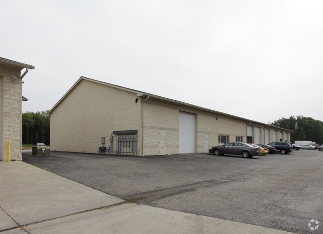


Property Detail
6395 Chittenden Rd
Akron, OH
PETTIT BROS FARMS ALLOTMENT LOTS 11 & 13 PRT LOT 12 ALL 11.0714 AC PB 19 PG 76-77
13-01012
Summit
Warehouse
Ohio
B and X Area of moderate flood hazard, usually the area between the limits of the 100-year and 500-year floods.
12
2022
9.02 AC
2024
Twinsburg/Aurora
532600
Cleveland
65,832 SF
NEARBY LISTINGS FOR SALE OR LEASE
DEMOGRAPHICS near 6395 Chittenden Rd
1 mile
3 mile
5 mile
2025 Total Population
953
15,287
51,862
2030 Population
970
15,353
51,904
Pop Growth 2025-2030
+ 1.78%
+ 0.43%
+ 0.08%
Average Age
45
43
42
2025 Total Households
369
5,682
20,018
HH Growth 2025-2030
+ 1.90%
+ 0.58%
+ 0.18%
Median Household Inc
$147,703
$158,820
$124,341
Avg Household Size
2.50
2.60
2.50
2025 Avg HH Vehicles
2.00
2.00
2.00
Median Home Value
$494,775
$453,846
$371,980
Median Year Built
1988
1991
1985
Nearby Places
Map Layers
Map Styles
 Street
 Aerial
Layers
 Traffic
 Biking
Places
Listings with unknown addresses are not visible on the map
- Restaurants
- Banks
- Shops
- Fitness
- Groceries
PUBLIC TRANSPORTATION
COMMUTER RAIL
Peninsula Depot (Lock 29) (National Park Scenic Railway - Cuyahoga Valley Scenic Railroad)
Drive
Walk
Distance
Peninsula Depot (Lock 29) (National Park Scenic Railway - Cuyahoga Valley Scenic Railroad)
8 min
4.1 mi
Boston Mill (National Park Scenic Railway - Cuyahoga Valley Scenic Railroad)
Drive
Walk
Distance
Boston Mill (National Park Scenic Railway - Cuyahoga Valley Scenic Railroad)
10 min
4.6 mi
AIRPORT
Akron-Canton Regional
Drive
Walk
Distance
Akron-Canton Regional
34 min
25.3 mi
Cleveland-Hopkins International
Drive
Walk
Distance
Cleveland-Hopkins International
41 min
29.4 mi
Freight Ports
Port of Toledo
Drive
Walk
Distance
Port of Toledo
144 min
123.8 mi
Nearby Properties
Address
Land Use
TOTAL SIZE
Lot Size
Zoning
Address
Land Use
TOTAL SIZE
Lot Size
Zoning
Address
Land Use
TOTAL SIZE
Lot Size
Zoning
665.83 AC
Address
Land Use
TOTAL SIZE
Lot Size
Zoning
439,460 SF
146.63 AC
Address
Land Use
TOTAL SIZE
Lot Size
Zoning
1,020,250 SF
63.69 AC
Address
Land Use
TOTAL SIZE
Lot Size
Zoning
Address
Land Use
TOTAL SIZE
Lot Size
Zoning
Address
Land Use
TOTAL SIZE
Lot Size
Zoning
114,568 SF
11.55 AC
Address
Land Use
TOTAL SIZE
Lot Size
Zoning
44,697 SF
17.83 AC
Address
Land Use
TOTAL SIZE
Lot Size
Zoning
110,681 SF
6.85 AC
Address
Land Use
TOTAL SIZE
Lot Size
Zoning
178.21 AC
Address
Land Use
TOTAL SIZE
Lot Size
Zoning
60,022 SF
3.63 AC
Address
Land Use
TOTAL SIZE
Lot Size
Zoning
258,840 SF
25.62 AC
Address
Land Use
TOTAL SIZE
Lot Size
Zoning
Address
Land Use
TOTAL SIZE
Lot Size
Zoning
107,836 SF
9.08 AC
Address
Land Use
TOTAL SIZE
Lot Size
Zoning
Address
Land Use
TOTAL SIZE
Lot Size
Zoning
Address
Land Use
TOTAL SIZE
Lot Size
Zoning
41,480 SF
7.09 AC
Address
Land Use
TOTAL SIZE
Lot Size
Zoning
111,766 SF
32.18 AC
Address
Land Use
TOTAL SIZE
Lot Size
Zoning
Address
Land Use
TOTAL SIZE
Lot Size
Zoning
31,442 SF
6.51 AC
Address
Land Use
TOTAL SIZE
Lot Size
Zoning
11,212 SF
0.93 AC
Address
Land Use
TOTAL SIZE
Lot Size
Zoning
64,212 SF
443.23 AC
Address
Land Use
TOTAL SIZE
Lot Size
Zoning
6.52 AC
Address
Land Use
TOTAL SIZE
Lot Size
Zoning
99,702 SF
10.86 AC
Address
Land Use
TOTAL SIZE
Lot Size
Zoning
41,774 SF
31.40 AC
Address
Land Use
TOTAL SIZE
Lot Size
Zoning
119,242 SF
10.26 AC
Address
Land Use
TOTAL SIZE
Lot Size
Zoning
157,022 SF
10.72 AC
Address
Land Use
TOTAL SIZE
Lot Size
Zoning
69,972 SF
15 AC
Address
Land Use
TOTAL SIZE
Lot Size
Zoning
Address
Land Use
TOTAL SIZE
Lot Size
Zoning
The World's #1 Commercial Real Estate Marketplace
Connect with us
© 2026 CoStar Group
The information above has been obtained from sources believed reliable. While we do not doubt its accuracy we have not verified it and make no guarantee, warranty or representation about it. It is your responsibility to independently confirm its accuracy and completeness. Any projections, opinions, assumptions, or estimates used are for example only and do not represent the current or future performance of the property. The value of this transaction to you depends on tax and other factors which should be evaluated by your tax, financial, and legal advisors. You and your advisors should conduct a careful, independent investigation of the property to determine to your satisfaction the suitability of the property for your needs.