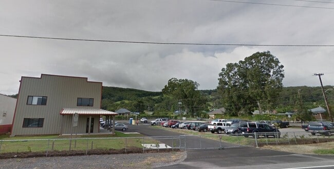
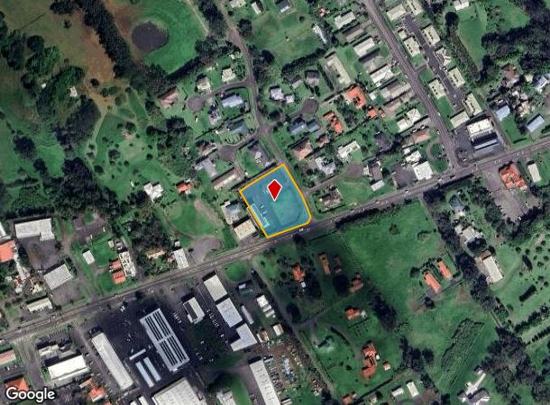
Property Record
64-998 Mamalahoa Hwy, Kamuela, HI 96743
NEARBY LISTINGS FOR SALE OR LEASE
-
-
View all Kamuela listings for sale on LoopNet.com
Property Detail
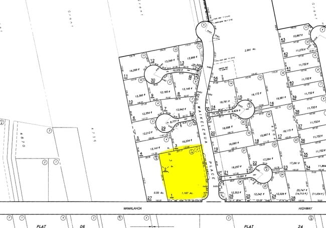
64-998 Mamalahoa Hwy
3-6-4-034-001-0000
Ranchlots Subdivision
Commercialnec
LOT 1-A 1.167 AC DES POR GR 4834 SUBJ/ESMT
AE
Hawaii
1551660193F
Hawaii
2024
1-a
2025
1.17 AC
021705
Other Market Areas
5,476 SF
Hilo, HI
DEMOGRAPHICS near 64-998 Mamalahoa Hwy
1 Mile
3 Mile
5 Mile
2024 Total Population
1,719
6,413
7,732
2029 Population
1,659
6,181
7,452
Pop Growth 2024-2029
(3.49%)
(3.62%)
(3.62%)
Average Age
40
40
40
2024 Total Households
572
2,148
2,590
HH Growth 2024-2029
(4.02%)
(4.14%)
(4.13%)
Median Household Inc
$108,531
$105,851
$103,927
Avg Household Size
2.80
2.80
2.80
2024 Avg HH Vehicles
2.00
2.00
2.00
Median Home Value
$552,083
$520,963
$508,355
Median Year Built
1987
1986
1986
Nearby Places
Map Layers
Map Styles
 Street
 Aerial
- Restaurants
- Banks
- Shops
- Fitness
- Groceries
PUBLIC TRANSPORTATION
AIRPORT
Ellison Onizuka Kona International at Keahole
DRIVE
WALK
Distance
Ellison Onizuka Kona International at Keahole
59 min
38.0 mi
Nearby Properties
Address
Land Use
TOTAL SIZE
Lot Size
Zoning
Address
Land Use
TOTAL SIZE
Lot Size
Zoning
82,568 SF
12.14 AC
RS-7.5
Address
Land Use
TOTAL SIZE
Lot Size
Zoning
140,892 SF
14.24 AC
CV-7.5
Address
Land Use
TOTAL SIZE
Lot Size
Zoning
19,144 SF
14.80 AC
A-40a
Address
Land Use
TOTAL SIZE
Lot Size
Zoning
39,019 SF
7.33 AC
CV-7.5
Address
Land Use
TOTAL SIZE
Lot Size
Zoning
73,071 SF
2.68 AC
CV-7.5
Address
Land Use
TOTAL SIZE
Lot Size
Zoning
19,860 SF
88.15 AC
A-40a
Address
Land Use
TOTAL SIZE
Lot Size
Zoning
8.90 AC
A-5a
Address
Land Use
TOTAL SIZE
Lot Size
Zoning
29,409 SF
3.23 AC
CV-7.5
Address
Land Use
TOTAL SIZE
Lot Size
Zoning
25,630 SF
191.71 AC
A-40a
Address
Land Use
TOTAL SIZE
Lot Size
Zoning
32,990 SF
1.32 AC
CV-7.5
Address
Land Use
TOTAL SIZE
Lot Size
Zoning
41,069 SF
4.02 AC
CN-7.5
Address
Land Use
TOTAL SIZE
Lot Size
Zoning
25,361 SF
2.07 AC
CV-7.5
Address
Land Use
TOTAL SIZE
Lot Size
Zoning
2,262 SF
4.02 AC
CV-7.5
Address
Land Use
TOTAL SIZE
Lot Size
Zoning
342 SF
5.99 AC
OPEN
Address
Land Use
TOTAL SIZE
Lot Size
Zoning
11,343 SF
2.15 AC
CV-7.5
Address
Land Use
TOTAL SIZE
Lot Size
Zoning
18,507 SF
2 AC
CV-7.5
Address
Land Use
TOTAL SIZE
Lot Size
Zoning
41,000 SF
19.45 AC
A-5a
Address
Land Use
TOTAL SIZE
Lot Size
Zoning
35,014 SF
46.96 AC
A-40a
Address
Land Use
TOTAL SIZE
Lot Size
Zoning
4.05 AC
3L
Address
Land Use
TOTAL SIZE
Lot Size
Zoning
16,204 SF
2.10 AC
CV-7.5
Address
Land Use
TOTAL SIZE
Lot Size
Zoning
16.90 AC
2L
Address
Land Use
TOTAL SIZE
Lot Size
Zoning
5,312 SF
3 AC
A-5a
Address
Land Use
TOTAL SIZE
Lot Size
Zoning
11,946 SF
0.94 AC
CV-7.5
Address
Land Use
TOTAL SIZE
Lot Size
Zoning
9,000 SF
1.15 AC
CV-7.5
Address
Land Use
TOTAL SIZE
Lot Size
Zoning
12,316 SF
1.61 AC
CV-7.5
Address
Land Use
TOTAL SIZE
Lot Size
Zoning
20,471 SF
1.57 AC
CN-7.5
Address
Land Use
TOTAL SIZE
Lot Size
Zoning
10,088 SF
8.09 AC
A-40a
Address
Land Use
TOTAL SIZE
Lot Size
Zoning
15,114 SF
1.36 AC
CV-7.5
Address
Land Use
TOTAL SIZE
Lot Size
Zoning
2,952 SF
6.24 AC
7C
Address
Land Use
TOTAL SIZE
Lot Size
Zoning
20,460 SF
1.01 AC
CN-7.5
The World's #1 Commercial Real Estate Marketplace
Connect with us
© 2025 CoStar Group
The information above has been obtained from sources believed reliable. While we do not doubt its accuracy we have not verified it and make no guarantee, warranty or representation about it. It is your responsibility to independently confirm its accuracy and completeness. Any projections, opinions, assumptions, or estimates used are for example only and do not represent the current or future performance of the property. The value of this transaction to you depends on tax and other factors which should be evaluated by your tax, financial, and legal advisors. You and your advisors should conduct a careful, independent investigation of the property to determine to your satisfaction the suitability of the property for your needs.