Property Record
351 Lloyd St, Cary, IL 60013
NEARBY LISTINGS FOR SALE OR LEASE
Property Detail
351 Lloyd St
Chicago-Naperville-Elgin, IL-IN-WI
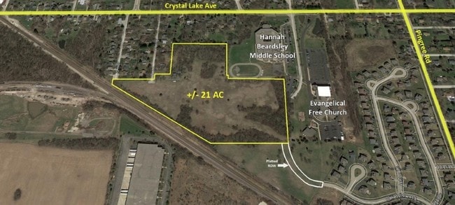
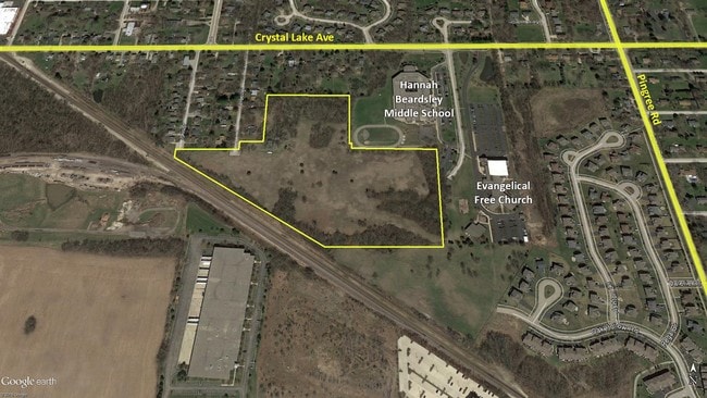
Crystal Heights Farm
19-04-203-002
WELY100FT LOT4
Taxexempt
McHenry
X
Illinois
17111C0335J
7
2022
6.06 AC
2024
Far Northwest
871305
Chicago
DEMOGRAPHICS near 351 Lloyd St
1 Mile
3 Mile
5 Mile
2024 Total Population
4,833
42,012
110,753
2029 Population
4,854
42,326
111,029
Pop Growth 2024-2029
+ 0.43%
+ 0.75%
+ 0.25%
Average Age
41
41
40
2024 Total Households
1,791
15,590
40,352
HH Growth 2024-2029
+ 0.45%
+ 0.76%
+ 0.28%
Median Household Inc
$97,997
$91,144
$96,201
Avg Household Size
2.60
2.60
2.70
2024 Avg HH Vehicles
2.00
2.00
2.00
Median Home Value
$300,175
$264,881
$266,101
Median Year Built
1990
1978
1987
Nearby Places
Map Layers
Map Styles
 Street
 Aerial
- Restaurants
- Banks
- Shops
- Fitness
- Groceries
PUBLIC TRANSPORTATION
COMMUTER RAIL
Cary Station (Union Pacific Northwest Line - Northeast Illinois Regional Commuter Railroad (Metra))
DRIVE
WALK
Distance
Cary Station (Union Pacific Northwest Line - Northeast Illinois Regional Commuter Railroad (Metra))
3 min
1.2 mi
Fox River Grove Station (Union Pacific Northwest Line - Northeast Illinois Regional Commuter Railroad (Metra))
DRIVE
WALK
Distance
Fox River Grove Station (Union Pacific Northwest Line - Northeast Illinois Regional Commuter Railroad (Metra))
6 min
2.7 mi
AIRPORT
Chicago O'Hare International
DRIVE
WALK
Distance
Chicago O'Hare International
47 min
31.1 mi
Freight Ports
Port Milwaukee
DRIVE
WALK
Distance
Port Milwaukee
97 min
71.5 mi
SALE & LEASE HISTORY
LISTING DATE
SALE/LEASE

Jun 13, 2017
For Sale
Nearby Properties
Address
Land Use
TOTAL SIZE
Lot Size
Zoning
Address
Land Use
TOTAL SIZE
Lot Size
Zoning
Address
Land Use
TOTAL SIZE
Lot Size
Zoning
28.48 AC
Address
Land Use
TOTAL SIZE
Lot Size
Zoning
449,650 SF
25 AC
Address
Land Use
TOTAL SIZE
Lot Size
Zoning
393,554 SF
83.76 AC
Address
Land Use
TOTAL SIZE
Lot Size
Zoning
20.81 AC
Address
Land Use
TOTAL SIZE
Lot Size
Zoning
217,182 SF
22.43 AC
Address
Land Use
TOTAL SIZE
Lot Size
Zoning
71,703 SF
0.50 AC
Address
Land Use
TOTAL SIZE
Lot Size
Zoning
47,164 SF
0.70 AC
Address
Land Use
TOTAL SIZE
Lot Size
Zoning
504,206 SF
11.06 AC
Address
Land Use
TOTAL SIZE
Lot Size
Zoning
55,547 SF
0.60 AC
Address
Land Use
TOTAL SIZE
Lot Size
Zoning
72,173 SF
5.23 AC
Address
Land Use
TOTAL SIZE
Lot Size
Zoning
161,610 SF
15.03 AC
Address
Land Use
TOTAL SIZE
Lot Size
Zoning
35,452 SF
105.76 AC
Address
Land Use
TOTAL SIZE
Lot Size
Zoning
124,301 SF
8.80 AC
Address
Land Use
TOTAL SIZE
Lot Size
Zoning
30.77 AC
Address
Land Use
TOTAL SIZE
Lot Size
Zoning
Address
Land Use
TOTAL SIZE
Lot Size
Zoning
4.74 AC
Address
Land Use
TOTAL SIZE
Lot Size
Zoning
75,205 SF
22.94 AC
Address
Land Use
TOTAL SIZE
Lot Size
Zoning
70,243 SF
11.36 AC
Address
Land Use
TOTAL SIZE
Lot Size
Zoning
56,537 SF
4.80 AC
Address
Land Use
TOTAL SIZE
Lot Size
Zoning
25,932 SF
6.43 AC
Address
Land Use
TOTAL SIZE
Lot Size
Zoning
152,670 SF
13 AC
Address
Land Use
TOTAL SIZE
Lot Size
Zoning
59,003 SF
5 AC
Address
Land Use
TOTAL SIZE
Lot Size
Zoning
64,872 SF
6.91 AC
Address
Land Use
TOTAL SIZE
Lot Size
Zoning
34,909 SF
8.79 AC
Address
Land Use
TOTAL SIZE
Lot Size
Zoning
112,744 SF
10.93 AC
Address
Land Use
TOTAL SIZE
Lot Size
Zoning
75,000 SF
4.64 AC
Address
Land Use
TOTAL SIZE
Lot Size
Zoning
26,015 SF
3.45 AC
The World's #1 Commercial Real Estate Marketplace
Connect with us
© 2025 CoStar Group
The information above has been obtained from sources believed reliable. While we do not doubt its accuracy we have not verified it and make no guarantee, warranty or representation about it. It is your responsibility to independently confirm its accuracy and completeness. Any projections, opinions, assumptions, or estimates used are for example only and do not represent the current or future performance of the property. The value of this transaction to you depends on tax and other factors which should be evaluated by your tax, financial, and legal advisors. You and your advisors should conduct a careful, independent investigation of the property to determine to your satisfaction the suitability of the property for your needs.