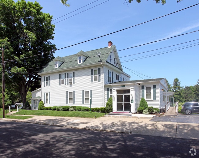
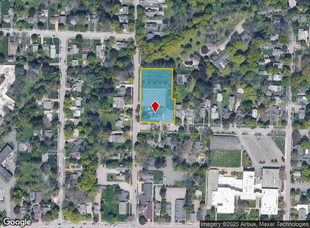
Property Record
64 Maple Rd, East Aurora, NY 14052


NEARBY LISTINGS FOR SALE OR LEASE
Property Detail
64 Maple Rd
142401-164-200-0004-036-000
Holland Land Companys Survey
Funeralhome
Erie
AE
New York
36029C0388H
36.000
2025
1.30 AC
2024
South
014000
Buffalo/Niagara Falls
7,790 SF
Buffalo-Cheektowaga-Niagara Falls, NY
DEMOGRAPHICS near 64 Maple Rd
1 Mile
3 Mile
5 Mile
2024 Total Population
6,777
14,328
27,932
2029 Population
6,774
14,326
27,903
Pop Growth 2024-2029
(0.04%)
(0.01%)
(0.10%)
Average Age
44
45
45
2024 Total Households
2,755
5,853
11,228
HH Growth 2024-2029
(0.18%)
(0.07%)
(0.18%)
Median Household Inc
$88,824
$94,369
$97,026
Avg Household Size
2.30
2.40
2.40
2024 Avg HH Vehicles
2.00
2.00
2.00
Median Home Value
$301,234
$303,279
$318,354
Median Year Built
1949
1957
1966
Nearby Places
- Restaurants
- Banks
- Shops
- Fitness
- Groceries
PUBLIC TRANSPORTATION
AIRPORT
Buffalo Niagara International
DRIVE
WALK
Distance
Buffalo Niagara International
29 min
16.4 mi
Niagara Falls International
DRIVE
WALK
Distance
Niagara Falls International
53 min
35.1 mi
Freight Ports
Albany, NY Port
DRIVE
WALK
Distance
Albany, NY Port
346 min
287.5 mi
Nearby Properties
Address
Land Use
TOTAL SIZE
Lot Size
Zoning
Address
Land Use
TOTAL SIZE
Lot Size
Zoning
155,392 SF
97.40 AC
Address
Land Use
TOTAL SIZE
Lot Size
Zoning
2,196 SF
23.80 AC
Address
Land Use
TOTAL SIZE
Lot Size
Zoning
121,465 SF
4.20 AC
Address
Land Use
TOTAL SIZE
Lot Size
Zoning
1,409 SF
2.70 AC
Address
Land Use
TOTAL SIZE
Lot Size
Zoning
167,315 SF
5.32 AC
Address
Land Use
TOTAL SIZE
Lot Size
Zoning
129,572 SF
13.10 AC
Address
Land Use
TOTAL SIZE
Lot Size
Zoning
62,903 SF
41.30 AC
Address
Land Use
TOTAL SIZE
Lot Size
Zoning
60,651 SF
2.01 AC
Address
Land Use
TOTAL SIZE
Lot Size
Zoning
178,744 SF
27.90 AC
Address
Land Use
TOTAL SIZE
Lot Size
Zoning
42,750 SF
1.10 AC
Address
Land Use
TOTAL SIZE
Lot Size
Zoning
7,512 SF
14.11 AC
Address
Land Use
TOTAL SIZE
Lot Size
Zoning
Address
Land Use
TOTAL SIZE
Lot Size
Zoning
124,495 SF
6.15 AC
Address
Land Use
TOTAL SIZE
Lot Size
Zoning
21,572 SF
2.76 AC
Address
Land Use
TOTAL SIZE
Lot Size
Zoning
13,364 SF
407.01 AC
N000
Address
Land Use
TOTAL SIZE
Lot Size
Zoning
15,990 SF
2.09 AC
Address
Land Use
TOTAL SIZE
Lot Size
Zoning
68,880 SF
11.66 AC
06 - INDUS
Address
Land Use
TOTAL SIZE
Lot Size
Zoning
34,575 SF
2.12 AC
Address
Land Use
TOTAL SIZE
Lot Size
Zoning
55,413 SF
3.19 AC
Address
Land Use
TOTAL SIZE
Lot Size
Zoning
142,587 SF
15.62 AC
Address
Land Use
TOTAL SIZE
Lot Size
Zoning
190,420 SF
117.90 AC
Address
Land Use
TOTAL SIZE
Lot Size
Zoning
13,874 SF
1.69 AC
Address
Land Use
TOTAL SIZE
Lot Size
Zoning
5,246 SF
2.42 AC
Address
Land Use
TOTAL SIZE
Lot Size
Zoning
Address
Land Use
TOTAL SIZE
Lot Size
Zoning
9.20 AC
Address
Land Use
TOTAL SIZE
Lot Size
Zoning
36,244 SF
1.80 AC
Address
Land Use
TOTAL SIZE
Lot Size
Zoning
13,708 SF
1.30 AC
Address
Land Use
TOTAL SIZE
Lot Size
Zoning
57,600 SF
3.24 AC
06 - INDUS
Address
Land Use
TOTAL SIZE
Lot Size
Zoning
864 SF
16.90 AC
Address
Land Use
TOTAL SIZE
Lot Size
Zoning
13,286 SF
1 AC
The World's #1 Commercial Real Estate Marketplace
Connect with us
© 2025 CoStar Group
The information above has been obtained from sources believed reliable. While we do not doubt its accuracy we have not verified it and make no guarantee, warranty or representation about it. It is your responsibility to independently confirm its accuracy and completeness. Any projections, opinions, assumptions, or estimates used are for example only and do not represent the current or future performance of the property. The value of this transaction to you depends on tax and other factors which should be evaluated by your tax, financial, and legal advisors. You and your advisors should conduct a careful, independent investigation of the property to determine to your satisfaction the suitability of the property for your needs.