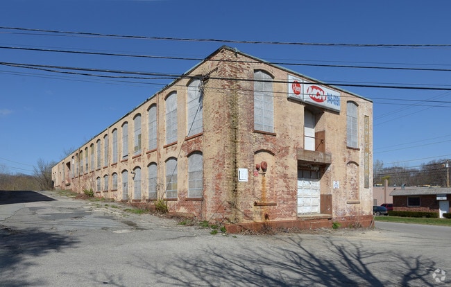
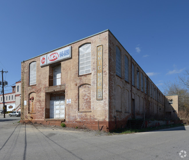
Property Record
64 Mill St, Johnston, RI 02919

Property Detail
64 Mill St
JOHN-000004-000000-000311
Providence
Apartment
Rhode Island
I
311
AE The base floodplain where base flood elevations are provided. AE Zones are now used on new format FIRMs instead of A1-A30 Zones.
0.89 AC
2025
Johnston
2025
Providence
012401
Providence-Warwick, RI-MA
15,484 SF
NEARBY LISTINGS FOR SALE OR LEASE
DEMOGRAPHICS near 64 Mill St
1 mile
3 mile
5 mile
2025 Total Population
11,534
107,743
298,119
2030 Population
12,023
110,897
306,605
Pop Growth 2025-2030
+ 4.24%
+ 2.93%
+ 2.85%
Average Age
44
40
39
2025 Total Households
5,036
40,892
114,161
HH Growth 2025-2030
+ 4.29%
+ 3.07%
+ 3.08%
Median Household Inc
$80,985
$76,226
$74,658
Avg Household Size
2.20
2.50
2.40
2025 Avg HH Vehicles
2.00
2.00
2.00
Median Home Value
$356,149
$363,161
$361,030
Median Year Built
1979
1960
1954
Nearby Places
Map Layers
Map Styles
 Street
 Aerial
Layers
 Traffic
 Biking
Places
Listings with unknown addresses are not visible on the map
- Restaurants
- Banks
- Shops
- Fitness
- Groceries
PUBLIC TRANSPORTATION
COMMUTER RAIL
Providence (Providence/Stoughton Line - Massachusetts Bay Transportation Authority Commuter Rail (Purple Line))
Drive
Walk
Distance
Providence (Providence/Stoughton Line - Massachusetts Bay Transportation Authority Commuter Rail (Purple Line))
10 min
5.4 mi
Tf Green Airport (Providence/Stoughton Line - MBTA)
Drive
Walk
Distance
Tf Green Airport (Providence/Stoughton Line - MBTA)
16 min
8.3 mi
AIRPORT
Rhode Island Tf Green International
Drive
Walk
Distance
Rhode Island Tf Green International
19 min
9.2 mi
Freight Ports
Port of Davisville, RI
Drive
Walk
Distance
Port of Davisville, RI
30 min
19.6 mi
SALE & LEASE HISTORY
LISTING DATE
SALE/LEASE

Jan 05, 2017
For Sale
Nearby Properties
Address
Land Use
TOTAL SIZE
Lot Size
Zoning
Address
Land Use
TOTAL SIZE
Lot Size
Zoning
9.06 AC
PS
Address
Land Use
TOTAL SIZE
Lot Size
Zoning
13.40 AC
C3
Address
Land Use
TOTAL SIZE
Lot Size
Zoning
91.15 AC
PUD
Address
Land Use
TOTAL SIZE
Lot Size
Zoning
4,954 SF
11.22 AC
C5
Address
Land Use
TOTAL SIZE
Lot Size
Zoning
136,906 SF
4.96 AC
PS
Address
Land Use
TOTAL SIZE
Lot Size
Zoning
333,161 SF
25.85 AC
B1
Address
Land Use
TOTAL SIZE
Lot Size
Zoning
32.30 AC
I
Address
Land Use
TOTAL SIZE
Lot Size
Zoning
27.47 AC
S1
Address
Land Use
TOTAL SIZE
Lot Size
Zoning
27.46 AC
C4
Address
Land Use
TOTAL SIZE
Lot Size
Zoning
30.14 AC
R40
Address
Land Use
TOTAL SIZE
Lot Size
Zoning
13,542 SF
95.26 AC
R10
Address
Land Use
TOTAL SIZE
Lot Size
Zoning
15.57 AC
M-MU-7
Address
Land Use
TOTAL SIZE
Lot Size
Zoning
15.35 AC
MPD
Address
Land Use
TOTAL SIZE
Lot Size
Zoning
5.54 AC
R-4
Address
Land Use
TOTAL SIZE
Lot Size
Zoning
12.81 AC
A8
Address
Land Use
TOTAL SIZE
Lot Size
Zoning
11.17 AC
A20
Address
Land Use
TOTAL SIZE
Lot Size
Zoning
10.76 AC
R-4
Address
Land Use
TOTAL SIZE
Lot Size
Zoning
184,286 SF
2.91 AC
C1
Address
Land Use
TOTAL SIZE
Lot Size
Zoning
64,882 SF
0.82 AC
R-2
Address
Land Use
TOTAL SIZE
Lot Size
Zoning
105,054 SF
18.73 AC
A6
Address
Land Use
TOTAL SIZE
Lot Size
Zoning
0.97 AC
A12
Address
Land Use
TOTAL SIZE
Lot Size
Zoning
6.60 AC
C3
Address
Land Use
TOTAL SIZE
Lot Size
Zoning
1 AC
R40
Address
Land Use
TOTAL SIZE
Lot Size
Zoning
138,360 SF
13.83 AC
C4
Address
Land Use
TOTAL SIZE
Lot Size
Zoning
137,536 SF
3.06 AC
S1
Address
Land Use
TOTAL SIZE
Lot Size
Zoning
7.06 AC
R20
Address
Land Use
TOTAL SIZE
Lot Size
Zoning
96.12 AC
I
Address
Land Use
TOTAL SIZE
Lot Size
Zoning
53,489 SF
3.58 AC
C4
Address
Land Use
TOTAL SIZE
Lot Size
Zoning
122,836 SF
15.10 AC
R40
Address
Land Use
TOTAL SIZE
Lot Size
Zoning
62,279 SF
5.09 AC
PS
The World's #1 Commercial Real Estate Marketplace
Connect with us
© 2026 CoStar Group
The information above has been obtained from sources believed reliable. While we do not doubt its accuracy we have not verified it and make no guarantee, warranty or representation about it. It is your responsibility to independently confirm its accuracy and completeness. Any projections, opinions, assumptions, or estimates used are for example only and do not represent the current or future performance of the property. The value of this transaction to you depends on tax and other factors which should be evaluated by your tax, financial, and legal advisors. You and your advisors should conduct a careful, independent investigation of the property to determine to your satisfaction the suitability of the property for your needs.