Property Record
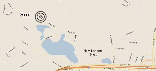
64 Pilgrim Rd, Quaker Hill, CT 06375

Save to a Folder
{{folder.Name}}
{{folder.ListingIds.length}} Properties
{{folder.ListingIds.length}} Property
Create a New Folder
Property Detail
64 Pilgrim Rd
WATE-000084-000000-006253
NEW LONDON
Taxexempt
Connecticut
R-40
6253
A Areas with a 1% annual chance of flooding and a 26% chance of flooding over the life of a 30-year mortgage.
158.50 AC
2025
New London
2025
Hartford
693700
Norwich-New London-Willimantic, CT
NEARBY LISTINGS FOR SALE OR LEASE
DEMOGRAPHICS near 64 Pilgrim Rd
1 mile
3 mile
5 mile
2025 Total Population
3,738
42,081
84,052
2030 Population
3,760
42,350
84,886
Pop Growth 2025-2030
+ 0.59%
+ 0.64%
+ 0.99%
Average Age
40
38
41
2025 Total Households
1,565
15,903
34,076
HH Growth 2025-2030
+ 0.51%
+ 0.79%
+ 1.11%
Median Household Inc
$77,893
$68,707
$80,487
Avg Household Size
2.20
2.30
2.20
2025 Avg HH Vehicles
2.00
2.00
2.00
Median Home Value
$315,641
$280,640
$310,479
Median Year Built
1966
1960
1967
Nearby Places
Map Layers
Map Styles
 Street
 Aerial
Layers
 Traffic
 Biking
Places
Listings with unknown addresses are not visible on the map
- Restaurants
- Banks
- Shops
- Fitness
- Groceries
PUBLIC TRANSPORTATION
COMMUTER RAIL
New London (Commuter Rail - Amtrak, Northeast Regional - Amtrak, Shore Line East Train - Amtrak)
Drive
Walk
Distance
New London (Commuter Rail - Amtrak, Northeast Regional - Amtrak, Shore Line East Train - Amtrak)
9 min
3.4 mi
Freight Ports
Port of Davisville, RI
Drive
Walk
Distance
Port of Davisville, RI
74 min
52.9 mi
Nearby Properties
Address
Land Use
TOTAL SIZE
Lot Size
Zoning
Address
Land Use
TOTAL SIZE
Lot Size
Zoning
45,582 SF
39.40 AC
WCI-1
Address
Land Use
TOTAL SIZE
Lot Size
Zoning
49.32 AC
R-3
Address
Land Use
TOTAL SIZE
Lot Size
Zoning
251.73 AC
RM40
Address
Land Use
TOTAL SIZE
Lot Size
Zoning
54.80 AC
INST
Address
Land Use
TOTAL SIZE
Lot Size
Zoning
21.84 AC
C-2
Address
Land Use
TOTAL SIZE
Lot Size
Zoning
41.89 AC
SDD
Address
Land Use
TOTAL SIZE
Lot Size
Zoning
60.63 AC
RU-20
Address
Land Use
TOTAL SIZE
Lot Size
Zoning
73,446 SF
69.87 AC
R-12
Address
Land Use
TOTAL SIZE
Lot Size
Zoning
47,148 SF
101.29 AC
IP-1
Address
Land Use
TOTAL SIZE
Lot Size
Zoning
55,766 SF
1.33 AC
R-4
Address
Land Use
TOTAL SIZE
Lot Size
Zoning
69,658 SF
16.31 AC
VR-10
Address
Land Use
TOTAL SIZE
Lot Size
Zoning
79,535 SF
3.03 AC
R-2
Address
Land Use
TOTAL SIZE
Lot Size
Zoning
135,113 SF
2.51 AC
LI-O
Address
Land Use
TOTAL SIZE
Lot Size
Zoning
9.41 AC
R-4
Address
Land Use
TOTAL SIZE
Lot Size
Zoning
129,890 SF
40.95 AC
R-20
Address
Land Use
TOTAL SIZE
Lot Size
Zoning
5.65 AC
R-2
Address
Land Use
TOTAL SIZE
Lot Size
Zoning
56.50 AC
C-R
Address
Land Use
TOTAL SIZE
Lot Size
Zoning
70,318 SF
5.20 AC
C-G
Address
Land Use
TOTAL SIZE
Lot Size
Zoning
52,065 SF
12.40 AC
CN
Address
Land Use
TOTAL SIZE
Lot Size
Zoning
12.55 AC
C-2
Address
Land Use
TOTAL SIZE
Lot Size
Zoning
79,469 SF
17.98 AC
IP-1
Address
Land Use
TOTAL SIZE
Lot Size
Zoning
18.76 AC
INST
Address
Land Use
TOTAL SIZE
Lot Size
Zoning
7,112 SF
R-12
Address
Land Use
TOTAL SIZE
Lot Size
Zoning
0.54 AC
CBD-1
Address
Land Use
TOTAL SIZE
Lot Size
Zoning
21.08 AC
C-G
Address
Land Use
TOTAL SIZE
Lot Size
Zoning
70.27 AC
R-40
Address
Land Use
TOTAL SIZE
Lot Size
Zoning
64,040 SF
4.57 AC
OS
Address
Land Use
TOTAL SIZE
Lot Size
Zoning
201,755 SF
58.13 AC
C-R
Address
Land Use
TOTAL SIZE
Lot Size
Zoning
68,045 SF
15.56 AC
IP-1
Address
Land Use
TOTAL SIZE
Lot Size
Zoning
99,569 SF
1.40 AC
R-4
The World's #1 Commercial Real Estate Marketplace
Connect with us
© 2026 CoStar Group
The information above has been obtained from sources believed reliable. While we do not doubt its accuracy we have not verified it and make no guarantee, warranty or representation about it. It is your responsibility to independently confirm its accuracy and completeness. Any projections, opinions, assumptions, or estimates used are for example only and do not represent the current or future performance of the property. The value of this transaction to you depends on tax and other factors which should be evaluated by your tax, financial, and legal advisors. You and your advisors should conduct a careful, independent investigation of the property to determine to your satisfaction the suitability of the property for your needs.