Property Record
64 Queen Rd, Intercourse, PA 17534

Property Detail
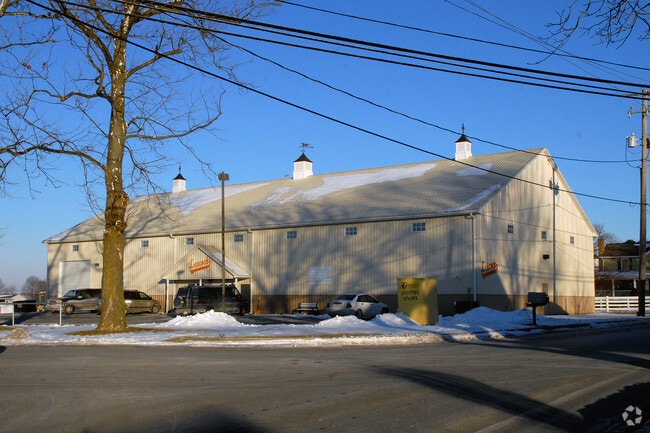
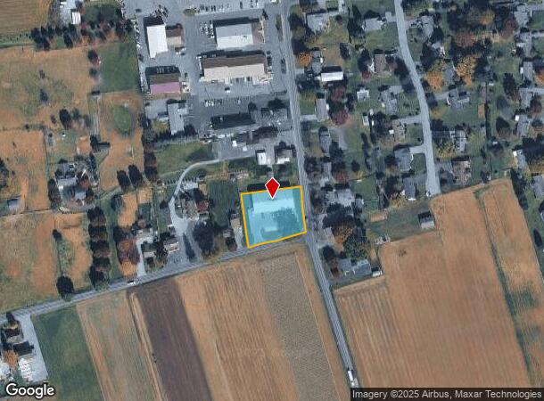
64 Queen Rd
Lancaster, PA
Springdale Farms Ph 02
350-70510-0-0000
64 QUEEN RD
Storebuilding
Lancaster
X
Pennsylvania
42071C0415F
9
2024
0.77 AC
2025
Lancaster County
014101
Philadelphia
12,248 SF
NEARBY LISTINGS FOR SALE OR LEASE
DEMOGRAPHICS near 64 Queen Rd
1 mile
3 mile
5 mile
2024 Total Population
1,803
7,937
26,307
2029 Population
1,779
7,849
26,294
Pop Growth 2024-2029
(1.33%)
(1.11%)
(0.05%)
Average Age
40
36
38
2024 Total Households
584
2,509
8,878
HH Growth 2024-2029
(1.37%)
(1.00%)
+ 0.14%
Median Household Inc
$75,223
$82,152
$75,718
Avg Household Size
3.00
3.10
2.90
2024 Avg HH Vehicles
1.00
1.00
2.00
Median Home Value
$354,166
$356,057
$294,350
Median Year Built
1976
1961
1973
Nearby Places
Map Layers
Map Styles
 Street
 Aerial
Transit
 Traffic
 Biking
Places
Listings with unknown addresses are not visible on the map
- Restaurants
- Banks
- Shops
- Fitness
- Groceries
PUBLIC TRANSPORTATION
AIRPORT
Harrisburg International
Drive
Walk
Distance
Harrisburg International
57 min
42.4 mi
Freight Ports
Port Newark Container Terminal
Drive
Walk
Distance
Port Newark Container Terminal
71 min
41.2 mi
SALE & LEASE HISTORY
LISTING DATE
SALE/LEASE

Mar 13, 2025
For Sale
Nearby Properties
Address
Land Use
TOTAL SIZE
Lot Size
Zoning
Address
Land Use
TOTAL SIZE
Lot Size
Zoning
237,119 SF
50.30 AC
A
Address
Land Use
TOTAL SIZE
Lot Size
Zoning
91,335 SF
11.80 AC
Address
Land Use
TOTAL SIZE
Lot Size
Zoning
103,083 SF
8.73 AC
A
Address
Land Use
TOTAL SIZE
Lot Size
Zoning
170,464 SF
8.60 AC
Address
Land Use
TOTAL SIZE
Lot Size
Zoning
87,756 SF
3.40 AC
Address
Land Use
TOTAL SIZE
Lot Size
Zoning
55,546 SF
9.70 AC
C-2
Address
Land Use
TOTAL SIZE
Lot Size
Zoning
108,854 SF
13 AC
C-I
Address
Land Use
TOTAL SIZE
Lot Size
Zoning
63,122 SF
4 AC
C-1
Address
Land Use
TOTAL SIZE
Lot Size
Zoning
44,862 SF
4.30 AC
Address
Land Use
TOTAL SIZE
Lot Size
Zoning
16,215 SF
9.50 AC
RES
Address
Land Use
TOTAL SIZE
Lot Size
Zoning
18,879 SF
7.60 AC
A
Address
Land Use
TOTAL SIZE
Lot Size
Zoning
63,786 SF
4.60 AC
C-I
Address
Land Use
TOTAL SIZE
Lot Size
Zoning
97,600 SF
12.70 AC
C-I
Address
Land Use
TOTAL SIZE
Lot Size
Zoning
42,073 SF
4 AC
Address
Land Use
TOTAL SIZE
Lot Size
Zoning
1,055 SF
10.20 AC
Address
Land Use
TOTAL SIZE
Lot Size
Zoning
54,456 SF
1.15 AC
C-1
Address
Land Use
TOTAL SIZE
Lot Size
Zoning
20,436 SF
2.15 AC
Address
Land Use
TOTAL SIZE
Lot Size
Zoning
27,317 SF
1.90 AC
C-2
Address
Land Use
TOTAL SIZE
Lot Size
Zoning
48,938 SF
163.61 AC
C-I
Address
Land Use
TOTAL SIZE
Lot Size
Zoning
40,647 SF
4.44 AC
Address
Land Use
TOTAL SIZE
Lot Size
Zoning
35,903 SF
4.90 AC
S-R
Address
Land Use
TOTAL SIZE
Lot Size
Zoning
54,908 SF
5.80 AC
C-I
Address
Land Use
TOTAL SIZE
Lot Size
Zoning
66,940 SF
2.10 AC
C-I
Address
Land Use
TOTAL SIZE
Lot Size
Zoning
5,894 SF
67.10 AC
A
Address
Land Use
TOTAL SIZE
Lot Size
Zoning
28,752 SF
5.34 AC
Address
Land Use
TOTAL SIZE
Lot Size
Zoning
20,140 SF
60.10 AC
AG
Address
Land Use
TOTAL SIZE
Lot Size
Zoning
51,580 SF
6.73 AC
Address
Land Use
TOTAL SIZE
Lot Size
Zoning
14,090 SF
7.20 AC
C-2
Address
Land Use
TOTAL SIZE
Lot Size
Zoning
16,512 SF
0.66 AC
Address
Land Use
TOTAL SIZE
Lot Size
Zoning
2.90 AC
C-1
The World's #1 Commercial Real Estate Marketplace
Connect with us
© 2026 CoStar Group
The information above has been obtained from sources believed reliable. While we do not doubt its accuracy we have not verified it and make no guarantee, warranty or representation about it. It is your responsibility to independently confirm its accuracy and completeness. Any projections, opinions, assumptions, or estimates used are for example only and do not represent the current or future performance of the property. The value of this transaction to you depends on tax and other factors which should be evaluated by your tax, financial, and legal advisors. You and your advisors should conduct a careful, independent investigation of the property to determine to your satisfaction the suitability of the property for your needs.