Property Record
640 E Old Linden Rd, Show Low, AZ 85901
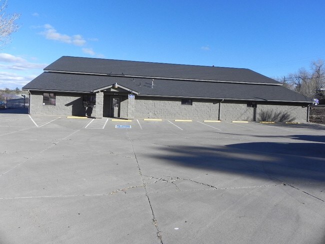

Property Detail
640 E Old Linden Rd
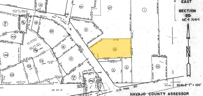
210-17-028
SECTION 20,T10N,R22E: BEG NW COR;TH S89DG54'3 E 2042.24'; TH S11DG18'W 544.9';TH S10DG33'6 W 332.94';TH S34'15'15 E 248'TPB TH S34DG15'15 E 103.96';TH N87DG55'E 268.03';TH N0DG22'08 W 147.25'; THW 221.08'; TH S55DEG44'45 W 126.24' TPOB
Autorepair
Navajo
MUNICIPAL
Arizona
B and X Area of moderate flood hazard, usually the area between the limits of the 100-year and 500-year floods.
1 AC
2024
Arizona Northeast & Holbrook Area
2026
Other Market Areas
965202
Show Low, AZ
8,000 SF
NEARBY LISTINGS FOR SALE OR LEASE
-
-
View all Show Low listings for sale on LoopNet.com
DEMOGRAPHICS near 640 E Old Linden Rd
1 mile
3 mile
5 mile
2025 Total Population
4,411
14,826
22,721
2030 Population
4,581
15,962
24,543
Pop Growth 2025-2030
+ 3.85%
+ 7.66%
+ 8.02%
Average Age
38
43
44
2025 Total Households
1,614
5,939
9,092
HH Growth 2025-2030
+ 3.10%
+ 7.24%
+ 7.74%
Median Household Inc
$65,040
$59,733
$58,923
Avg Household Size
2.60
2.40
2.40
2025 Avg HH Vehicles
2.00
2.00
2.00
Median Home Value
$280,314
$316,970
$331,133
Median Year Built
1989
1996
1997
Nearby Places
Map Layers
Map Styles
 Street
 Aerial
Layers
 Traffic
 Biking
Places
Listings with unknown addresses are not visible on the map
- Restaurants
- Banks
- Shops
- Fitness
- Groceries
Nearby Properties
Address
Land Use
TOTAL SIZE
Lot Size
Zoning
Address
Land Use
TOTAL SIZE
Lot Size
Zoning
147,745 SF
12.70 AC
MUNICIPAL
Address
Land Use
TOTAL SIZE
Lot Size
Zoning
81,647 SF
4.47 AC
MUNICIPAL
Address
Land Use
TOTAL SIZE
Lot Size
Zoning
74,338 SF
2.29 AC
Address
Land Use
TOTAL SIZE
Lot Size
Zoning
56,032 SF
4.60 AC
MUNICIPAL
Address
Land Use
TOTAL SIZE
Lot Size
Zoning
32,308 SF
10.46 AC
MUNICIPAL
Address
Land Use
TOTAL SIZE
Lot Size
Zoning
55,237 SF
6.03 AC
MUNICIPAL
Address
Land Use
TOTAL SIZE
Lot Size
Zoning
30,952 SF
5.72 AC
MUNICIPAL
Address
Land Use
TOTAL SIZE
Lot Size
Zoning
89,607 SF
5.78 AC
Address
Land Use
TOTAL SIZE
Lot Size
Zoning
29,707 SF
3 AC
MUNICIPAL
Address
Land Use
TOTAL SIZE
Lot Size
Zoning
32,762 SF
1.95 AC
MUNICIPAL
Address
Land Use
TOTAL SIZE
Lot Size
Zoning
30,942 SF
3.21 AC
MUNICIPAL
Address
Land Use
TOTAL SIZE
Lot Size
Zoning
46,700 SF
2.51 AC
MUNICIPAL
Address
Land Use
TOTAL SIZE
Lot Size
Zoning
33,421 SF
5.84 AC
MUNICIPAL
Address
Land Use
TOTAL SIZE
Lot Size
Zoning
19,280 SF
6.14 AC
MUNICIPAL
Address
Land Use
TOTAL SIZE
Lot Size
Zoning
76,060 SF
4.69 AC
MUNICIPAL
Address
Land Use
TOTAL SIZE
Lot Size
Zoning
8 AC
MUNICIPAL
Address
Land Use
TOTAL SIZE
Lot Size
Zoning
62,331 SF
4.20 AC
MUNICIPAL
Address
Land Use
TOTAL SIZE
Lot Size
Zoning
26,513 SF
9.76 AC
MUNICIPAL
Address
Land Use
TOTAL SIZE
Lot Size
Zoning
89,607 SF
3.97 AC
Address
Land Use
TOTAL SIZE
Lot Size
Zoning
21,291 SF
1.80 AC
MUNICIPAL
Address
Land Use
TOTAL SIZE
Lot Size
Zoning
16,349 SF
3.68 AC
MUNICIPAL
Address
Land Use
TOTAL SIZE
Lot Size
Zoning
24,000 SF
4.09 AC
MUNICIPAL
Address
Land Use
TOTAL SIZE
Lot Size
Zoning
17,948 SF
3.31 AC
MUNICIPAL
Address
Land Use
TOTAL SIZE
Lot Size
Zoning
31,443 SF
1.96 AC
MUNICIPAL
Address
Land Use
TOTAL SIZE
Lot Size
Zoning
24,876 SF
1.89 AC
MUNICIPAL
Address
Land Use
TOTAL SIZE
Lot Size
Zoning
22,705 SF
3.74 AC
MUNICIPAL
Address
Land Use
TOTAL SIZE
Lot Size
Zoning
10,880 SF
1.36 AC
MUNICIPAL
Address
Land Use
TOTAL SIZE
Lot Size
Zoning
19,369 SF
17.26 AC
MUNICIPAL
The World's #1 Commercial Real Estate Marketplace
Connect with us
© 2026 CoStar Group
The information above has been obtained from sources believed reliable. While we do not doubt its accuracy we have not verified it and make no guarantee, warranty or representation about it. It is your responsibility to independently confirm its accuracy and completeness. Any projections, opinions, assumptions, or estimates used are for example only and do not represent the current or future performance of the property. The value of this transaction to you depends on tax and other factors which should be evaluated by your tax, financial, and legal advisors. You and your advisors should conduct a careful, independent investigation of the property to determine to your satisfaction the suitability of the property for your needs.