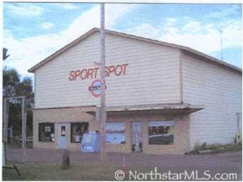
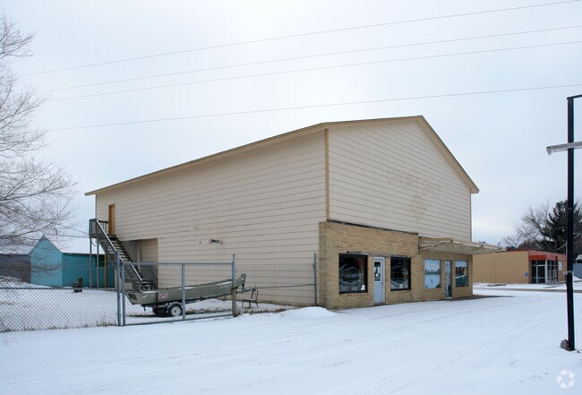
Property Record
640 Main St N, Cambridge, MN 55008

Property Detail
640 Main St N
Minneapolis-St. Paul-Bloomington, MN-WI
SUBDIVISIONNAME AUD SUB DIV 8 SUBDIVISIONCD 15041 PT OF LOTS 8, 9, 11, 13 OF AUD SUB 8 DESC AS: COMM AT THE SE CNR OF SAID LOT 9; THENCE W ALONG THE S LINE OF SAID LOTS 9 & 11 358.41' TO THE SLY ROW LINE OF MAIN ST N (FKA HWY 65); THENCE NELY ALONG S
15.041.0110
Isanti
Multipleuses
Minnesota
B and X Area of moderate flood hazard, usually the area between the limits of the 100-year and 500-year floods.
9
2026
0.40 AC
2025
Isanti County
130302
Minneapolis/St Paul
3,300 SF
NEARBY LISTINGS FOR SALE OR LEASE
DEMOGRAPHICS near 640 Main St N
1 mile
3 mile
5 mile
2025 Total Population
2,474
13,805
16,857
2030 Population
2,596
14,648
17,844
Pop Growth 2025-2030
+ 4.93%
+ 6.11%
+ 5.86%
Average Age
41
40
40
2025 Total Households
1,084
5,420
6,546
HH Growth 2025-2030
+ 4.80%
+ 6.14%
+ 5.91%
Median Household Inc
$53,148
$76,606
$79,208
Avg Household Size
2.20
2.50
2.50
2025 Avg HH Vehicles
2.00
2.00
2.00
Median Home Value
$252,430
$271,154
$279,988
Median Year Built
1977
1994
1993
Nearby Places
Map Layers
Map Styles
 Street
 Aerial
Layers
 Traffic
 Biking
Places
Listings with unknown addresses are not visible on the map
- Restaurants
- Banks
- Shops
- Fitness
- Groceries
Nearby Properties
Address
Land Use
TOTAL SIZE
Lot Size
Zoning
Address
Land Use
TOTAL SIZE
Lot Size
Zoning
21,734 SF
29.18 AC
Address
Land Use
TOTAL SIZE
Lot Size
Zoning
50,500 SF
9.60 AC
Address
Land Use
TOTAL SIZE
Lot Size
Zoning
198,232 SF
34.11 AC
Address
Land Use
TOTAL SIZE
Lot Size
Zoning
24,695 SF
6.95 AC
Address
Land Use
TOTAL SIZE
Lot Size
Zoning
203,800 SF
18.99 AC
Address
Land Use
TOTAL SIZE
Lot Size
Zoning
46,573 SF
6.78 AC
Address
Land Use
TOTAL SIZE
Lot Size
Zoning
184,416 SF
14.64 AC
Address
Land Use
TOTAL SIZE
Lot Size
Zoning
153,008 SF
17.25 AC
Address
Land Use
TOTAL SIZE
Lot Size
Zoning
41,400 SF
9.82 AC
Address
Land Use
TOTAL SIZE
Lot Size
Zoning
99,701 SF
40.42 AC
Address
Land Use
TOTAL SIZE
Lot Size
Zoning
127,850 SF
10.04 AC
Address
Land Use
TOTAL SIZE
Lot Size
Zoning
42,670 SF
60.36 AC
Address
Land Use
TOTAL SIZE
Lot Size
Zoning
40,169 SF
2.75 AC
Address
Land Use
TOTAL SIZE
Lot Size
Zoning
277,324 SF
4.67 AC
Address
Land Use
TOTAL SIZE
Lot Size
Zoning
45,757 SF
1.90 AC
Address
Land Use
TOTAL SIZE
Lot Size
Zoning
24,500 SF
14.27 AC
Address
Land Use
TOTAL SIZE
Lot Size
Zoning
14,779 SF
3.17 AC
Address
Land Use
TOTAL SIZE
Lot Size
Zoning
94,740 SF
14.91 AC
Address
Land Use
TOTAL SIZE
Lot Size
Zoning
17,280 SF
2.17 AC
Address
Land Use
TOTAL SIZE
Lot Size
Zoning
10,764 SF
2.98 AC
Address
Land Use
TOTAL SIZE
Lot Size
Zoning
2.13 AC
Address
Land Use
TOTAL SIZE
Lot Size
Zoning
7,184 SF
27.17 AC
Address
Land Use
TOTAL SIZE
Lot Size
Zoning
96,803 SF
10.95 AC
Address
Land Use
TOTAL SIZE
Lot Size
Zoning
50,481 SF
3.74 AC
Address
Land Use
TOTAL SIZE
Lot Size
Zoning
45,426 SF
15.60 AC
Address
Land Use
TOTAL SIZE
Lot Size
Zoning
17,050 SF
3.21 AC
Address
Land Use
TOTAL SIZE
Lot Size
Zoning
134,600 SF
7.72 AC
Address
Land Use
TOTAL SIZE
Lot Size
Zoning
26,684 SF
3.35 AC
Address
Land Use
TOTAL SIZE
Lot Size
Zoning
16,726 SF
1.98 AC
Address
Land Use
TOTAL SIZE
Lot Size
Zoning
90,438 SF
38.69 AC
The World's #1 Commercial Real Estate Marketplace
Connect with us
© 2026 CoStar Group
The information above has been obtained from sources believed reliable. While we do not doubt its accuracy we have not verified it and make no guarantee, warranty or representation about it. It is your responsibility to independently confirm its accuracy and completeness. Any projections, opinions, assumptions, or estimates used are for example only and do not represent the current or future performance of the property. The value of this transaction to you depends on tax and other factors which should be evaluated by your tax, financial, and legal advisors. You and your advisors should conduct a careful, independent investigation of the property to determine to your satisfaction the suitability of the property for your needs.