Property Record
6400 State Highway 195 Way, Florence, TX 76527
Save to a Folder
{{folder.Name}}
{{folder.ListingIds.length}} Properties
{{folder.ListingIds.length}} Property
Create a New Folder
Property Detail
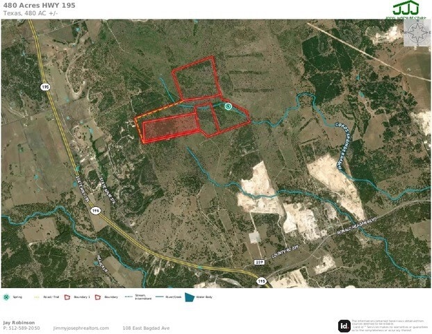
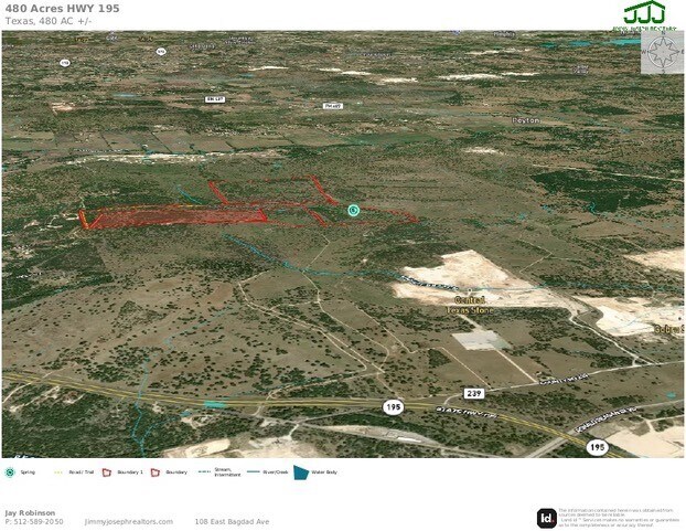
6400 State Highway 195 Way
Austin-Round Rock-San Marcos, TX
AW0244 AW0244 - GRAVIS, J.A.F. SUR., ACRES 190
R011316
WILLIAMSON
Agriculturalland
Texas
B and X Area of moderate flood hazard, usually the area between the limits of the 100-year and 500-year floods.
130 AC
2024
Georgetown
2025
Austin
020206
NEARBY LISTINGS FOR SALE OR LEASE
-
-
View all Florence listings for sale on LoopNet.com
DEMOGRAPHICS near 6400 State Highway 195 Way
1 mile
3 mile
5 mile
2025 Total Population
30
459
17,960
2030 Population
35
527
20,813
Pop Growth 2025-2030
+ 16.67%
+ 14.81%
+ 15.89%
Average Age
41
42
63
2025 Total Households
11
165
9,121
HH Growth 2025-2030
+ 18.18%
+ 15.15%
+ 16.09%
Median Household Inc
$39,999
$72,691
$96,612
Avg Household Size
2.70
2.80
2.00
2025 Avg HH Vehicles
3.00
2.00
2.00
Median Home Value
$483,333
$460,526
$497,622
Median Year Built
1994
1999
2010
Nearby Places
Map Layers
Map Styles
 Street
 Aerial
Layers
 Traffic
 Biking
Places
Listings with unknown addresses are not visible on the map
- Restaurants
- Banks
- Shops
- Fitness
- Groceries
PUBLIC TRANSPORTATION
AIRPORT
Killeen Municipal
Drive
Walk
Distance
Killeen Municipal
50 min
32.4 mi
Robert Gray AAF
Drive
Walk
Distance
Robert Gray AAF
54 min
33.2 mi
Freight Ports
Calhoun Port
Drive
Walk
Distance
Calhoun Port
231 min
195.9 mi
SALE & LEASE HISTORY
LISTING DATE
SALE/LEASE

Feb 14, 2024
For Sale
Nearby Properties
Address
Land Use
TOTAL SIZE
Lot Size
Zoning
Address
Land Use
TOTAL SIZE
Lot Size
Zoning
127,523 SF
50.60 AC
Address
Land Use
TOTAL SIZE
Lot Size
Zoning
127,523 SF
50.60 AC
Address
Land Use
TOTAL SIZE
Lot Size
Zoning
1,430 SF
584.30 AC
Address
Land Use
TOTAL SIZE
Lot Size
Zoning
155,448 SF
281.82 AC
Address
Land Use
TOTAL SIZE
Lot Size
Zoning
39,292 SF
200 AC
Address
Land Use
TOTAL SIZE
Lot Size
Zoning
21,600 SF
9.17 AC
Address
Land Use
TOTAL SIZE
Lot Size
Zoning
19,627 SF
23.79 AC
Address
Land Use
TOTAL SIZE
Lot Size
Zoning
159.30 AC
Address
Land Use
TOTAL SIZE
Lot Size
Zoning
9,840 SF
4.90 AC
Address
Land Use
TOTAL SIZE
Lot Size
Zoning
117.02 AC
Address
Land Use
TOTAL SIZE
Lot Size
Zoning
160 AC
Address
Land Use
TOTAL SIZE
Lot Size
Zoning
Address
Land Use
TOTAL SIZE
Lot Size
Zoning
8,255 SF
94.62 AC
Address
Land Use
TOTAL SIZE
Lot Size
Zoning
9,840 SF
3.54 AC
Address
Land Use
TOTAL SIZE
Lot Size
Zoning
155.90 AC
Address
Land Use
TOTAL SIZE
Lot Size
Zoning
10,580 SF
21.59 AC
Address
Land Use
TOTAL SIZE
Lot Size
Zoning
Address
Land Use
TOTAL SIZE
Lot Size
Zoning
11,394 SF
12 AC
Address
Land Use
TOTAL SIZE
Lot Size
Zoning
8,190 SF
23.95 AC
Address
Land Use
TOTAL SIZE
Lot Size
Zoning
1,080 SF
52.25 AC
Address
Land Use
TOTAL SIZE
Lot Size
Zoning
88.31 AC
Address
Land Use
TOTAL SIZE
Lot Size
Zoning
Address
Land Use
TOTAL SIZE
Lot Size
Zoning
5,177 SF
125.28 AC
Address
Land Use
TOTAL SIZE
Lot Size
Zoning
47.20 AC
Address
Land Use
TOTAL SIZE
Lot Size
Zoning
14.52 AC
Address
Land Use
TOTAL SIZE
Lot Size
Zoning
4,544 SF
3.73 AC
Address
Land Use
TOTAL SIZE
Lot Size
Zoning
4,384 SF
13.38 AC
Address
Land Use
TOTAL SIZE
Lot Size
Zoning
1,440 SF
27.96 AC
Address
Land Use
TOTAL SIZE
Lot Size
Zoning
43.92 AC
Address
Land Use
TOTAL SIZE
Lot Size
Zoning
264 SF
21.37 AC
The World's #1 Commercial Real Estate Marketplace
Connect with us
© 2026 CoStar Group
The information above has been obtained from sources believed reliable. While we do not doubt its accuracy we have not verified it and make no guarantee, warranty or representation about it. It is your responsibility to independently confirm its accuracy and completeness. Any projections, opinions, assumptions, or estimates used are for example only and do not represent the current or future performance of the property. The value of this transaction to you depends on tax and other factors which should be evaluated by your tax, financial, and legal advisors. You and your advisors should conduct a careful, independent investigation of the property to determine to your satisfaction the suitability of the property for your needs.