Property Record
6401 Montecito Blvd, Santa Rosa, CA 95409


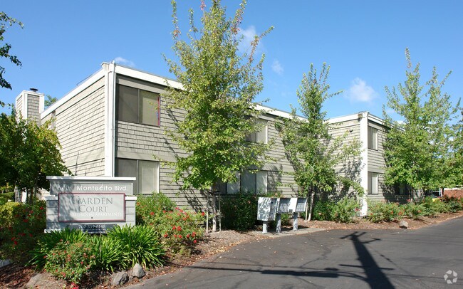

Property Detail
6401 Montecito Blvd
182-130-005
REMAP 032-240-008 08/11/98 LT 140 MONTECITO VLG #1
Apartment
Sonoma
CITYSR
California
B and X Area of moderate flood hazard, usually the area between the limits of the 100-year and 500-year floods.
140
2025
1.25 AC
2025
Outer Santa Rosa
152205
North Bay/Santa Rosa
22,992 SF
Santa Rosa-Petaluma, CA
NEARBY LISTINGS FOR SALE OR LEASE
DEMOGRAPHICS near 6401 Montecito Blvd
1 mile
3 mile
5 mile
2025 Total Population
11,424
64,853
160,621
2030 Population
11,453
65,406
161,974
Pop Growth 2025-2030
+ 0.25%
+ 0.85%
+ 0.84%
Average Age
44
46
42
2025 Total Households
4,604
26,959
61,357
HH Growth 2025-2030
+ 0.26%
+ 1.06%
+ 0.92%
Median Household Inc
$106,250
$112,594
$98,226
Avg Household Size
2.40
2.30
2.50
2025 Avg HH Vehicles
2.00
2.00
2.00
Median Home Value
$744,684
$824,972
$765,142
Median Year Built
1978
1975
1979
Nearby Places
Map Layers
Map Styles
 Street
 Aerial
Layers
 Traffic
 Biking
Places
Listings with unknown addresses are not visible on the map
- Restaurants
- Banks
- Shops
- Fitness
- Groceries
PUBLIC TRANSPORTATION
COMMUTER RAIL
Smart Santa Rosa North (Main Line - Sonoma Marin Area Rail Transit)
Drive
Walk
Distance
Smart Santa Rosa North (Main Line - Sonoma Marin Area Rail Transit)
10 min
4.6 mi
Smart Santa Rosa Downtown (Main Line - Sonoma Marin Area Rail Transit)
Drive
Walk
Distance
Smart Santa Rosa Downtown (Main Line - Sonoma Marin Area Rail Transit)
9 min
4.7 mi
AIRPORT
Charles M Schulz - Sonoma County
Drive
Walk
Distance
Charles M Schulz - Sonoma County
18 min
9.3 mi
Freight Ports
Port of Richmond
Drive
Walk
Distance
Port of Richmond
69 min
52.8 mi
Nearby Properties
Address
Land Use
TOTAL SIZE
Lot Size
Zoning
Address
Land Use
TOTAL SIZE
Lot Size
Zoning
191,452 SF
128.68 AC
CITYSR
Address
Land Use
TOTAL SIZE
Lot Size
Zoning
142,169 SF
7.42 AC
CITYSR
Address
Land Use
TOTAL SIZE
Lot Size
Zoning
22.45 AC
MCPD
Address
Land Use
TOTAL SIZE
Lot Size
Zoning
13,592 SF
30.22 AC
Address
Land Use
TOTAL SIZE
Lot Size
Zoning
Address
Land Use
TOTAL SIZE
Lot Size
Zoning
191,385 SF
13.77 AC
C2P
Address
Land Use
TOTAL SIZE
Lot Size
Zoning
131,210 SF
10.41 AC
Address
Land Use
TOTAL SIZE
Lot Size
Zoning
14,956 SF
9.77 AC
PC
Address
Land Use
TOTAL SIZE
Lot Size
Zoning
90,079 SF
3.09 AC
Address
Land Use
TOTAL SIZE
Lot Size
Zoning
184,758 SF
9.23 AC
Address
Land Use
TOTAL SIZE
Lot Size
Zoning
9,450 SF
0.76 AC
Address
Land Use
TOTAL SIZE
Lot Size
Zoning
107,765 SF
5.70 AC
CITYSR
Address
Land Use
TOTAL SIZE
Lot Size
Zoning
119,819 SF
7.37 AC
CITYSR
Address
Land Use
TOTAL SIZE
Lot Size
Zoning
19,996 SF
6.33 AC
Address
Land Use
TOTAL SIZE
Lot Size
Zoning
19,013 SF
9.46 AC
CITYSR
Address
Land Use
TOTAL SIZE
Lot Size
Zoning
58,551 SF
4.24 AC
Address
Land Use
TOTAL SIZE
Lot Size
Zoning
181,593 SF
0.80 AC
R3PD
Address
Land Use
TOTAL SIZE
Lot Size
Zoning
89,168 SF
5.50 AC
CITYSR
Address
Land Use
TOTAL SIZE
Lot Size
Zoning
53,024 SF
13.82 AC
CITYSR
Address
Land Use
TOTAL SIZE
Lot Size
Zoning
131,502 SF
8.60 AC
Address
Land Use
TOTAL SIZE
Lot Size
Zoning
28,384 SF
2.94 AC
CITYSR
Address
Land Use
TOTAL SIZE
Lot Size
Zoning
56,151 SF
4.21 AC
Address
Land Use
TOTAL SIZE
Lot Size
Zoning
128,092 SF
7.12 AC
Address
Land Use
TOTAL SIZE
Lot Size
Zoning
2,507 SF
4.19 AC
CITYSR
Address
Land Use
TOTAL SIZE
Lot Size
Zoning
38,567 SF
3.80 AC
PC
Address
Land Use
TOTAL SIZE
Lot Size
Zoning
26,320 SF
1.94 AC
CITYSR
Address
Land Use
TOTAL SIZE
Lot Size
Zoning
6,150 SF
6.57 AC
CITYSR
Address
Land Use
TOTAL SIZE
Lot Size
Zoning
52,150 SF
1.30 AC
R330
Address
Land Use
TOTAL SIZE
Lot Size
Zoning
2.04 AC
CITYSR
Address
Land Use
TOTAL SIZE
Lot Size
Zoning
67,872 SF
6.95 AC
The World's #1 Commercial Real Estate Marketplace
Connect with us
© 2026 CoStar Group
The information above has been obtained from sources believed reliable. While we do not doubt its accuracy we have not verified it and make no guarantee, warranty or representation about it. It is your responsibility to independently confirm its accuracy and completeness. Any projections, opinions, assumptions, or estimates used are for example only and do not represent the current or future performance of the property. The value of this transaction to you depends on tax and other factors which should be evaluated by your tax, financial, and legal advisors. You and your advisors should conduct a careful, independent investigation of the property to determine to your satisfaction the suitability of the property for your needs.