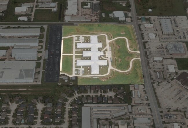
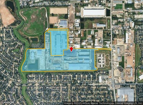
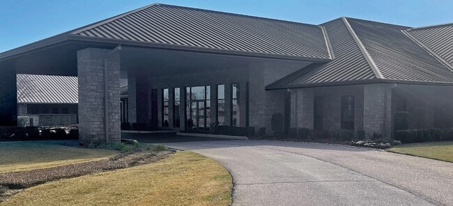
Property Record
6401 N Eldridge Pkwy, Houston, TX 77041
NEARBY LISTINGS FOR SALE OR LEASE
Property Detail
6401 N Eldridge Pkwy
Houston-The Woodlands-Sugar Land, TX
Dril Quip
1322250010001
PT RES A BLK 1 (POLLUTION CONTROL*1322250010002 & -0003) DRIL QUIP
Outdoorrecreationbeachmountaindesert
Harris
AE
Texas
48201C0630M
120.78 AC
2024
West Outer Loop
2025
Houston
540700
DEMOGRAPHICS near 6401 N Eldridge Pkwy
1 Mile
3 Mile
5 Mile
2024 Total Population
9,569
81,340
242,930
2029 Population
9,637
82,221
245,672
Pop Growth 2024-2029
+ 0.71%
+ 1.08%
+ 1.13%
Average Age
39
37
38
2024 Total Households
3,078
28,853
84,718
HH Growth 2024-2029
+ 0.65%
+ 1.11%
+ 1.09%
Median Household Inc
$88,962
$73,114
$74,859
Avg Household Size
3.00
2.80
2.80
2024 Avg HH Vehicles
2.00
2.00
2.00
Median Home Value
$267,188
$239,918
$229,026
Median Year Built
1994
1990
1991
Nearby Places
Map Layers
Map Styles
 Street
 Aerial
- Restaurants
- Banks
- Shops
- Fitness
- Groceries
PUBLIC TRANSPORTATION
AIRPORT
George Bush Intcntl/Houston
DRIVE
WALK
Distance
George Bush Intcntl/Houston
36 min
25.1 mi
William P Hobby
DRIVE
WALK
Distance
William P Hobby
54 min
33.7 mi
Freight Ports
Port of Houston
DRIVE
WALK
Distance
Port of Houston
45 min
29.3 mi
SALE & LEASE HISTORY
LISTING DATE
SALE/LEASE

May 31, 2022
For Sale
Nearby Properties
Address
Land Use
TOTAL SIZE
Lot Size
Zoning
Address
Land Use
TOTAL SIZE
Lot Size
Zoning
625,701 SF
52.20 AC
Address
Land Use
TOTAL SIZE
Lot Size
Zoning
664,361 SF
39.18 AC
Address
Land Use
TOTAL SIZE
Lot Size
Zoning
380,959 SF
21.43 AC
Address
Land Use
TOTAL SIZE
Lot Size
Zoning
386,642 SF
14.45 AC
Address
Land Use
TOTAL SIZE
Lot Size
Zoning
373,516 SF
18.63 AC
Address
Land Use
TOTAL SIZE
Lot Size
Zoning
358,713 SF
19.91 AC
Address
Land Use
TOTAL SIZE
Lot Size
Zoning
307,698 SF
13.12 AC
Address
Land Use
TOTAL SIZE
Lot Size
Zoning
387,245 SF
18.18 AC
Address
Land Use
TOTAL SIZE
Lot Size
Zoning
408,144 SF
26.13 AC
Address
Land Use
TOTAL SIZE
Lot Size
Zoning
392,185 SF
30.73 AC
Address
Land Use
TOTAL SIZE
Lot Size
Zoning
402,712 SF
25.64 AC
Address
Land Use
TOTAL SIZE
Lot Size
Zoning
491,051 SF
50 AC
Address
Land Use
TOTAL SIZE
Lot Size
Zoning
388,223 SF
14.99 AC
Address
Land Use
TOTAL SIZE
Lot Size
Zoning
363,896 SF
21.69 AC
Address
Land Use
TOTAL SIZE
Lot Size
Zoning
412,250 SF
45.79 AC
Address
Land Use
TOTAL SIZE
Lot Size
Zoning
112,440 SF
8.02 AC
Address
Land Use
TOTAL SIZE
Lot Size
Zoning
301,102 SF
12.58 AC
Address
Land Use
TOTAL SIZE
Lot Size
Zoning
327,674 SF
15.32 AC
Address
Land Use
TOTAL SIZE
Lot Size
Zoning
493,233 SF
25.82 AC
Address
Land Use
TOTAL SIZE
Lot Size
Zoning
232,717 SF
10.21 AC
Address
Land Use
TOTAL SIZE
Lot Size
Zoning
292,466 SF
12.18 AC
Address
Land Use
TOTAL SIZE
Lot Size
Zoning
312,939 SF
22.80 AC
Address
Land Use
TOTAL SIZE
Lot Size
Zoning
351,468 SF
16.05 AC
Address
Land Use
TOTAL SIZE
Lot Size
Zoning
324,733 SF
19.26 AC
Address
Land Use
TOTAL SIZE
Lot Size
Zoning
300,292 SF
15.65 AC
Address
Land Use
TOTAL SIZE
Lot Size
Zoning
215,773 SF
15.71 AC
Address
Land Use
TOTAL SIZE
Lot Size
Zoning
300,000 SF
20.07 AC
Address
Land Use
TOTAL SIZE
Lot Size
Zoning
250,178 SF
Address
Land Use
TOTAL SIZE
Lot Size
Zoning
407,472 SF
23.82 AC
The World's #1 Commercial Real Estate Marketplace
Connect with us
© 2026 CoStar Group
The information above has been obtained from sources believed reliable. While we do not doubt its accuracy we have not verified it and make no guarantee, warranty or representation about it. It is your responsibility to independently confirm its accuracy and completeness. Any projections, opinions, assumptions, or estimates used are for example only and do not represent the current or future performance of the property. The value of this transaction to you depends on tax and other factors which should be evaluated by your tax, financial, and legal advisors. You and your advisors should conduct a careful, independent investigation of the property to determine to your satisfaction the suitability of the property for your needs.