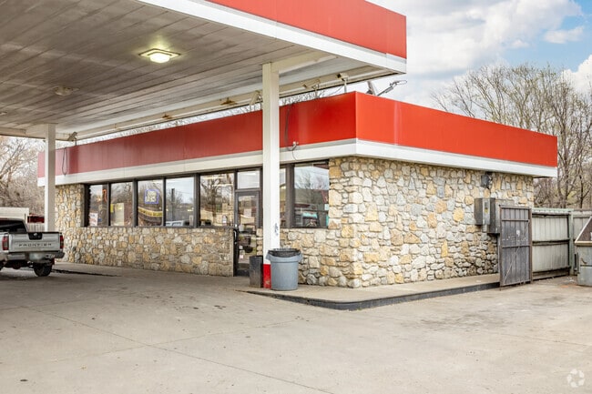
Property Record
6401 N Peoria Ave, Tulsa, OK 74126

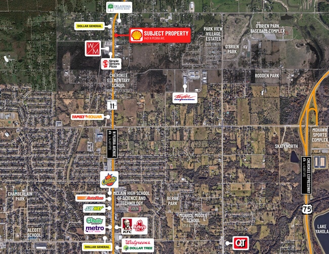
NEARBY LISTINGS FOR SALE OR LEASE
Property Detail
6401 N Peoria Ave
53325-03-06-02360
Golden Hill Second Addn
Storebuilding
PT BLK 16 BEG 165.5N SWC TH N165 E184 S165 W184 POB
X
Tulsa
40143C0226L
Oklahoma
2025
0.70 AC
2025
Northwest Tulsa
009104
Tulsa
1,104 SF
Tulsa, OK
DEMOGRAPHICS near 6401 N Peoria Ave
1 Mile
3 Mile
5 Mile
2024 Total Population
3,352
19,090
47,210
2029 Population
3,561
20,149
49,530
Pop Growth 2024-2029
+ 6.24%
+ 5.55%
+ 4.91%
Average Age
40
37
37
2024 Total Households
1,277
6,880
17,477
HH Growth 2024-2029
+ 6.34%
+ 5.61%
+ 4.96%
Median Household Inc
$39,689
$33,306
$34,587
Avg Household Size
2.50
2.60
2.60
2024 Avg HH Vehicles
2.00
2.00
2.00
Median Home Value
$71,299
$66,109
$82,872
Median Year Built
1965
1960
1961
Nearby Places
Map Layers
Map Styles
 Street
 Aerial
- Restaurants
- Banks
- Shops
- Fitness
- Groceries
PUBLIC TRANSPORTATION
AIRPORT
Tulsa International
DRIVE
WALK
Distance
Tulsa International
16 min
8.4 mi
Freight Ports
DRIVE
WALK
Distance
26 min
16.5 mi
SALE & LEASE HISTORY
LISTING DATE
SALE/LEASE

Mar 26, 2021
For Sale
Nearby Properties
Address
Land Use
TOTAL SIZE
Lot Size
Zoning
Address
Land Use
TOTAL SIZE
Lot Size
Zoning
92,407 SF
6.02 AC
CS
Address
Land Use
TOTAL SIZE
Lot Size
Zoning
144,570 SF
44.59 AC
RM2
Address
Land Use
TOTAL SIZE
Lot Size
Zoning
29,589 SF
12.37 AC
AG
Address
Land Use
TOTAL SIZE
Lot Size
Zoning
92,364 SF
8.58 AC
RM1
Address
Land Use
TOTAL SIZE
Lot Size
Zoning
33,340 SF
10.08 AC
AG
Address
Land Use
TOTAL SIZE
Lot Size
Zoning
43,225 SF
9.30 AC
RS3
Address
Land Use
TOTAL SIZE
Lot Size
Zoning
45,883 SF
10.29 AC
RS3
Address
Land Use
TOTAL SIZE
Lot Size
Zoning
55,867 SF
7.94 AC
RS
Address
Land Use
TOTAL SIZE
Lot Size
Zoning
5,670 SF
96.05 AC
AG
Address
Land Use
TOTAL SIZE
Lot Size
Zoning
51,810 SF
7.61 AC
CS
Address
Land Use
TOTAL SIZE
Lot Size
Zoning
27,403 SF
70.91 AC
AG
Address
Land Use
TOTAL SIZE
Lot Size
Zoning
31,154 SF
9.74 AC
RS3
Address
Land Use
TOTAL SIZE
Lot Size
Zoning
29,065 SF
111.30 AC
RS
Address
Land Use
TOTAL SIZE
Lot Size
Zoning
291,374 SF
26.06 AC
RM1
Address
Land Use
TOTAL SIZE
Lot Size
Zoning
39,867 SF
2.72 AC
CH
Address
Land Use
TOTAL SIZE
Lot Size
Zoning
29,572 SF
4.05 AC
RM1
Address
Land Use
TOTAL SIZE
Lot Size
Zoning
11,130 SF
1.78 AC
IL
Address
Land Use
TOTAL SIZE
Lot Size
Zoning
16,905 SF
4.91 AC
CH
Address
Land Use
TOTAL SIZE
Lot Size
Zoning
1 SF
228.69 AC
AG
Address
Land Use
TOTAL SIZE
Lot Size
Zoning
1,200 SF
38.79 AC
AG
Address
Land Use
TOTAL SIZE
Lot Size
Zoning
5,704 SF
0.55 AC
CH
Address
Land Use
TOTAL SIZE
Lot Size
Zoning
7,129 SF
4.15 AC
IM
Address
Land Use
TOTAL SIZE
Lot Size
Zoning
1,375 SF
15.01 AC
RS3
Address
Land Use
TOTAL SIZE
Lot Size
Zoning
8,159 SF
2.05 AC
AG
Address
Land Use
TOTAL SIZE
Lot Size
Zoning
11,843 SF
8.90 AC
CS
Address
Land Use
TOTAL SIZE
Lot Size
Zoning
9.49 AC
Address
Land Use
TOTAL SIZE
Lot Size
Zoning
11,598 SF
5 AC
RS
Address
Land Use
TOTAL SIZE
Lot Size
Zoning
16,619 SF
2.31 AC
AG
Address
Land Use
TOTAL SIZE
Lot Size
Zoning
13,055 SF
9.84 AC
RS3
Address
Land Use
TOTAL SIZE
Lot Size
Zoning
9,646 SF
3.09 AC
RS3
The World's #1 Commercial Real Estate Marketplace
Connect with us
© 2026 CoStar Group
The information above has been obtained from sources believed reliable. While we do not doubt its accuracy we have not verified it and make no guarantee, warranty or representation about it. It is your responsibility to independently confirm its accuracy and completeness. Any projections, opinions, assumptions, or estimates used are for example only and do not represent the current or future performance of the property. The value of this transaction to you depends on tax and other factors which should be evaluated by your tax, financial, and legal advisors. You and your advisors should conduct a careful, independent investigation of the property to determine to your satisfaction the suitability of the property for your needs.