Property Record
6404 Monclova Rd, Maumee, OH 43537
NEARBY LISTINGS FOR SALE OR LEASE
Property Detail
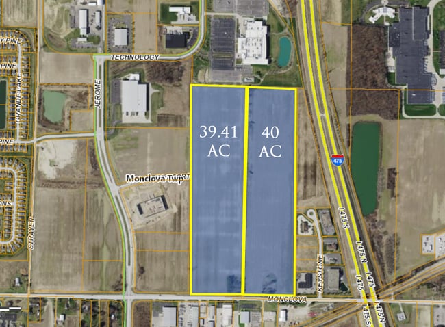
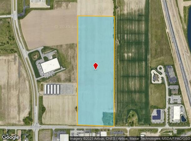
6404 Monclova Rd
38-00574
1 3 NW 1/4 E 1/4 EXC N 630.85 FT W 668.23 FT & EXC PT IN RD
Industrialacreage
Lucas
X
Ohio
39173C0005D
29.35 AC
0
South/Southwest
2025
Toledo
009002
Toledo, OH
DEMOGRAPHICS near 6404 Monclova Rd
1 mile
3 mile
5 mile
2024 Total Population
2,489
37,052
105,641
2029 Population
2,420
36,610
104,688
Pop Growth 2024-2029
(2.77%)
(1.19%)
(0.90%)
Average Age
52
42
41
2024 Total Households
1,159
15,350
44,195
HH Growth 2024-2029
(2.76%)
(1.39%)
(1.05%)
Median Household Inc
$100,625
$88,318
$75,313
Avg Household Size
2.10
2.40
2.30
2024 Avg HH Vehicles
2.00
2.00
2.00
Median Home Value
$276,385
$256,620
$218,643
Median Year Built
2006
1985
1979
Nearby Places
Map Layers
Map Styles
 Street
 Aerial
Transit
 Traffic
 Biking
Places
Listings with unknown addresses are not visible on the map
- Restaurants
- Banks
- Shops
- Fitness
- Groceries
PUBLIC TRANSPORTATION
AIRPORT
Eugene F Kranz Toledo Express
Drive
Walk
Distance
Eugene F Kranz Toledo Express
21 min
9.2 mi
Freight Ports
Port of Toledo
Drive
Walk
Distance
Port of Toledo
30 min
17.1 mi
SALE & LEASE HISTORY
LISTING DATE
SALE/LEASE

Jan 18, 2023
For Sale
Nearby Properties
Address
Land Use
TOTAL SIZE
Lot Size
Zoning
Address
Land Use
TOTAL SIZE
Lot Size
Zoning
541,518 SF
21.30 AC
16-R1
Address
Land Use
TOTAL SIZE
Lot Size
Zoning
275,990 SF
49.65 AC
16-CM
Address
Land Use
TOTAL SIZE
Lot Size
Zoning
67,264 SF
6.95 AC
16-CM
Address
Land Use
TOTAL SIZE
Lot Size
Zoning
35.94 AC
17-C3
Address
Land Use
TOTAL SIZE
Lot Size
Zoning
3.56 AC
Address
Land Use
TOTAL SIZE
Lot Size
Zoning
231,756 SF
31.37 AC
16-M1
Address
Land Use
TOTAL SIZE
Lot Size
Zoning
606,883 SF
119.87 AC
16-M2
Address
Land Use
TOTAL SIZE
Lot Size
Zoning
352,382 SF
62.93 AC
16-M1
Address
Land Use
TOTAL SIZE
Lot Size
Zoning
337,990 SF
17.75 AC
16-M1
Address
Land Use
TOTAL SIZE
Lot Size
Zoning
8.57 AC
16-M1
Address
Land Use
TOTAL SIZE
Lot Size
Zoning
608,280 SF
48.86 AC
16-M2
Address
Land Use
TOTAL SIZE
Lot Size
Zoning
212,672 SF
15.98 AC
17-R1
Address
Land Use
TOTAL SIZE
Lot Size
Zoning
350,408 SF
20.83 AC
17-M2
Address
Land Use
TOTAL SIZE
Lot Size
Zoning
214,986 SF
17.55 AC
19-R1
Address
Land Use
TOTAL SIZE
Lot Size
Zoning
119.87 AC
16-M2
Address
Land Use
TOTAL SIZE
Lot Size
Zoning
78,166 SF
2.08 AC
16-CM
Address
Land Use
TOTAL SIZE
Lot Size
Zoning
104,314 SF
15.43 AC
16-M2
Address
Land Use
TOTAL SIZE
Lot Size
Zoning
32.75 AC
16-M2
Address
Land Use
TOTAL SIZE
Lot Size
Zoning
160,811 SF
10.83 AC
10-MX
Address
Land Use
TOTAL SIZE
Lot Size
Zoning
86,450 SF
6.33 AC
17-R3
Address
Land Use
TOTAL SIZE
Lot Size
Zoning
262,764 SF
30.39 AC
17-M1
Address
Land Use
TOTAL SIZE
Lot Size
Zoning
55,124 SF
0.12 AC
16-C3
Address
Land Use
TOTAL SIZE
Lot Size
Zoning
3.12 AC
16-CM
Address
Land Use
TOTAL SIZE
Lot Size
Zoning
69,707 SF
9.36 AC
17-RA
Address
Land Use
TOTAL SIZE
Lot Size
Zoning
93,531 SF
13.31 AC
16-C2
Address
Land Use
TOTAL SIZE
Lot Size
Zoning
67,773 SF
5.85 AC
19-PO
Address
Land Use
TOTAL SIZE
Lot Size
Zoning
48,640 SF
10.98 AC
17-R1
Address
Land Use
TOTAL SIZE
Lot Size
Zoning
74,276 SF
13.08 AC
Address
Land Use
TOTAL SIZE
Lot Size
Zoning
128,249 SF
55.62 AC
17-MX
Address
Land Use
TOTAL SIZE
Lot Size
Zoning
133,079 SF
15.45 AC
10-CR
The World's #1 Commercial Real Estate Marketplace
Connect with us
© 2026 CoStar Group
The information above has been obtained from sources believed reliable. While we do not doubt its accuracy we have not verified it and make no guarantee, warranty or representation about it. It is your responsibility to independently confirm its accuracy and completeness. Any projections, opinions, assumptions, or estimates used are for example only and do not represent the current or future performance of the property. The value of this transaction to you depends on tax and other factors which should be evaluated by your tax, financial, and legal advisors. You and your advisors should conduct a careful, independent investigation of the property to determine to your satisfaction the suitability of the property for your needs.