Property Record
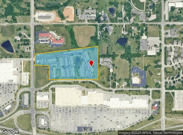
6405 Maurer Rd, Shawnee, KS 66217
NEARBY LISTINGS FOR SALE OR LEASE
-
-
View all Shawnee listings for sale on LoopNet.com
Property Detail
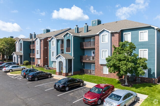
6405 Maurer Rd
Kansas City, MO-KS
Shawnee Station Apartments
QP66720000-0001
SHAWNEE STATION APARTMENTS LT 1 SHC 580I 1 1
Apartment
Johnson
X
Kansas
20209C0145E
1
2024
15.53 AC
2024
Outlying Johnson County KS
052308
Kansas City
51,320 SF
DEMOGRAPHICS near 6405 Maurer Rd
1 Mile
3 Mile
5 Mile
2024 Total Population
4,142
46,811
142,456
2029 Population
4,275
48,386
147,307
Pop Growth 2024-2029
+ 3.21%
+ 3.36%
+ 3.41%
Average Age
40
41
39
2024 Total Households
1,979
19,001
58,192
HH Growth 2024-2029
+ 3.39%
+ 3.42%
+ 3.58%
Median Household Inc
$67,010
$91,595
$82,747
Avg Household Size
2.00
2.40
2.40
2024 Avg HH Vehicles
2.00
2.00
2.00
Median Home Value
$297,537
$318,713
$281,513
Median Year Built
1991
1983
1982
Nearby Places
Map Layers
Map Styles
 Street
 Aerial
- Restaurants
- Banks
- Shops
- Fitness
- Groceries
PUBLIC TRANSPORTATION
AIRPORT
Kansas City International
DRIVE
WALK
Distance
Kansas City International
38 min
31.2 mi
Freight Ports
Tulsa Port Of Catoosa
DRIVE
WALK
Distance
Tulsa Port Of Catoosa
261 min
232.8 mi
Nearby Properties
Address
Land Use
TOTAL SIZE
Lot Size
Zoning
Address
Land Use
TOTAL SIZE
Lot Size
Zoning
202,842 SF
10.20 AC
PD
Address
Land Use
TOTAL SIZE
Lot Size
Zoning
83,537 SF
27.65 AC
AG
Address
Land Use
TOTAL SIZE
Lot Size
Zoning
120,492 SF
10 AC
R1
Address
Land Use
TOTAL SIZE
Lot Size
Zoning
141,340 SF
19.92 AC
R1
Address
Land Use
TOTAL SIZE
Lot Size
Zoning
89,477 SF
16.45 AC
R-1
Address
Land Use
TOTAL SIZE
Lot Size
Zoning
75,010 SF
5.53 AC
PD
Address
Land Use
TOTAL SIZE
Lot Size
Zoning
49,282 SF
11.89 AC
RP1
Address
Land Use
TOTAL SIZE
Lot Size
Zoning
85,940 SF
9.08 AC
RGA
Address
Land Use
TOTAL SIZE
Lot Size
Zoning
139,880 SF
17.18 AC
R1
Address
Land Use
TOTAL SIZE
Lot Size
Zoning
88,866 SF
21.54 AC
RS
Address
Land Use
TOTAL SIZE
Lot Size
Zoning
81,361 SF
3.81 AC
AG
Address
Land Use
TOTAL SIZE
Lot Size
Zoning
70,952 SF
9.98 AC
R-1
Address
Land Use
TOTAL SIZE
Lot Size
Zoning
77,758 SF
4.89 AC
R-1
Address
Land Use
TOTAL SIZE
Lot Size
Zoning
35,848 SF
74.74 AC
R1
Address
Land Use
TOTAL SIZE
Lot Size
Zoning
34,641 SF
14.33 AC
AG
Address
Land Use
TOTAL SIZE
Lot Size
Zoning
42,603 SF
17.67 AC
AG
Address
Land Use
TOTAL SIZE
Lot Size
Zoning
83,915 SF
12.61 AC
R1
Address
Land Use
TOTAL SIZE
Lot Size
Zoning
297,730 SF
15.75 AC
CN
Address
Land Use
TOTAL SIZE
Lot Size
Zoning
77,375 SF
9.22 AC
R-1
Address
Land Use
TOTAL SIZE
Lot Size
Zoning
152,721 SF
14.47 AC
PI
Address
Land Use
TOTAL SIZE
Lot Size
Zoning
63,754 SF
9.41 AC
R1
Address
Land Use
TOTAL SIZE
Lot Size
Zoning
203,515 SF
13.10 AC
CC
Address
Land Use
TOTAL SIZE
Lot Size
Zoning
69,451 SF
9.54 AC
R1
Address
Land Use
TOTAL SIZE
Lot Size
Zoning
26,049 SF
10.53 AC
PD
Address
Land Use
TOTAL SIZE
Lot Size
Zoning
30,025 SF
148.34 AC
AG
Address
Land Use
TOTAL SIZE
Lot Size
Zoning
46,850 SF
0.89 AC
PO
Address
Land Use
TOTAL SIZE
Lot Size
Zoning
29,365 SF
20.45 AC
RP4
Address
Land Use
TOTAL SIZE
Lot Size
Zoning
235,783 SF
10.44 AC
619458
Address
Land Use
TOTAL SIZE
Lot Size
Zoning
164,864 SF
16.24 AC
CH
Address
Land Use
TOTAL SIZE
Lot Size
Zoning
92,466 SF
23.01 AC
PD
The World's #1 Commercial Real Estate Marketplace
Connect with us
© 2026 CoStar Group
The information above has been obtained from sources believed reliable. While we do not doubt its accuracy we have not verified it and make no guarantee, warranty or representation about it. It is your responsibility to independently confirm its accuracy and completeness. Any projections, opinions, assumptions, or estimates used are for example only and do not represent the current or future performance of the property. The value of this transaction to you depends on tax and other factors which should be evaluated by your tax, financial, and legal advisors. You and your advisors should conduct a careful, independent investigation of the property to determine to your satisfaction the suitability of the property for your needs.