Property Record
6406 E Highway 332, Freeport, TX 77541
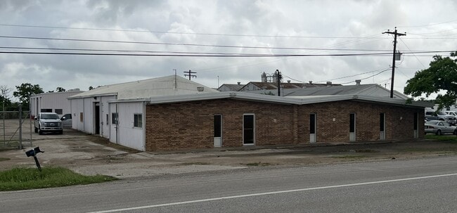


Property Detail
6406 E Highway 332
2113-0121-000
B C I C DIV 13 LOT 193B (A0049 A CALVIT) ACRES 1.00
Commercialnec
BRAZORIA
0380
Texas
B and X Area of moderate flood hazard, usually the area between the limits of the 100-year and 500-year floods.
193b
2024
0.89 AC
2025
South Hwy 35
664200
Houston
8,450 SF
Houston-Pasadena-The Woodlands, TX
NEARBY LISTINGS FOR SALE OR LEASE
DEMOGRAPHICS near 6406 E Highway 332
1 mile
3 mile
5 mile
2025 Total Population
228
15,425
47,174
2030 Population
253
17,477
52,681
Pop Growth 2025-2030
+ 10.96%
+ 13.30%
+ 11.67%
Average Age
35
37
37
2025 Total Households
78
5,725
17,521
HH Growth 2025-2030
+ 10.26%
+ 14.01%
+ 12.14%
Median Household Inc
$41,000
$49,294
$64,075
Avg Household Size
2.90
2.70
2.70
2025 Avg HH Vehicles
1.00
2.00
2.00
Median Home Value
$150,000
$147,603
$212,012
Median Year Built
1979
1979
1981
Nearby Places
Map Layers
Map Styles
 Street
 Aerial
Transit
 Traffic
 Biking
Places
Listings with unknown addresses are not visible on the map
- Restaurants
- Banks
- Shops
- Fitness
- Groceries
SALE & LEASE HISTORY
LISTING DATE
SALE/LEASE

Jul 19, 2024
For Sale
Nearby Properties
Address
Land Use
TOTAL SIZE
Lot Size
Zoning
Address
Land Use
TOTAL SIZE
Lot Size
Zoning
Address
Land Use
TOTAL SIZE
Lot Size
Zoning
Address
Land Use
TOTAL SIZE
Lot Size
Zoning
Address
Land Use
TOTAL SIZE
Lot Size
Zoning
35.50 AC
8680
Address
Land Use
TOTAL SIZE
Lot Size
Zoning
Address
Land Use
TOTAL SIZE
Lot Size
Zoning
Address
Land Use
TOTAL SIZE
Lot Size
Zoning
Address
Land Use
TOTAL SIZE
Lot Size
Zoning
Address
Land Use
TOTAL SIZE
Lot Size
Zoning
320,260 SF
31.88 AC
Address
Land Use
TOTAL SIZE
Lot Size
Zoning
33.09 AC
0050
Address
Land Use
TOTAL SIZE
Lot Size
Zoning
61.70 AC
Address
Land Use
TOTAL SIZE
Lot Size
Zoning
Address
Land Use
TOTAL SIZE
Lot Size
Zoning
Address
Land Use
TOTAL SIZE
Lot Size
Zoning
Address
Land Use
TOTAL SIZE
Lot Size
Zoning
Address
Land Use
TOTAL SIZE
Lot Size
Zoning
242.03 AC
0275
Address
Land Use
TOTAL SIZE
Lot Size
Zoning
Address
Land Use
TOTAL SIZE
Lot Size
Zoning
4.27 AC
0170
Address
Land Use
TOTAL SIZE
Lot Size
Zoning
188,497 SF
14.79 AC
1135
Address
Land Use
TOTAL SIZE
Lot Size
Zoning
145,222 SF
7.25 AC
0109
Address
Land Use
TOTAL SIZE
Lot Size
Zoning
216,802 SF
11.49 AC
Address
Land Use
TOTAL SIZE
Lot Size
Zoning
Address
Land Use
TOTAL SIZE
Lot Size
Zoning
75.99 AC
0410
Address
Land Use
TOTAL SIZE
Lot Size
Zoning
Address
Land Use
TOTAL SIZE
Lot Size
Zoning
122,989 SF
22.98 AC
0211
Address
Land Use
TOTAL SIZE
Lot Size
Zoning
128,282 SF
4.39 AC
0001
Address
Land Use
TOTAL SIZE
Lot Size
Zoning
Address
Land Use
TOTAL SIZE
Lot Size
Zoning
24.81 AC
0031
Address
Land Use
TOTAL SIZE
Lot Size
Zoning
48,773 SF
Address
Land Use
TOTAL SIZE
Lot Size
Zoning
1.75 AC
The World's #1 Commercial Real Estate Marketplace
Connect with us
© 2026 CoStar Group
The information above has been obtained from sources believed reliable. While we do not doubt its accuracy we have not verified it and make no guarantee, warranty or representation about it. It is your responsibility to independently confirm its accuracy and completeness. Any projections, opinions, assumptions, or estimates used are for example only and do not represent the current or future performance of the property. The value of this transaction to you depends on tax and other factors which should be evaluated by your tax, financial, and legal advisors. You and your advisors should conduct a careful, independent investigation of the property to determine to your satisfaction the suitability of the property for your needs.