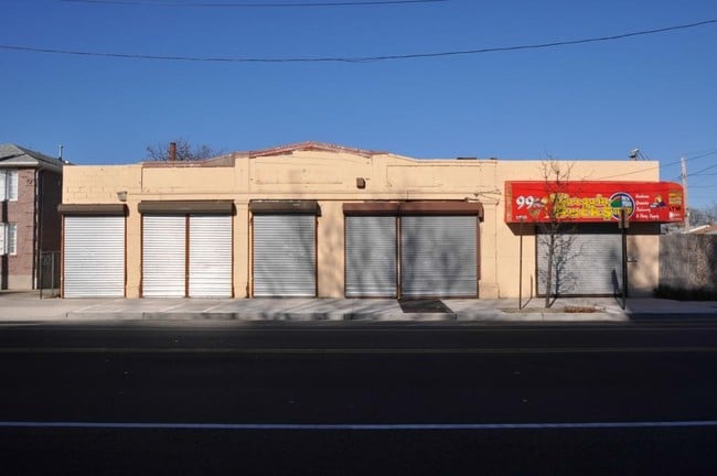
Property Record
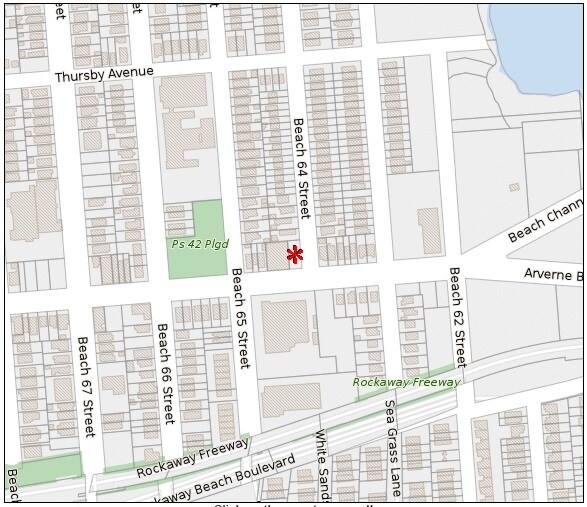
6408 Beach Channel Dr, Arverne, NY 11692

NEARBY LISTINGS FOR SALE OR LEASE
Property Detail
6408 Beach Channel Dr
16038-0070
Queens
Industrialgeneral
New York
AE
68
3604970383F
0.18 AC
2024
South Queens
2025
Long Island (New York)
096400
New York-Jersey City-White Plains, NY-NJ
6,810 SF
DEMOGRAPHICS near 6408 Beach Channel Dr
1 Mile
3 Mile
5 Mile
2024 Total Population
28,988
112,945
168,091
2029 Population
26,988
106,354
159,386
Pop Growth 2024-2029
(6.90%)
(5.84%)
(5.18%)
Average Age
39
40
40
2024 Total Households
10,144
39,572
56,857
HH Growth 2024-2029
(7.25%)
(5.85%)
(5.31%)
Median Household Inc
$44,747
$53,910
$67,773
Avg Household Size
2.60
2.60
2.70
2024 Avg HH Vehicles
1.00
1.00
1.00
Median Home Value
$496,890
$596,866
$716,836
Median Year Built
1969
1965
1961
Nearby Places
- Restaurants
- Banks
- Shops
- Fitness
- Groceries
PUBLIC TRANSPORTATION
TRANSIT/SUBWAY
Beach 67 Street (A - New York MTA Subway (The Subway))
DRIVE
WALK
Distance
Beach 67 Street (A - New York MTA Subway (The Subway))
1 min
6 min
0.3 mi
Beach 60 Street (A - New York MTA Subway (The Subway))
DRIVE
WALK
Distance
Beach 60 Street (A - New York MTA Subway (The Subway))
1 min
6 min
0.3 mi
Beach 44 Street (A - New York MTA Subway (The Subway))
DRIVE
WALK
Distance
Beach 44 Street (A - New York MTA Subway (The Subway))
3 min
19 min
1.0 mi
COMMUTER RAIL
Far Rockaway Station (Far Rockaway Branch - Long Island Rail Road)
DRIVE
WALK
Distance
Far Rockaway Station (Far Rockaway Branch - Long Island Rail Road)
8 min
2.8 mi
Inwood Station (Far Rockaway Branch - Long Island Rail Road)
DRIVE
WALK
Distance
Inwood Station (Far Rockaway Branch - Long Island Rail Road)
9 min
4.1 mi
AIRPORT
John F Kennedy International
DRIVE
WALK
Distance
John F Kennedy International
25 min
10.9 mi
LaGuardia
DRIVE
WALK
Distance
LaGuardia
35 min
17.9 mi
Newark Liberty International
DRIVE
WALK
Distance
Newark Liberty International
60 min
29.4 mi
Freight Ports
NY - Red Hook Container Terminal
DRIVE
WALK
Distance
NY - Red Hook Container Terminal
39 min
17.6 mi
SALE & LEASE HISTORY
LISTING DATE
SALE/LEASE

Mar 03, 2017
For Sale
Jan 31, 2017
For Sale
Dec 10, 2019
For Lease
Nearby Properties
Address
Land Use
TOTAL SIZE
Lot Size
Zoning
Address
Land Use
TOTAL SIZE
Lot Size
Zoning
229.51 AC
PARKUS
Address
Land Use
TOTAL SIZE
Lot Size
Zoning
111.98 AC
PARK
Address
Land Use
TOTAL SIZE
Lot Size
Zoning
72,663 SF
264.48 AC
PARK
Address
Land Use
TOTAL SIZE
Lot Size
Zoning
200.83 AC
PARK
Address
Land Use
TOTAL SIZE
Lot Size
Zoning
42.84 AC
PARK
Address
Land Use
TOTAL SIZE
Lot Size
Zoning
60.84 AC
R4
Address
Land Use
TOTAL SIZE
Lot Size
Zoning
169.01 AC
PARK
Address
Land Use
TOTAL SIZE
Lot Size
Zoning
1,085,148 SF
13.53 AC
R6
Address
Land Use
TOTAL SIZE
Lot Size
Zoning
407,218 SF
34.48 AC
R4
Address
Land Use
TOTAL SIZE
Lot Size
Zoning
52.80 AC
PARK
Address
Land Use
TOTAL SIZE
Lot Size
Zoning
32.47 AC
PARK
Address
Land Use
TOTAL SIZE
Lot Size
Zoning
188,656 SF
5.78 AC
R5
Address
Land Use
TOTAL SIZE
Lot Size
Zoning
820,910 SF
21.03 AC
R4
Address
Land Use
TOTAL SIZE
Lot Size
Zoning
188.92 AC
PARK
Address
Land Use
TOTAL SIZE
Lot Size
Zoning
17.68 AC
PARK
Address
Land Use
TOTAL SIZE
Lot Size
Zoning
661,319 SF
50.43 AC
R5
Address
Land Use
TOTAL SIZE
Lot Size
Zoning
1,800 SF
65.66 AC
PARK
Address
Land Use
TOTAL SIZE
Lot Size
Zoning
587,170 SF
13.55 AC
R4
Address
Land Use
TOTAL SIZE
Lot Size
Zoning
14.91 AC
C4-4
Address
Land Use
TOTAL SIZE
Lot Size
Zoning
154,051 SF
4.05 AC
R5
Address
Land Use
TOTAL SIZE
Lot Size
Zoning
119,788 SF
3.90 AC
R5
Address
Land Use
TOTAL SIZE
Lot Size
Zoning
160,315 SF
0.66 AC
R7A
Address
Land Use
TOTAL SIZE
Lot Size
Zoning
72,148 SF
0.44 AC
R6A
Address
Land Use
TOTAL SIZE
Lot Size
Zoning
449,000 SF
5.15 AC
R6
Address
Land Use
TOTAL SIZE
Lot Size
Zoning
128,000 SF
2.52 AC
R5
Address
Land Use
TOTAL SIZE
Lot Size
Zoning
666,256 SF
14.16 AC
R6
Address
Land Use
TOTAL SIZE
Lot Size
Zoning
155,875 SF
0.90 AC
R6
Address
Land Use
TOTAL SIZE
Lot Size
Zoning
145,883 SF
1.29 AC
R6
Address
Land Use
TOTAL SIZE
Lot Size
Zoning
3,120 SF
20.62 AC
PARK
Address
Land Use
TOTAL SIZE
Lot Size
Zoning
120,994 SF
1.71 AC
R6
The World's #1 Commercial Real Estate Marketplace
Connect with us
© 2025 CoStar Group
The information above has been obtained from sources believed reliable. While we do not doubt its accuracy we have not verified it and make no guarantee, warranty or representation about it. It is your responsibility to independently confirm its accuracy and completeness. Any projections, opinions, assumptions, or estimates used are for example only and do not represent the current or future performance of the property. The value of this transaction to you depends on tax and other factors which should be evaluated by your tax, financial, and legal advisors. You and your advisors should conduct a careful, independent investigation of the property to determine to your satisfaction the suitability of the property for your needs.