Property Record
6408 Harding Hwy, Mays Landing, NJ 08330


NEARBY LISTINGS FOR SALE OR LEASE
-
-
View all Mays Landing listings for sale on LoopNet.com
Property Detail
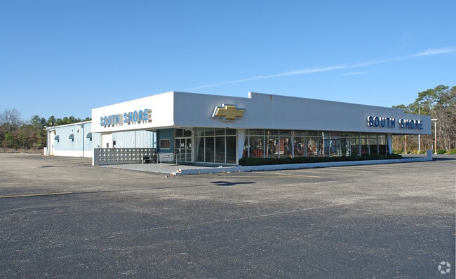
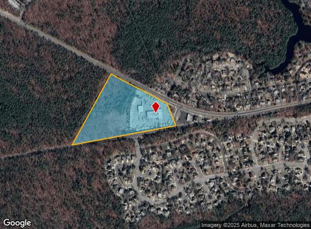
6408 Harding Hwy
12-00670-0000-00004
Atlantic
Vehiclerentalsvehiclesales
New Jersey
X
4
34001C0259F
12.98 AC
2024
Atlantic City/Hammonton
2025
Philadelphia
011500
Atlantic City-Hammonton, NJ
10,902 SF
DEMOGRAPHICS near 6408 Harding Hwy
1 Mile
3 Mile
5 Mile
2024 Total Population
2,338
7,950
14,127
2029 Population
2,285
7,806
13,842
Pop Growth 2024-2029
(2.27%)
(1.81%)
(2.02%)
Average Age
38
43
42
2024 Total Households
824
3,030
5,208
HH Growth 2024-2029
(2.79%)
(2.41%)
(2.71%)
Median Household Inc
$71,145
$73,849
$76,455
Avg Household Size
2.70
2.50
2.50
2024 Avg HH Vehicles
2.00
2.00
2.00
Median Home Value
$187,091
$205,918
$228,085
Median Year Built
1968
1977
1982
Nearby Places
Map Layers
Map Styles
 Street
 Aerial
- Restaurants
- Banks
- Shops
- Fitness
- Groceries
PUBLIC TRANSPORTATION
COMMUTER RAIL
Egg Harbor City (Atlantic City Line - NJ Transit Commuter Rail (NJ Transit))
DRIVE
WALK
Distance
Egg Harbor City (Atlantic City Line - NJ Transit Commuter Rail (NJ Transit))
15 min
8.9 mi
AIRPORT
Atlantic City International
DRIVE
WALK
Distance
Atlantic City International
39 min
14.0 mi
Freight Ports
Broadway Terminal - Pier 5
DRIVE
WALK
Distance
Broadway Terminal - Pier 5
59 min
42.3 mi
Nearby Properties
Address
Land Use
TOTAL SIZE
Lot Size
Zoning
Address
Land Use
TOTAL SIZE
Lot Size
Zoning
622 SF
142.51 AC
PFMH
Address
Land Use
TOTAL SIZE
Lot Size
Zoning
71,556 SF
7.13 AC
R-9
Address
Land Use
TOTAL SIZE
Lot Size
Zoning
3,138 SF
12.26 AC
RD-5
Address
Land Use
TOTAL SIZE
Lot Size
Zoning
59,362 SF
3.47 AC
R-9
Address
Land Use
TOTAL SIZE
Lot Size
Zoning
1.14 AC
GC
Address
Land Use
TOTAL SIZE
Lot Size
Zoning
10.41 AC
DC
Address
Land Use
TOTAL SIZE
Lot Size
Zoning
98.86 AC
IBP
Address
Land Use
TOTAL SIZE
Lot Size
Zoning
24,925 SF
8.89 AC
IBP
Address
Land Use
TOTAL SIZE
Lot Size
Zoning
11.08 AC
IBP
Address
Land Use
TOTAL SIZE
Lot Size
Zoning
2,944 SF
29.83 AC
GA-L
Address
Land Use
TOTAL SIZE
Lot Size
Zoning
728 SF
14.84 AC
R-22
Address
Land Use
TOTAL SIZE
Lot Size
Zoning
14,784 SF
15.42 AC
GA-L
Address
Land Use
TOTAL SIZE
Lot Size
Zoning
5.37 AC
C
Address
Land Use
TOTAL SIZE
Lot Size
Zoning
1,188 SF
79 AC
R-10
Address
Land Use
TOTAL SIZE
Lot Size
Zoning
3,190 SF
2.11 AC
R-9
Address
Land Use
TOTAL SIZE
Lot Size
Zoning
20,981 SF
2.05 AC
G-C
Address
Land Use
TOTAL SIZE
Lot Size
Zoning
9,354 SF
3.39 AC
GA-M
Address
Land Use
TOTAL SIZE
Lot Size
Zoning
12,000 SF
2.02 AC
IBP
Address
Land Use
TOTAL SIZE
Lot Size
Zoning
30,000 SF
2.98 AC
IBP
Address
Land Use
TOTAL SIZE
Lot Size
Zoning
20,472 SF
3.27 AC
GC
Address
Land Use
TOTAL SIZE
Lot Size
Zoning
17,143 SF
1.34 AC
GC
Address
Land Use
TOTAL SIZE
Lot Size
Zoning
9,310 SF
13.27 AC
IBP
Address
Land Use
TOTAL SIZE
Lot Size
Zoning
1,560 SF
12 AC
R-25
Address
Land Use
TOTAL SIZE
Lot Size
Zoning
4.79 AC
R-22
Address
Land Use
TOTAL SIZE
Lot Size
Zoning
7,236 SF
0.51 AC
VC
Address
Land Use
TOTAL SIZE
Lot Size
Zoning
4,564 SF
482.05 AC
FA70
Address
Land Use
TOTAL SIZE
Lot Size
Zoning
20,052 SF
2.98 AC
IBP
Address
Land Use
TOTAL SIZE
Lot Size
Zoning
3,939 SF
1.09 AC
GC
Address
Land Use
TOTAL SIZE
Lot Size
Zoning
3.34 AC
GA-L
The World's #1 Commercial Real Estate Marketplace
Connect with us
© 2026 CoStar Group
The information above has been obtained from sources believed reliable. While we do not doubt its accuracy we have not verified it and make no guarantee, warranty or representation about it. It is your responsibility to independently confirm its accuracy and completeness. Any projections, opinions, assumptions, or estimates used are for example only and do not represent the current or future performance of the property. The value of this transaction to you depends on tax and other factors which should be evaluated by your tax, financial, and legal advisors. You and your advisors should conduct a careful, independent investigation of the property to determine to your satisfaction the suitability of the property for your needs.