Property Record
6409 Springdale Rd, Austin, TX 78723
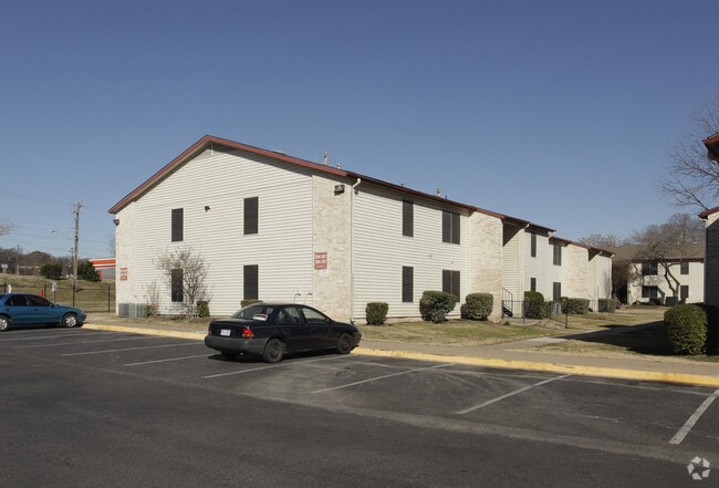


Property Detail
6409 Springdale Rd
219376
ACR 7.602 WALNUT CREEK APARTMENTS SUBD
Multifamilydwelling
Travis
AE The base floodplain where base flood elevations are provided. AE Zones are now used on new format FIRMs instead of A1-A30 Zones.
Texas
2025
7.60 AC
2025
Walnut Creek Greenbelt
002108
Austin
81,440 SF
Austin-Round Rock-San Marcos, TX
NEARBY LISTINGS FOR SALE OR LEASE
DEMOGRAPHICS near 6409 Springdale Rd
1 mile
3 mile
5 mile
2025 Total Population
12,302
101,232
290,852
2030 Population
12,999
106,949
306,379
Pop Growth 2025-2030
+ 5.67%
+ 5.65%
+ 5.34%
Average Age
39
36
35
2025 Total Households
4,737
39,152
118,322
HH Growth 2025-2030
+ 6.38%
+ 6.26%
+ 6.17%
Median Household Inc
$101,951
$81,921
$76,879
Avg Household Size
2.50
2.40
2.30
2025 Avg HH Vehicles
2.00
2.00
2.00
Median Home Value
$568,759
$536,736
$586,030
Median Year Built
1977
1991
1992
Nearby Places
Map Layers
Map Styles
 Street
 Aerial
Transit
 Traffic
 Biking
Places
Listings with unknown addresses are not visible on the map
- Restaurants
- Banks
- Shops
- Fitness
- Groceries
PUBLIC TRANSPORTATION
COMMUTER RAIL
Austin (Texas Eagle - Amtrak)
Drive
Walk
Distance
Austin (Texas Eagle - Amtrak)
14 min
7.1 mi
AIRPORT
Austin-Bergstrom International
Drive
Walk
Distance
Austin-Bergstrom International
23 min
13.2 mi
Freight Ports
Calhoun Port
Drive
Walk
Distance
Calhoun Port
189 min
156.7 mi
Nearby Properties
Address
Land Use
TOTAL SIZE
Lot Size
Zoning
Address
Land Use
TOTAL SIZE
Lot Size
Zoning
548,399 SF
23.82 AC
Address
Land Use
TOTAL SIZE
Lot Size
Zoning
19,284 SF
178.26 AC
Address
Land Use
TOTAL SIZE
Lot Size
Zoning
241,998 SF
2.42 AC
Address
Land Use
TOTAL SIZE
Lot Size
Zoning
480,823 SF
18.46 AC
Address
Land Use
TOTAL SIZE
Lot Size
Zoning
322,150 SF
3.83 AC
Address
Land Use
TOTAL SIZE
Lot Size
Zoning
432,032 SF
6.70 AC
Address
Land Use
TOTAL SIZE
Lot Size
Zoning
609,823 SF
3.33 AC
Address
Land Use
TOTAL SIZE
Lot Size
Zoning
372,075 SF
4.97 AC
Address
Land Use
TOTAL SIZE
Lot Size
Zoning
265,000 SF
1.57 AC
Address
Land Use
TOTAL SIZE
Lot Size
Zoning
297,356 SF
4.32 AC
Address
Land Use
TOTAL SIZE
Lot Size
Zoning
283,800 SF
4.05 AC
Address
Land Use
TOTAL SIZE
Lot Size
Zoning
288,750 SF
4.81 AC
Address
Land Use
TOTAL SIZE
Lot Size
Zoning
425,200 SF
2.49 AC
Address
Land Use
TOTAL SIZE
Lot Size
Zoning
126.15 AC
Address
Land Use
TOTAL SIZE
Lot Size
Zoning
274,943 SF
42.35 AC
Address
Land Use
TOTAL SIZE
Lot Size
Zoning
250,800 SF
12.41 AC
Address
Land Use
TOTAL SIZE
Lot Size
Zoning
236,688 SF
3.64 AC
Address
Land Use
TOTAL SIZE
Lot Size
Zoning
376,385 SF
26.47 AC
Address
Land Use
TOTAL SIZE
Lot Size
Zoning
84,920 SF
74.13 AC
Address
Land Use
TOTAL SIZE
Lot Size
Zoning
555,296 SF
4.07 AC
Address
Land Use
TOTAL SIZE
Lot Size
Zoning
278,429 SF
3.76 AC
Address
Land Use
TOTAL SIZE
Lot Size
Zoning
306,658 SF
9.49 AC
Address
Land Use
TOTAL SIZE
Lot Size
Zoning
76,454 SF
199.64 AC
Address
Land Use
TOTAL SIZE
Lot Size
Zoning
115,640 SF
18 AC
Address
Land Use
TOTAL SIZE
Lot Size
Zoning
274,864 SF
3.33 AC
Address
Land Use
TOTAL SIZE
Lot Size
Zoning
278,100 SF
3.55 AC
Address
Land Use
TOTAL SIZE
Lot Size
Zoning
320,797 SF
12.04 AC
Address
Land Use
TOTAL SIZE
Lot Size
Zoning
266,475 SF
2.34 AC
Address
Land Use
TOTAL SIZE
Lot Size
Zoning
252,450 SF
2.72 AC
Address
Land Use
TOTAL SIZE
Lot Size
Zoning
148,390 SF
15.86 AC
The World's #1 Commercial Real Estate Marketplace
Connect with us
© 2026 CoStar Group
The information above has been obtained from sources believed reliable. While we do not doubt its accuracy we have not verified it and make no guarantee, warranty or representation about it. It is your responsibility to independently confirm its accuracy and completeness. Any projections, opinions, assumptions, or estimates used are for example only and do not represent the current or future performance of the property. The value of this transaction to you depends on tax and other factors which should be evaluated by your tax, financial, and legal advisors. You and your advisors should conduct a careful, independent investigation of the property to determine to your satisfaction the suitability of the property for your needs.