Property Record
641 Main St, Weaverville, CA 96093


Save to a Folder
{{folder.Name}}
{{folder.ListingIds.length}} Properties
{{folder.ListingIds.length}} Property
Create a New Folder
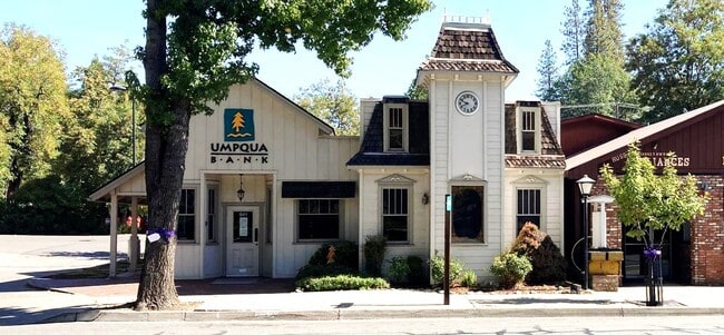
Property Detail
641 Main St
Officebuilding
TRINITY
C
California
AO River or stream flood hazard areas, and areas with a 1% or greater chance of shallow flooding each year. These areas have a 26% chance of flooding over the life of a 30-year mortgage.
0.17 AC
2024
California North Rural Area
2025
Other Market Areas
000102
001-150-023-000
2,138 SF
NEARBY LISTINGS FOR SALE OR LEASE
-
-
View all Weaverville listings for lease on LoopNet.com
DEMOGRAPHICS near 641 Main St
1 mile
3 mile
5 mile
2025 Total Population
2,386
3,428
3,826
2030 Population
2,308
3,318
3,703
Pop Growth 2025-2030
(3.27%)
(3.21%)
(3.21%)
Average Age
43
43
44
2025 Total Households
993
1,451
1,639
HH Growth 2025-2030
(2.82%)
(2.76%)
(2.81%)
Median Household Inc
$74,582
$70,730
$67,826
Avg Household Size
2.30
2.30
2.30
2025 Avg HH Vehicles
2.00
2.00
2.00
Median Home Value
$378,378
$368,749
$371,207
Median Year Built
1973
1975
1975
Nearby Places
Map Layers
Map Styles
 Street
 Aerial
Layers
 Traffic
 Biking
Places
Listings with unknown addresses are not visible on the map
- Restaurants
- Banks
- Shops
- Fitness
- Groceries
SALE & LEASE HISTORY
LISTING DATE
SALE/LEASE

Oct 21, 2021
For Sale
Apr 11, 2025
For Lease
Nearby Properties
Address
Land Use
TOTAL SIZE
Lot Size
Zoning
Address
Land Use
TOTAL SIZE
Lot Size
Zoning
113.24 AC
I
Address
Land Use
TOTAL SIZE
Lot Size
Zoning
2.17 AC
C
Address
Land Use
TOTAL SIZE
Lot Size
Zoning
38,790 SF
3.67 AC
C
Address
Land Use
TOTAL SIZE
Lot Size
Zoning
23,100 SF
2.96 AC
C
Address
Land Use
TOTAL SIZE
Lot Size
Zoning
5,822 SF
0.69 AC
C
Address
Land Use
TOTAL SIZE
Lot Size
Zoning
9,100 SF
1.11 AC
C
Address
Land Use
TOTAL SIZE
Lot Size
Zoning
160 SF
0.50 AC
Address
Land Use
TOTAL SIZE
Lot Size
Zoning
22,865 SF
2.38 AC
C
Address
Land Use
TOTAL SIZE
Lot Size
Zoning
3.04 AC
C
Address
Land Use
TOTAL SIZE
Lot Size
Zoning
1,224 SF
0.59 AC
C
Address
Land Use
TOTAL SIZE
Lot Size
Zoning
11,278 SF
3.13 AC
C
Address
Land Use
TOTAL SIZE
Lot Size
Zoning
16,390 SF
0.63 AC
MFH
Address
Land Use
TOTAL SIZE
Lot Size
Zoning
4,979 SF
0.37 AC
C
Address
Land Use
TOTAL SIZE
Lot Size
Zoning
32,724 SF
1.88 AC
MFH
Address
Land Use
TOTAL SIZE
Lot Size
Zoning
2,894 SF
0.55 AC
C
Address
Land Use
TOTAL SIZE
Lot Size
Zoning
5,592 SF
2.66 AC
C
Address
Land Use
TOTAL SIZE
Lot Size
Zoning
6,602 SF
0.78 AC
MFM
Address
Land Use
TOTAL SIZE
Lot Size
Zoning
5,415 SF
1.24 AC
C
Address
Land Use
TOTAL SIZE
Lot Size
Zoning
10,348 SF
0.83 AC
C
Address
Land Use
TOTAL SIZE
Lot Size
Zoning
4,801 SF
1.70 AC
C
Address
Land Use
TOTAL SIZE
Lot Size
Zoning
1.93 AC
C
Address
Land Use
TOTAL SIZE
Lot Size
Zoning
12,800 SF
8.12 AC
SFL
Address
Land Use
TOTAL SIZE
Lot Size
Zoning
6,592 SF
1.09 AC
C
Address
Land Use
TOTAL SIZE
Lot Size
Zoning
17,504 SF
1.10 AC
MFH
Address
Land Use
TOTAL SIZE
Lot Size
Zoning
9,314 SF
3 AC
PF
Address
Land Use
TOTAL SIZE
Lot Size
Zoning
468 SF
0.33 AC
C
Address
Land Use
TOTAL SIZE
Lot Size
Zoning
6,800 SF
0.79 AC
C
Address
Land Use
TOTAL SIZE
Lot Size
Zoning
0.68 AC
C
Address
Land Use
TOTAL SIZE
Lot Size
Zoning
5,452 SF
1.22 AC
PF
Address
Land Use
TOTAL SIZE
Lot Size
Zoning
8,362 SF
0.73 AC
C
The World's #1 Commercial Real Estate Marketplace
Connect with us
© 2026 CoStar Group
The information above has been obtained from sources believed reliable. While we do not doubt its accuracy we have not verified it and make no guarantee, warranty or representation about it. It is your responsibility to independently confirm its accuracy and completeness. Any projections, opinions, assumptions, or estimates used are for example only and do not represent the current or future performance of the property. The value of this transaction to you depends on tax and other factors which should be evaluated by your tax, financial, and legal advisors. You and your advisors should conduct a careful, independent investigation of the property to determine to your satisfaction the suitability of the property for your needs.