Property Record
641 Middle St, Middletown, CT 06457
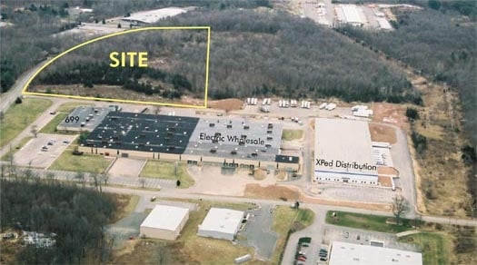

Property Detail
641 Middle St
MTWN-000002-000000-000340
Lower Ct River Vly
Industrialgeneral
Connecticut
IT
340
B and X Area of moderate flood hazard, usually the area between the limits of the 100-year and 500-year floods.
26.91 AC
2024
NW Middlesex/Mid'town
2025
Hartford
541401
Hartford-West Hartford-East Hartford, CT
197,680 SF
NEARBY LISTINGS FOR SALE OR LEASE
DEMOGRAPHICS near 641 Middle St
1 mile
3 mile
5 mile
2025 Total Population
3,158
28,513
105,324
2030 Population
3,173
28,727
106,476
Pop Growth 2025-2030
+ 0.47%
+ 0.75%
+ 1.09%
Average Age
39
42
41
2025 Total Households
1,468
12,505
43,639
HH Growth 2025-2030
+ 0.41%
+ 0.69%
+ 1.07%
Median Household Inc
$90,823
$89,099
$82,989
Avg Household Size
2.10
2.20
2.30
2025 Avg HH Vehicles
2.00
2.00
2.00
Median Home Value
$348,214
$345,983
$314,964
Median Year Built
1984
1982
1972
Nearby Places
Map Layers
Map Styles
 Street
 Aerial
Transit
 Traffic
 Biking
Places
Listings with unknown addresses are not visible on the map
- Restaurants
- Banks
- Shops
- Fitness
- Groceries
PUBLIC TRANSPORTATION
COMMUTER RAIL
Drive
Walk
Distance
12 min
5.0 mi
Drive
Walk
Distance
13 min
5.0 mi
AIRPORT
Tweed/New Haven
Drive
Walk
Distance
Tweed/New Haven
43 min
27.0 mi
Bradley International
Drive
Walk
Distance
Bradley International
47 min
29.9 mi
Freight Ports
Port of New Haven
Drive
Walk
Distance
Port of New Haven
38 min
25.8 mi
Nearby Properties
Address
Land Use
TOTAL SIZE
Lot Size
Zoning
Address
Land Use
TOTAL SIZE
Lot Size
Zoning
17.38 AC
PRD
Address
Land Use
TOTAL SIZE
Lot Size
Zoning
29.45 AC
R-15
Address
Land Use
TOTAL SIZE
Lot Size
Zoning
27.21 AC
M
Address
Land Use
TOTAL SIZE
Lot Size
Zoning
241,225 SF
25.64 AC
R-11
Address
Land Use
TOTAL SIZE
Lot Size
Zoning
15.10 AC
PRD
Address
Land Use
TOTAL SIZE
Lot Size
Zoning
19.49 AC
PRD
Address
Land Use
TOTAL SIZE
Lot Size
Zoning
11.81 AC
PRD
Address
Land Use
TOTAL SIZE
Lot Size
Zoning
27,152 SF
8.75 AC
R-25
Address
Land Use
TOTAL SIZE
Lot Size
Zoning
24.45 AC
HB
Address
Land Use
TOTAL SIZE
Lot Size
Zoning
129,626 SF
22.36 AC
IT
Address
Land Use
TOTAL SIZE
Lot Size
Zoning
13.28 AC
PRD
Address
Land Use
TOTAL SIZE
Lot Size
Zoning
83,241 SF
52.65 AC
R-15
Address
Land Use
TOTAL SIZE
Lot Size
Zoning
41.78 AC
IT
Address
Land Use
TOTAL SIZE
Lot Size
Zoning
15.50 AC
PRD
Address
Land Use
TOTAL SIZE
Lot Size
Zoning
91,663 SF
22.20 AC
R-21
Address
Land Use
TOTAL SIZE
Lot Size
Zoning
80,627 SF
10.54 AC
HB
Address
Land Use
TOTAL SIZE
Lot Size
Zoning
5.65 AC
HB
Address
Land Use
TOTAL SIZE
Lot Size
Zoning
13.02 AC
HB
Address
Land Use
TOTAL SIZE
Lot Size
Zoning
67,050 SF
20.36 AC
R-15
Address
Land Use
TOTAL SIZE
Lot Size
Zoning
14.65 AC
M
Address
Land Use
TOTAL SIZE
Lot Size
Zoning
50,533 SF
33 AC
R-30
Address
Land Use
TOTAL SIZE
Lot Size
Zoning
6.09 AC
PRD
Address
Land Use
TOTAL SIZE
Lot Size
Zoning
72,920 SF
4.10 AC
HB
Address
Land Use
TOTAL SIZE
Lot Size
Zoning
122,735 SF
16.85 AC
HB
Address
Land Use
TOTAL SIZE
Lot Size
Zoning
49,228 SF
164.74 AC
R-1
Address
Land Use
TOTAL SIZE
Lot Size
Zoning
50,273 SF
16.20 AC
R-15
Address
Land Use
TOTAL SIZE
Lot Size
Zoning
228,928 SF
16.24 AC
IT
Address
Land Use
TOTAL SIZE
Lot Size
Zoning
156,397 SF
28 AC
HB
Address
Land Use
TOTAL SIZE
Lot Size
Zoning
96,874 SF
6.40 AC
IOP
The World's #1 Commercial Real Estate Marketplace
Connect with us
© 2026 CoStar Group
The information above has been obtained from sources believed reliable. While we do not doubt its accuracy we have not verified it and make no guarantee, warranty or representation about it. It is your responsibility to independently confirm its accuracy and completeness. Any projections, opinions, assumptions, or estimates used are for example only and do not represent the current or future performance of the property. The value of this transaction to you depends on tax and other factors which should be evaluated by your tax, financial, and legal advisors. You and your advisors should conduct a careful, independent investigation of the property to determine to your satisfaction the suitability of the property for your needs.