Property Record
Richmond Rd, Richmond Heights, OH 44143


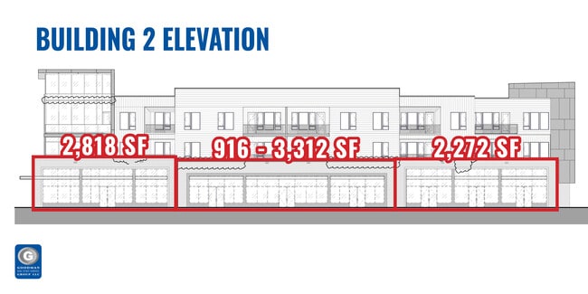
Current Lease Availabilities
NEARBY LISTINGS FOR SALE OR LEASE
-
-
View all Richmond Heights listings for lease on LoopNet.com
Property Detail
Richmond Rd
Cleveland-Elyria, OH
PARCEL B-7 AFN202301240517
662-30-127
Cuyahoga
Publicstorage
Ohio
2024
2.28 AC
2024
Northeast
155101
Cleveland
164,864 SF
DEMOGRAPHICS near Richmond Rd
1 Mile
3 Mile
5 Mile
2024 Total Population
8,162
86,741
242,684
2029 Population
8,028
86,042
242,410
Pop Growth 2024-2029
(1.64%)
(0.81%)
(0.11%)
Average Age
46
43
42
2024 Total Households
3,459
37,838
107,144
HH Growth 2024-2029
(1.71%)
(0.84%)
(0.18%)
Median Household Inc
$84,054
$75,084
$61,096
Avg Household Size
2.30
2.20
2.20
2024 Avg HH Vehicles
2.00
2.00
1.00
Median Home Value
$228,921
$185,864
$183,022
Median Year Built
1963
1958
1955
Nearby Places
Map Layers
Map Styles
 Street
 Aerial
- Restaurants
- Banks
- Shops
- Fitness
- Groceries
PUBLIC TRANSPORTATION
AIRPORT
Cleveland-Hopkins International
DRIVE
WALK
Distance
Cleveland-Hopkins International
45 min
28.3 mi
Freight Ports
Port of Toledo
DRIVE
WALK
Distance
Port of Toledo
159 min
129.2 mi
Nearby Properties
Address
Land Use
TOTAL SIZE
Lot Size
Zoning
Address
Land Use
TOTAL SIZE
Lot Size
Zoning
964,082 SF
40.67 AC
Address
Land Use
TOTAL SIZE
Lot Size
Zoning
650,536 SF
19.01 AC
U-3A
Address
Land Use
TOTAL SIZE
Lot Size
Zoning
379,326 SF
43.45 AC
CRG
Address
Land Use
TOTAL SIZE
Lot Size
Zoning
157,311 SF
8.95 AC
U-1A
Address
Land Use
TOTAL SIZE
Lot Size
Zoning
302,009 SF
6.62 AC
U-7A
Address
Land Use
TOTAL SIZE
Lot Size
Zoning
384,659 SF
20.20 AC
U-4A
Address
Land Use
TOTAL SIZE
Lot Size
Zoning
106,995 SF
9.62 AC
CRG
Address
Land Use
TOTAL SIZE
Lot Size
Zoning
252,759 SF
27.66 AC
R-1
Address
Land Use
TOTAL SIZE
Lot Size
Zoning
1,520,349 SF
20.39 AC
IR
Address
Land Use
TOTAL SIZE
Lot Size
Zoning
92,442 SF
159.84 AC
I-1
Address
Land Use
TOTAL SIZE
Lot Size
Zoning
166,392 SF
36.46 AC
RMF-2
Address
Land Use
TOTAL SIZE
Lot Size
Zoning
91,540 SF
14.35 AC
CRG
Address
Land Use
TOTAL SIZE
Lot Size
Zoning
190,580 SF
7.90 AC
P.F.
Address
Land Use
TOTAL SIZE
Lot Size
Zoning
2.53 AC
U6
Address
Land Use
TOTAL SIZE
Lot Size
Zoning
65,612 SF
6.01 AC
U-4
Address
Land Use
TOTAL SIZE
Lot Size
Zoning
628,514 SF
25.95 AC
B-2
Address
Land Use
TOTAL SIZE
Lot Size
Zoning
100,469 SF
25.96 AC
AA
Address
Land Use
TOTAL SIZE
Lot Size
Zoning
57,762 SF
10.80 AC
U-1
Address
Land Use
TOTAL SIZE
Lot Size
Zoning
255,964 SF
39.41 AC
R-75
Address
Land Use
TOTAL SIZE
Lot Size
Zoning
275,040 SF
9.07 AC
U3
Address
Land Use
TOTAL SIZE
Lot Size
Zoning
628,514 SF
0.67 AC
B-2
Address
Land Use
TOTAL SIZE
Lot Size
Zoning
0.23 AC
P-C-M
Address
Land Use
TOTAL SIZE
Lot Size
Zoning
157,761 SF
14.27 AC
R-50
Address
Land Use
TOTAL SIZE
Lot Size
Zoning
175,620 SF
8.65 AC
M
Address
Land Use
TOTAL SIZE
Lot Size
Zoning
89,347 SF
1.10 AC
CRG
Address
Land Use
TOTAL SIZE
Lot Size
Zoning
208,610 SF
7.54 AC
M
Address
Land Use
TOTAL SIZE
Lot Size
Zoning
186,262 SF
5.06 AC
U-4A
Address
Land Use
TOTAL SIZE
Lot Size
Zoning
61,352 SF
10.79 AC
M-I
Address
Land Use
TOTAL SIZE
Lot Size
Zoning
429,565 SF
18 AC
P-C-M
Address
Land Use
TOTAL SIZE
Lot Size
Zoning
111,800 SF
8 AC
1F-4
The World's #1 Commercial Real Estate Marketplace
Connect with us
© 2025 CoStar Group
The information above has been obtained from sources believed reliable. While we do not doubt its accuracy we have not verified it and make no guarantee, warranty or representation about it. It is your responsibility to independently confirm its accuracy and completeness. Any projections, opinions, assumptions, or estimates used are for example only and do not represent the current or future performance of the property. The value of this transaction to you depends on tax and other factors which should be evaluated by your tax, financial, and legal advisors. You and your advisors should conduct a careful, independent investigation of the property to determine to your satisfaction the suitability of the property for your needs.