Property Record
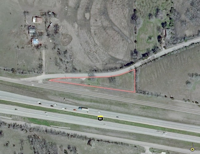
641 Us Highway 80 E, Sunnyvale, TX 75182

Property Detail
641 Us Highway 80 E
65033050010070000
THOMAS D COATS ABST 330 PG 500 TR 7 ACS 0.6799 INT201200219950 DD07262012 CO-DC 0330500100700 3TS03305001
Commercialacreage
DALLAS
Z104
Texas
B and X Area of moderate flood hazard, usually the area between the limits of the 100-year and 500-year floods.
0.68 AC
2024
Mesquite/Forney/Terrell
2025
Dallas/Ft Worth
018158
Dallas-Fort Worth-Arlington, TX
NEARBY LISTINGS FOR SALE OR LEASE
DEMOGRAPHICS near 641 Us Highway 80 E
1 mile
3 mile
5 mile
2025 Total Population
492
24,896
118,441
2030 Population
513
27,372
131,858
Pop Growth 2025-2030
+ 4.27%
+ 9.95%
+ 11.33%
Average Age
39
36
36
2025 Total Households
166
7,739
37,442
HH Growth 2025-2030
+ 4.22%
+ 9.39%
+ 10.39%
Median Household Inc
$121,874
$103,992
$93,031
Avg Household Size
3.00
3.20
3.10
2025 Avg HH Vehicles
3.00
2.00
2.00
Median Home Value
$665,322
$331,209
$312,242
Median Year Built
1997
1997
1994
Nearby Places
Map Layers
Map Styles
 Street
 Aerial
Layers
 Traffic
 Biking
Places
Listings with unknown addresses are not visible on the map
- Restaurants
- Banks
- Shops
- Fitness
- Groceries
PUBLIC TRANSPORTATION
AIRPORT
Dallas Love Field
Drive
Walk
Distance
Dallas Love Field
32 min
20.9 mi
Freight Ports
Port of Shreveport
Drive
Walk
Distance
Port of Shreveport
194 min
180.8 mi
Nearby Properties
Address
Land Use
TOTAL SIZE
Lot Size
Zoning
Address
Land Use
TOTAL SIZE
Lot Size
Zoning
256,600 SF
80.73 AC
Z265
Address
Land Use
TOTAL SIZE
Lot Size
Zoning
877,230 SF
102.36 AC
Z05
Address
Land Use
TOTAL SIZE
Lot Size
Zoning
649,398 SF
42.19 AC
Address
Land Use
TOTAL SIZE
Lot Size
Zoning
592,958 SF
32.34 AC
Address
Land Use
TOTAL SIZE
Lot Size
Zoning
643,200 SF
30.02 AC
Z109
Address
Land Use
TOTAL SIZE
Lot Size
Zoning
0.03 AC
Z63
Address
Land Use
TOTAL SIZE
Lot Size
Zoning
1,229,138 SF
115.08 AC
Z117
Address
Land Use
TOTAL SIZE
Lot Size
Zoning
622,615 SF
35 AC
Z104
Address
Land Use
TOTAL SIZE
Lot Size
Zoning
35.49 AC
Address
Land Use
TOTAL SIZE
Lot Size
Zoning
66.34 AC
Address
Land Use
TOTAL SIZE
Lot Size
Zoning
379,619 SF
24.68 AC
Z376
Address
Land Use
TOTAL SIZE
Lot Size
Zoning
320,390 SF
21.50 AC
Z267
Address
Land Use
TOTAL SIZE
Lot Size
Zoning
349,440 SF
20.07 AC
Z104
Address
Land Use
TOTAL SIZE
Lot Size
Zoning
333,000 SF
17.04 AC
Address
Land Use
TOTAL SIZE
Lot Size
Zoning
295,916 SF
16.52 AC
Z104
Address
Land Use
TOTAL SIZE
Lot Size
Zoning
310,900 SF
18.01 AC
Address
Land Use
TOTAL SIZE
Lot Size
Zoning
342,000 SF
26.44 AC
Address
Land Use
TOTAL SIZE
Lot Size
Zoning
117,715 SF
13.18 AC
Z87
Address
Land Use
TOTAL SIZE
Lot Size
Zoning
328,530 SF
17.37 AC
Z109
Address
Land Use
TOTAL SIZE
Lot Size
Zoning
200,800 SF
11.60 AC
Z104
Address
Land Use
TOTAL SIZE
Lot Size
Zoning
182,369 SF
12.38 AC
Z117
Address
Land Use
TOTAL SIZE
Lot Size
Zoning
139,030 SF
0.01 AC
Z31
Address
Land Use
TOTAL SIZE
Lot Size
Zoning
138,402 SF
13.30 AC
Z109
Address
Land Use
TOTAL SIZE
Lot Size
Zoning
51,013 SF
6.02 AC
Z97
Address
Land Use
TOTAL SIZE
Lot Size
Zoning
129,030 SF
29.73 AC
Z267
Address
Land Use
TOTAL SIZE
Lot Size
Zoning
93,741 SF
2.20 AC
Address
Land Use
TOTAL SIZE
Lot Size
Zoning
48,800 SF
4.06 AC
Z104
Address
Land Use
TOTAL SIZE
Lot Size
Zoning
37,448 SF
7.02 AC
Z109
Address
Land Use
TOTAL SIZE
Lot Size
Zoning
8,086 SF
91.28 AC
Z117
Address
Land Use
TOTAL SIZE
Lot Size
Zoning
55,872 SF
6 AC
Z104
The World's #1 Commercial Real Estate Marketplace
Connect with us
© 2026 CoStar Group
The information above has been obtained from sources believed reliable. While we do not doubt its accuracy we have not verified it and make no guarantee, warranty or representation about it. It is your responsibility to independently confirm its accuracy and completeness. Any projections, opinions, assumptions, or estimates used are for example only and do not represent the current or future performance of the property. The value of this transaction to you depends on tax and other factors which should be evaluated by your tax, financial, and legal advisors. You and your advisors should conduct a careful, independent investigation of the property to determine to your satisfaction the suitability of the property for your needs.