Property Record
6411 Walmore Rd, Niagara Falls, NY 14304
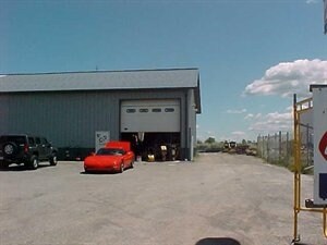

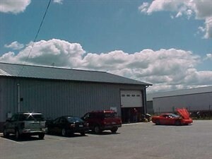
Property Detail
6411 Walmore Rd
Buffalo-Cheektowaga, NY
12/94 11989 18,000
294000-147-000-0001-069-000
NIAGARA
Warehouse
New York
AE The base floodplain where base flood elevations are provided. AE Zones are now used on new format FIRMs instead of A1-A30 Zones.
69.000
2025
1.33 AC
2024
Outlying Niagara County
022715
Buffalo/Niagara Falls
8,601 SF
NEARBY LISTINGS FOR SALE OR LEASE
DEMOGRAPHICS near 6411 Walmore Rd
1 mile
3 mile
5 mile
2025 Total Population
389
21,120
56,464
2030 Population
373
20,892
55,968
Pop Growth 2025-2030
(4.11%)
(1.08%)
(0.88%)
Average Age
46
45
44
2025 Total Households
156
9,369
24,444
HH Growth 2025-2030
(3.85%)
(1.12%)
(0.95%)
Median Household Inc
$73,541
$69,917
$72,271
Avg Household Size
2.30
2.20
2.20
2025 Avg HH Vehicles
2.00
2.00
2.00
Median Home Value
$270,588
$188,590
$191,570
Median Year Built
1969
1968
1960
Nearby Places
Map Layers
Map Styles
 Street
 Aerial
Transit
 Traffic
 Biking
Places
Listings with unknown addresses are not visible on the map
- Restaurants
- Banks
- Shops
- Fitness
- Groceries
PUBLIC TRANSPORTATION
COMMUTER RAIL
Niagara Falls Amtrak Station (Empire Service - Amtrak, Maple Leaf - Amtrak)
Drive
Walk
Distance
Niagara Falls Amtrak Station (Empire Service - Amtrak, Maple Leaf - Amtrak)
15 min
8.0 mi
AIRPORT
Niagara Falls International
Drive
Walk
Distance
Niagara Falls International
4 min
1.9 mi
Buffalo Niagara International
Drive
Walk
Distance
Buffalo Niagara International
33 min
18.4 mi
Freight Ports
Port of Toledo
Drive
Walk
Distance
Port of Toledo
376 min
304.8 mi
Nearby Properties
Address
Land Use
TOTAL SIZE
Lot Size
Zoning
Address
Land Use
TOTAL SIZE
Lot Size
Zoning
181,549 SF
81.90 AC
Address
Land Use
TOTAL SIZE
Lot Size
Zoning
410,860 SF
35.20 AC
05 - COMME
Address
Land Use
TOTAL SIZE
Lot Size
Zoning
160.52 AC
06 - INDUS
Address
Land Use
TOTAL SIZE
Lot Size
Zoning
58,226 SF
16.40 AC
Address
Land Use
TOTAL SIZE
Lot Size
Zoning
36.90 AC
06 - INDUS
Address
Land Use
TOTAL SIZE
Lot Size
Zoning
325.10 AC
06 - INDUS
Address
Land Use
TOTAL SIZE
Lot Size
Zoning
Address
Land Use
TOTAL SIZE
Lot Size
Zoning
211,484 SF
18.30 AC
C3
Address
Land Use
TOTAL SIZE
Lot Size
Zoning
10,647 SF
14 AC
C3
Address
Land Use
TOTAL SIZE
Lot Size
Zoning
82,528 SF
3 AC
Address
Land Use
TOTAL SIZE
Lot Size
Zoning
6,369 SF
12.58 AC
C3
Address
Land Use
TOTAL SIZE
Lot Size
Zoning
1,200 SF
49.80 AC
05 - COMME
Address
Land Use
TOTAL SIZE
Lot Size
Zoning
131,133 SF
14.60 AC
05 - COMME
Address
Land Use
TOTAL SIZE
Lot Size
Zoning
65,623 SF
12.05 AC
Address
Land Use
TOTAL SIZE
Lot Size
Zoning
8.40 AC
Address
Land Use
TOTAL SIZE
Lot Size
Zoning
Address
Land Use
TOTAL SIZE
Lot Size
Zoning
87,039 SF
13.10 AC
Address
Land Use
TOTAL SIZE
Lot Size
Zoning
47,716 SF
2 AC
Address
Land Use
TOTAL SIZE
Lot Size
Zoning
134.90 AC
02
Address
Land Use
TOTAL SIZE
Lot Size
Zoning
30,315 SF
14 AC
Address
Land Use
TOTAL SIZE
Lot Size
Zoning
12,558 SF
3.23 AC
R1-A
Address
Land Use
TOTAL SIZE
Lot Size
Zoning
200.67 AC
06 - INDUS
Address
Land Use
TOTAL SIZE
Lot Size
Zoning
11,776 SF
13.75 AC
03 - MULTI
Address
Land Use
TOTAL SIZE
Lot Size
Zoning
50,000 SF
13.10 AC
Address
Land Use
TOTAL SIZE
Lot Size
Zoning
Address
Land Use
TOTAL SIZE
Lot Size
Zoning
84,329 SF
5 AC
C3
Address
Land Use
TOTAL SIZE
Lot Size
Zoning
99,637 SF
5.50 AC
Address
Land Use
TOTAL SIZE
Lot Size
Zoning
20,400 SF
1.82 AC
B2
Address
Land Use
TOTAL SIZE
Lot Size
Zoning
54,582 SF
6.20 AC
C3
Address
Land Use
TOTAL SIZE
Lot Size
Zoning
47,835 SF
8.30 AC
The World's #1 Commercial Real Estate Marketplace
Connect with us
© 2026 CoStar Group
The information above has been obtained from sources believed reliable. While we do not doubt its accuracy we have not verified it and make no guarantee, warranty or representation about it. It is your responsibility to independently confirm its accuracy and completeness. Any projections, opinions, assumptions, or estimates used are for example only and do not represent the current or future performance of the property. The value of this transaction to you depends on tax and other factors which should be evaluated by your tax, financial, and legal advisors. You and your advisors should conduct a careful, independent investigation of the property to determine to your satisfaction the suitability of the property for your needs.