Property Record
6412 Northglenn Dr, Johnston, IA 50131
NEARBY LISTINGS FOR SALE OR LEASE
Property Detail
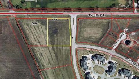
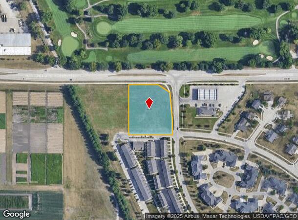
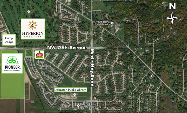
6412 Northglenn Dr
Des Moines-West Des Moines, IA
Johnston Commons Plat 3
241-00747100113
-EX N 6F & COM 6F S OF NW COR TO BEG THN S 8F E 177.25F SE 86.96F N 48.94F NWLY 9.67F ALNG CRV W 245.48F TO POB- LOT 10 JOHNSTON COMMONS PLAT 3
Miscellaneous
Polk
X
Iowa
19153C0179F
10
2024
1.73 AC
2025
Western Suburbs
011406
Des Moines
3,570 SF
DEMOGRAPHICS near 6412 Northglenn Dr
1 Mile
3 Mile
5 Mile
2024 Total Population
4,548
26,459
111,105
2029 Population
4,819
27,450
115,608
Pop Growth 2024-2029
+ 5.96%
+ 3.75%
+ 4.05%
Average Age
35
39
38
2024 Total Households
1,802
10,093
43,364
HH Growth 2024-2029
+ 6.27%
+ 4.02%
+ 4.21%
Median Household Inc
$87,748
$103,026
$90,662
Avg Household Size
2.50
2.60
2.50
2024 Avg HH Vehicles
2.00
2.00
2.00
Median Home Value
$332,305
$300,164
$264,613
Median Year Built
2004
1999
1993
Nearby Places
Map Layers
Map Styles
 Street
 Aerial
- Restaurants
- Banks
- Shops
- Fitness
- Groceries
PUBLIC TRANSPORTATION
AIRPORT
Des Moines International
DRIVE
WALK
Distance
Des Moines International
27 min
13.2 mi
Freight Ports
Port Milwaukee
DRIVE
WALK
Distance
Port Milwaukee
420 min
376.9 mi
SALE & LEASE HISTORY
LISTING DATE
SALE/LEASE

Sep 24, 2016
For Sale
Mar 27, 2017
For Sale
Nearby Properties
Address
Land Use
TOTAL SIZE
Lot Size
Zoning
Address
Land Use
TOTAL SIZE
Lot Size
Zoning
486,792 SF
38.70 AC
PC
Address
Land Use
TOTAL SIZE
Lot Size
Zoning
627,104 SF
40.09 AC
Address
Land Use
TOTAL SIZE
Lot Size
Zoning
197,658 SF
15.91 AC
Address
Land Use
TOTAL SIZE
Lot Size
Zoning
184,658 SF
14.61 AC
Address
Land Use
TOTAL SIZE
Lot Size
Zoning
166,160 SF
11.88 AC
Address
Land Use
TOTAL SIZE
Lot Size
Zoning
287,228 SF
27.32 AC
A-R
Address
Land Use
TOTAL SIZE
Lot Size
Zoning
71,938 SF
8.23 AC
C-O
Address
Land Use
TOTAL SIZE
Lot Size
Zoning
101,592 SF
7.79 AC
PUD
Address
Land Use
TOTAL SIZE
Lot Size
Zoning
141,377 SF
3.16 AC
Address
Land Use
TOTAL SIZE
Lot Size
Zoning
363,736 SF
25.79 AC
M-1
Address
Land Use
TOTAL SIZE
Lot Size
Zoning
146,025 SF
9.59 AC
PUD
Address
Land Use
TOTAL SIZE
Lot Size
Zoning
143,831 SF
16.12 AC
PUD
Address
Land Use
TOTAL SIZE
Lot Size
Zoning
95,039 SF
4.52 AC
PUD
Address
Land Use
TOTAL SIZE
Lot Size
Zoning
115,000 SF
3.69 AC
Address
Land Use
TOTAL SIZE
Lot Size
Zoning
56,478 SF
5.86 AC
Address
Land Use
TOTAL SIZE
Lot Size
Zoning
130,686 SF
1.23 AC
Address
Land Use
TOTAL SIZE
Lot Size
Zoning
59,590 SF
6.05 AC
Address
Land Use
TOTAL SIZE
Lot Size
Zoning
140,163 SF
5.87 AC
PUD
Address
Land Use
TOTAL SIZE
Lot Size
Zoning
50,564 SF
13.14 AC
R-1 (60)
Address
Land Use
TOTAL SIZE
Lot Size
Zoning
95,400 SF
4.40 AC
PUD
Address
Land Use
TOTAL SIZE
Lot Size
Zoning
53,827 SF
5.72 AC
Address
Land Use
TOTAL SIZE
Lot Size
Zoning
80,559 SF
4.50 AC
Address
Land Use
TOTAL SIZE
Lot Size
Zoning
84,941 SF
2.66 AC
Address
Land Use
TOTAL SIZE
Lot Size
Zoning
65,765 SF
3.20 AC
Address
Land Use
TOTAL SIZE
Lot Size
Zoning
39,312 SF
13.08 AC
Address
Land Use
TOTAL SIZE
Lot Size
Zoning
71,984 SF
7.67 AC
Address
Land Use
TOTAL SIZE
Lot Size
Zoning
20,580 SF
5.37 AC
PUD
Address
Land Use
TOTAL SIZE
Lot Size
Zoning
137,340 SF
9.85 AC
CH
Address
Land Use
TOTAL SIZE
Lot Size
Zoning
260,258 SF
21.50 AC
The World's #1 Commercial Real Estate Marketplace
Connect with us
© 2025 CoStar Group
The information above has been obtained from sources believed reliable. While we do not doubt its accuracy we have not verified it and make no guarantee, warranty or representation about it. It is your responsibility to independently confirm its accuracy and completeness. Any projections, opinions, assumptions, or estimates used are for example only and do not represent the current or future performance of the property. The value of this transaction to you depends on tax and other factors which should be evaluated by your tax, financial, and legal advisors. You and your advisors should conduct a careful, independent investigation of the property to determine to your satisfaction the suitability of the property for your needs.