Property Record
6413 Tupelo Dr, Citrus Heights, CA 95621
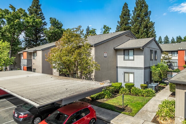

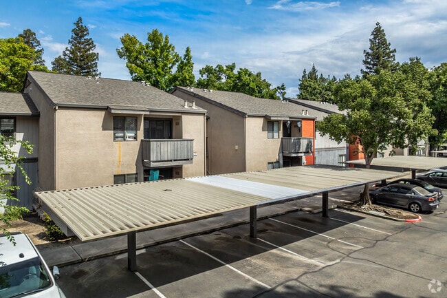
Property Detail
6413 Tupelo Dr
209-0240-020
AKA PAL A OF PM 21-39 POR SW 1/4 SEC 22 T 10 N R6 E MDB&M DESC AS BEG AT A PT LOC S 00%00'28W555.30 FT FROM NE COR SOUTH GRAND OAKS UNIT NO 1TH FM SD POB N 89%24'50E 370.71 FT TH S 99.97FT TH N 89%24'50E 350 FT TO W LINE OF TUPELO DRTH ALG
Apartment
Sacramento
RD20
California
B and X Area of moderate flood hazard, usually the area between the limits of the 100-year and 500-year floods.
36
2024
5.33 AC
2025
Outer Carmichael/Citrus Heights
008129
Sacramento
98,508 SF
Sacramento-Roseville-Folsom, CA
NEARBY LISTINGS FOR SALE OR LEASE
-
-
No Photo
-
View all Citrus Heights listings for sale on LoopNet.com
DEMOGRAPHICS near 6413 Tupelo Dr
1 mile
3 mile
5 mile
2025 Total Population
17,117
157,596
381,116
2030 Population
17,227
159,552
387,983
Pop Growth 2025-2030
+ 0.64%
+ 1.24%
+ 1.80%
Average Age
41
40
40
2025 Total Households
6,262
57,636
140,285
HH Growth 2025-2030
+ 0.65%
+ 1.22%
+ 1.82%
Median Household Inc
$86,432
$83,506
$87,262
Avg Household Size
2.70
2.70
2.60
2025 Avg HH Vehicles
2.00
2.00
2.00
Median Home Value
$428,552
$454,592
$493,821
Median Year Built
1975
1978
1979
Nearby Places
Map Layers
Map Styles
 Street
 Aerial
Layers
 Traffic
 Biking
Places
Listings with unknown addresses are not visible on the map
- Restaurants
- Banks
- Shops
- Fitness
- Groceries
PUBLIC TRANSPORTATION
COMMUTER RAIL
Roseville Amtrak (California Zephyr - Amtrak, Capitol Corridor - Amtrak)
Drive
Walk
Distance
Roseville Amtrak (California Zephyr - Amtrak, Capitol Corridor - Amtrak)
10 min
4.5 mi
Rocklin Amtrak Station (Capitol Corridor - Amtrak)
Drive
Walk
Distance
Rocklin Amtrak Station (Capitol Corridor - Amtrak)
12 min
8.0 mi
AIRPORT
Sacramento International
Drive
Walk
Distance
Sacramento International
29 min
21.5 mi
Freight Ports
Port of Stockton
Drive
Walk
Distance
Port of Stockton
71 min
61.6 mi
SALE & LEASE HISTORY
LISTING DATE
SALE/LEASE

Oct 20, 2020
For Sale
Nearby Properties
Address
Land Use
TOTAL SIZE
Lot Size
Zoning
Address
Land Use
TOTAL SIZE
Lot Size
Zoning
210,380 SF
14.26 AC
Address
Land Use
TOTAL SIZE
Lot Size
Zoning
187,369 SF
15.24 AC
RD20
Address
Land Use
TOTAL SIZE
Lot Size
Zoning
180,595 SF
10.74 AC
RD-30
Address
Land Use
TOTAL SIZE
Lot Size
Zoning
212,037 SF
17.20 AC
BP
Address
Land Use
TOTAL SIZE
Lot Size
Zoning
263,682 SF
14.40 AC
Address
Land Use
TOTAL SIZE
Lot Size
Zoning
183,000 SF
12.49 AC
RD-20
Address
Land Use
TOTAL SIZE
Lot Size
Zoning
14.88 AC
RD-20
Address
Land Use
TOTAL SIZE
Lot Size
Zoning
78,730 SF
8.03 AC
RD20 BP
Address
Land Use
TOTAL SIZE
Lot Size
Zoning
128,480 SF
7.95 AC
RD30 BP
Address
Land Use
TOTAL SIZE
Lot Size
Zoning
58.14 AC
RD-2
Address
Land Use
TOTAL SIZE
Lot Size
Zoning
4.40 AC
RD20
Address
Land Use
TOTAL SIZE
Lot Size
Zoning
99,408 SF
3.53 AC
BP
Address
Land Use
TOTAL SIZE
Lot Size
Zoning
217,550 SF
21.31 AC
SPA
Address
Land Use
TOTAL SIZE
Lot Size
Zoning
4.90 AC
RD30
Address
Land Use
TOTAL SIZE
Lot Size
Zoning
2,080 SF
136.17 AC
FDR
Address
Land Use
TOTAL SIZE
Lot Size
Zoning
200,104 SF
13.85 AC
RD-20
Address
Land Use
TOTAL SIZE
Lot Size
Zoning
4.02 AC
RD20
Address
Land Use
TOTAL SIZE
Lot Size
Zoning
166,268 SF
9.50 AC
RD30
Address
Land Use
TOTAL SIZE
Lot Size
Zoning
148,663 SF
13.19 AC
SPA
Address
Land Use
TOTAL SIZE
Lot Size
Zoning
146,283 SF
8.73 AC
RD-20
Address
Land Use
TOTAL SIZE
Lot Size
Zoning
244,048 SF
13.38 AC
RD-30
Address
Land Use
TOTAL SIZE
Lot Size
Zoning
111,185 SF
8.10 AC
Address
Land Use
TOTAL SIZE
Lot Size
Zoning
160,497 SF
6.85 AC
RD-30
Address
Land Use
TOTAL SIZE
Lot Size
Zoning
0.16 AC
RD-5
Address
Land Use
TOTAL SIZE
Lot Size
Zoning
280,864 SF
14.94 AC
RD-20
Address
Land Use
TOTAL SIZE
Lot Size
Zoning
268,502 SF
12.38 AC
RD30
Address
Land Use
TOTAL SIZE
Lot Size
Zoning
220,691 SF
18.28 AC
RD20
Address
Land Use
TOTAL SIZE
Lot Size
Zoning
141,279 SF
11.56 AC
SPA
Address
Land Use
TOTAL SIZE
Lot Size
Zoning
288,524 SF
11.64 AC
M-1
The World's #1 Commercial Real Estate Marketplace
Connect with us
© 2026 CoStar Group
The information above has been obtained from sources believed reliable. While we do not doubt its accuracy we have not verified it and make no guarantee, warranty or representation about it. It is your responsibility to independently confirm its accuracy and completeness. Any projections, opinions, assumptions, or estimates used are for example only and do not represent the current or future performance of the property. The value of this transaction to you depends on tax and other factors which should be evaluated by your tax, financial, and legal advisors. You and your advisors should conduct a careful, independent investigation of the property to determine to your satisfaction the suitability of the property for your needs.