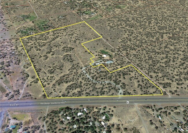
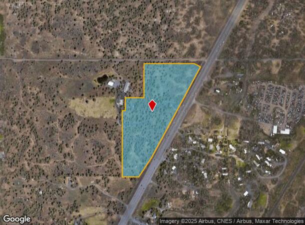
Property Record
64149 N Highway 97, Bend, OR 97701
NEARBY LISTINGS FOR SALE OR LEASE
Property Detail
64149 N Highway 97
Bend-Redmond, OR
Pp2017-02
275037
Deschutes
Sfr
Oregon
X
13.90 AC
41017C0470E
Deschutes County
1,809 SF
Portland
DEMOGRAPHICS near 64149 N Highway 97
1 Mile
3 Mile
5 Mile
2024 Total Population
813
14,941
51,329
2029 Population
902
16,541
57,045
Pop Growth 2024-2029
+ 10.95%
+ 10.71%
+ 11.14%
Average Age
45
41
41
2024 Total Households
303
5,521
20,882
HH Growth 2024-2029
+ 10.89%
+ 10.81%
+ 11.25%
Median Household Inc
$113,928
$104,000
$87,529
Avg Household Size
2.50
2.60
2.40
2024 Avg HH Vehicles
3.00
3.00
2.00
Median Home Value
$709,677
$647,548
$629,117
Median Year Built
1993
2001
1997
Nearby Places
Map Layers
Map Styles
 Street
 Aerial
- Restaurants
- Banks
- Shops
- Fitness
- Groceries
PUBLIC TRANSPORTATION
AIRPORT
Roberts Field
DRIVE
WALK
Distance
Roberts Field
15 min
11.4 mi
Freight Ports
Port of Portland
DRIVE
WALK
Distance
Port of Portland
228 min
159.0 mi
SALE & LEASE HISTORY
LISTING DATE
SALE/LEASE

Aug 14, 2020
For Sale
Nearby Properties
Address
Land Use
TOTAL SIZE
Lot Size
Zoning
Address
Land Use
TOTAL SIZE
Lot Size
Zoning
12,000 SF
2.77 AC
IL
Address
Land Use
TOTAL SIZE
Lot Size
Zoning
2.77 AC
IL
Address
Land Use
TOTAL SIZE
Lot Size
Zoning
7.99 AC
IL
Address
Land Use
TOTAL SIZE
Lot Size
Zoning
7.99 AC
IL
Address
Land Use
TOTAL SIZE
Lot Size
Zoning
317,867 SF
32.72 AC
CG
Address
Land Use
TOTAL SIZE
Lot Size
Zoning
1,546 SF
6.41 AC
RH
Address
Land Use
TOTAL SIZE
Lot Size
Zoning
171,588 SF
4.94 AC
PO
Address
Land Use
TOTAL SIZE
Lot Size
Zoning
12.04 AC
IL
Address
Land Use
TOTAL SIZE
Lot Size
Zoning
120,306 SF
12.04 AC
IL
Address
Land Use
TOTAL SIZE
Lot Size
Zoning
134,322 SF
13.62 AC
CG
Address
Land Use
TOTAL SIZE
Lot Size
Zoning
4.59 AC
RM
Address
Land Use
TOTAL SIZE
Lot Size
Zoning
179,148 SF
17.14 AC
Address
Land Use
TOTAL SIZE
Lot Size
Zoning
3.67 AC
IL
Address
Land Use
TOTAL SIZE
Lot Size
Zoning
3.67 AC
IL
Address
Land Use
TOTAL SIZE
Lot Size
Zoning
95,815 SF
8.66 AC
CG
Address
Land Use
TOTAL SIZE
Lot Size
Zoning
106,042 SF
7.74 AC
IL
Address
Land Use
TOTAL SIZE
Lot Size
Zoning
34,411 SF
13.92 AC
MUA10
Address
Land Use
TOTAL SIZE
Lot Size
Zoning
44,429 SF
13.92 AC
MUA10
Address
Land Use
TOTAL SIZE
Lot Size
Zoning
16,108 SF
6 AC
MUA10
Address
Land Use
TOTAL SIZE
Lot Size
Zoning
33,942 SF
3.16 AC
RH
Address
Land Use
TOTAL SIZE
Lot Size
Zoning
104,295 SF
9.27 AC
CG
Address
Land Use
TOTAL SIZE
Lot Size
Zoning
22,837 SF
27.67 AC
TURE
Address
Land Use
TOTAL SIZE
Lot Size
Zoning
51,596 SF
2 AC
CG
Address
Land Use
TOTAL SIZE
Lot Size
Zoning
55,969 SF
6.31 AC
CG
Address
Land Use
TOTAL SIZE
Lot Size
Zoning
3.23 AC
IL
Address
Land Use
TOTAL SIZE
Lot Size
Zoning
53,623 SF
3.23 AC
IL
Address
Land Use
TOTAL SIZE
Lot Size
Zoning
3.23 AC
IL
Address
Land Use
TOTAL SIZE
Lot Size
Zoning
1.43 AC
ME
Address
Land Use
TOTAL SIZE
Lot Size
Zoning
1.43 AC
ME
The World's #1 Commercial Real Estate Marketplace
Connect with us
© 2025 CoStar Group
The information above has been obtained from sources believed reliable. While we do not doubt its accuracy we have not verified it and make no guarantee, warranty or representation about it. It is your responsibility to independently confirm its accuracy and completeness. Any projections, opinions, assumptions, or estimates used are for example only and do not represent the current or future performance of the property. The value of this transaction to you depends on tax and other factors which should be evaluated by your tax, financial, and legal advisors. You and your advisors should conduct a careful, independent investigation of the property to determine to your satisfaction the suitability of the property for your needs.