Property Record
6415 S State St, Chicago, IL 60637


This Property Is For Sale
NEARBY LISTINGS FOR SALE OR LEASE
Property Detail
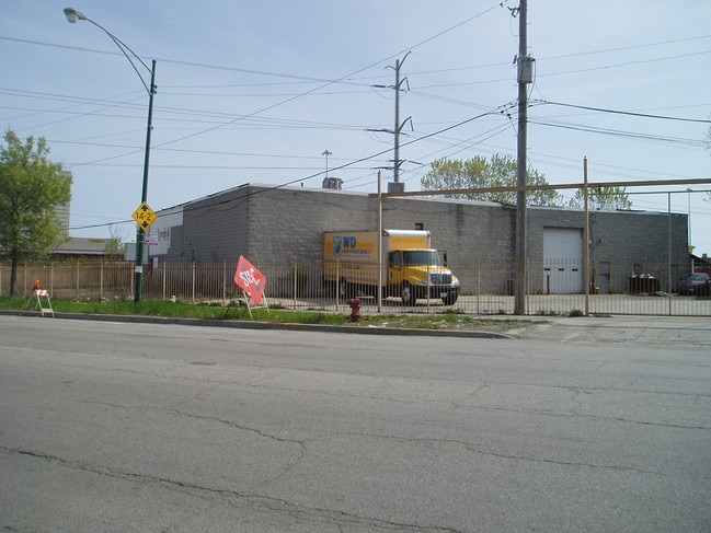
6415 S State St
20-22-100-026-0000
64Th & State Streets
Parkingstructure
Cook
X
Illinois
17031C0538K
3
2023
0.75 AC
2024
South Chicago
842500
Chicago
9,350 SF
Chicago-Naperville-Elgin, IL-IN-WI
DEMOGRAPHICS near 6415 S State St
1 Mile
3 Mile
5 Mile
2024 Total Population
33,427
303,785
675,879
2029 Population
32,618
293,724
645,929
Pop Growth 2024-2029
(2.42%)
(3.31%)
(4.43%)
Average Age
36
38
39
2024 Total Households
13,468
129,121
263,762
HH Growth 2024-2029
(2.71%)
(3.53%)
(4.47%)
Median Household Inc
$22,986
$35,111
$41,893
Avg Household Size
2.40
2.20
2.40
2024 Avg HH Vehicles
1.00
1.00
1.00
Median Home Value
$167,617
$200,961
$201,859
Median Year Built
1951
1949
1949
Nearby Places
Map Layers
Map Styles
 Street
 Aerial
- Restaurants
- Banks
- Shops
- Fitness
- Groceries
PUBLIC TRANSPORTATION
AIRPORT
Chicago Midway International
DRIVE
WALK
Distance
Chicago Midway International
16 min
7.8 mi
Chicago O'Hare International
DRIVE
WALK
Distance
Chicago O'Hare International
39 min
24.9 mi
Nearby Properties
Address
Land Use
TOTAL SIZE
Lot Size
Zoning
Address
Land Use
TOTAL SIZE
Lot Size
Zoning
10.73 AC
PD 1243
Address
Land Use
TOTAL SIZE
Lot Size
Zoning
1,302,463 SF
3.14 AC
PD 1211
Address
Land Use
TOTAL SIZE
Lot Size
Zoning
3.14 AC
PD 1211
Address
Land Use
TOTAL SIZE
Lot Size
Zoning
115,000 SF
1.97 AC
C1-2
Address
Land Use
TOTAL SIZE
Lot Size
Zoning
0.91 AC
PD 1177
Address
Land Use
TOTAL SIZE
Lot Size
Zoning
159,300 SF
13.36 AC
PD 425
Address
Land Use
TOTAL SIZE
Lot Size
Zoning
2.65 AC
PD 38
Address
Land Use
TOTAL SIZE
Lot Size
Zoning
304,685 SF
1.11 AC
PD 1218
Address
Land Use
TOTAL SIZE
Lot Size
Zoning
115,000 SF
1.12 AC
C1-2
Address
Land Use
TOTAL SIZE
Lot Size
Zoning
7,200 SF
0.22 AC
B3-3
Address
Land Use
TOTAL SIZE
Lot Size
Zoning
156,800 SF
2.65 AC
PD 38
Address
Land Use
TOTAL SIZE
Lot Size
Zoning
PD 43
Address
Land Use
TOTAL SIZE
Lot Size
Zoning
451,349 SF
1.62 AC
PD 1062
Address
Land Use
TOTAL SIZE
Lot Size
Zoning
1.65 AC
B2-3
Address
Land Use
TOTAL SIZE
Lot Size
Zoning
PD 43
Address
Land Use
TOTAL SIZE
Lot Size
Zoning
769,600 SF
PD 282
Address
Land Use
TOTAL SIZE
Lot Size
Zoning
78,000 SF
0.62 AC
RM-5
Address
Land Use
TOTAL SIZE
Lot Size
Zoning
7.47 AC
RT-4
Address
Land Use
TOTAL SIZE
Lot Size
Zoning
134,655 SF
2.40 AC
B3-3
Address
Land Use
TOTAL SIZE
Lot Size
Zoning
0.84 AC
RM-5
Address
Land Use
TOTAL SIZE
Lot Size
Zoning
283,228 SF
14.47 AC
PMD 8
Address
Land Use
TOTAL SIZE
Lot Size
Zoning
130,785 SF
2.27 AC
PD 1174
Address
Land Use
TOTAL SIZE
Lot Size
Zoning
156,249 SF
0.57 AC
B3-5
Address
Land Use
TOTAL SIZE
Lot Size
Zoning
293,461 SF
1.19 AC
PD 282
Address
Land Use
TOTAL SIZE
Lot Size
Zoning
13,700 SF
0.33 AC
B3-2
Address
Land Use
TOTAL SIZE
Lot Size
Zoning
117,557 SF
2.69 AC
B3-3
Address
Land Use
TOTAL SIZE
Lot Size
Zoning
258,000 SF
13.22 AC
PMD 8
Address
Land Use
TOTAL SIZE
Lot Size
Zoning
141,165 SF
7.82 AC
PD 966
Address
Land Use
TOTAL SIZE
Lot Size
Zoning
15,052 SF
1.03 AC
PQ
Address
Land Use
TOTAL SIZE
Lot Size
Zoning
214,720 SF
0.92 AC
RM-6.5
The World's #1 Commercial Real Estate Marketplace
Connect with us
© 2025 CoStar Group
The information above has been obtained from sources believed reliable. While we do not doubt its accuracy we have not verified it and make no guarantee, warranty or representation about it. It is your responsibility to independently confirm its accuracy and completeness. Any projections, opinions, assumptions, or estimates used are for example only and do not represent the current or future performance of the property. The value of this transaction to you depends on tax and other factors which should be evaluated by your tax, financial, and legal advisors. You and your advisors should conduct a careful, independent investigation of the property to determine to your satisfaction the suitability of the property for your needs.