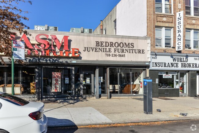
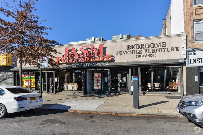
Property Record
6420 20Th Ave, Brooklyn, NY 11204
NEARBY LISTINGS FOR SALE OR LEASE
Property Detail
6420 20Th Ave
05548-0145
Kings
Storebuilding
New York
X
145
3604970351F
0.14 AC
2024
South Brooklyn
2025
Long Island (New York)
025400
New York-Jersey City-White Plains, NY-NJ
10,797 SF
DEMOGRAPHICS near 6420 20Th Ave
1 Mile
3 Mile
5 Mile
2024 Total Population
141,639
1,032,678
1,731,538
2029 Population
130,193
960,215
1,616,441
Pop Growth 2024-2029
(8.08%)
(7.02%)
(6.65%)
Average Age
38
40
40
2024 Total Households
44,378
352,598
627,945
HH Growth 2024-2029
(8.64%)
(7.32%)
(6.92%)
Median Household Inc
$59,288
$64,561
$70,396
Avg Household Size
3.00
2.80
2.60
2024 Avg HH Vehicles
1.00
1.00
1.00
Median Home Value
$955,009
$824,665
$818,515
Median Year Built
1946
1947
1948
Nearby Places
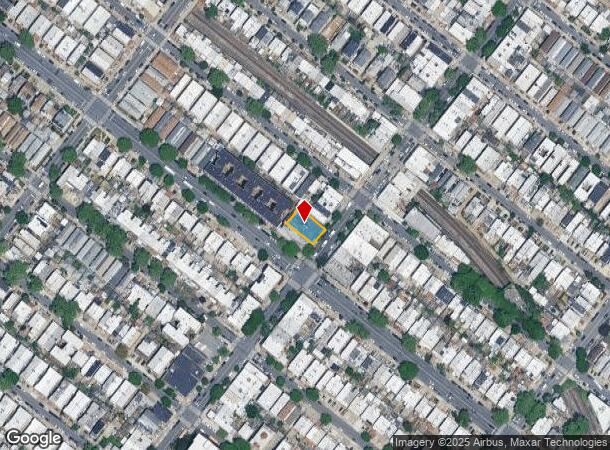
Map Layers
Map Styles
 Street
 Aerial
- Restaurants
- Banks
- Shops
- Fitness
- Groceries
PUBLIC TRANSPORTATION
TRANSIT/SUBWAY
20 Avenue (N Line) (N - New York MTA Subway (The Subway))
DRIVE
WALK
Distance
20 Avenue (N Line) (N - New York MTA Subway (The Subway))
0 min
1 min
0.1 mi
18 Avenue (N Line) (N - New York MTA Subway (The Subway))
DRIVE
WALK
Distance
18 Avenue (N Line) (N - New York MTA Subway (The Subway))
1 min
8 min
0.4 mi
Bay Parkway (N Line) (N - New York MTA Subway (The Subway))
DRIVE
WALK
Distance
Bay Parkway (N Line) (N - New York MTA Subway (The Subway))
2 min
8 min
0.5 mi
Bay Parkway (F Line) (F - New York MTA Subway (The Subway))
DRIVE
WALK
Distance
Bay Parkway (F Line) (F - New York MTA Subway (The Subway))
1 min
15 min
0.8 mi
Avenue N (F - New York MTA Subway (The Subway))
DRIVE
WALK
Distance
Avenue N (F - New York MTA Subway (The Subway))
2 min
17 min
0.9 mi
COMMUTER RAIL
Atlantic Terminal (Babylon Branch - Long Island Rail Road, City Terminal Zone - Long Island Rail Road, Hempstead Branch - Long Island Rail Road, West Hempstead Branch - Long Island Rail Road)
DRIVE
WALK
Distance
Atlantic Terminal (Babylon Branch - Long Island Rail Road, City Terminal Zone - Long Island Rail Road, Hempstead Branch - Long Island Rail Road, West Hempstead Branch - Long Island Rail Road)
13 min
5.8 mi
Clifton (Staten Island Railway - New York MTA Subway (The Subway))
DRIVE
WALK
Distance
Clifton (Staten Island Railway - New York MTA Subway (The Subway))
14 min
7.3 mi
AIRPORT
John F Kennedy International
DRIVE
WALK
Distance
John F Kennedy International
26 min
14.7 mi
LaGuardia
DRIVE
WALK
Distance
LaGuardia
30 min
16.8 mi
Newark Liberty International
DRIVE
WALK
Distance
Newark Liberty International
34 min
20.3 mi
Freight Ports
NY - Red Hook Container Terminal
DRIVE
WALK
Distance
NY - Red Hook Container Terminal
10 min
5.7 mi
SALE & LEASE HISTORY
LISTING DATE
SALE/LEASE

Sep 25, 2016
For Lease
Nearby Properties
Address
Land Use
TOTAL SIZE
Lot Size
Zoning
Address
Land Use
TOTAL SIZE
Lot Size
Zoning
92,440 SF
466.23 AC
R5
Address
Land Use
TOTAL SIZE
Lot Size
Zoning
1,524,659 SF
170.96 AC
R4
Address
Land Use
TOTAL SIZE
Lot Size
Zoning
1,078,317 SF
10.45 AC
R4
Address
Land Use
TOTAL SIZE
Lot Size
Zoning
965,600 SF
6.65 AC
R5
Address
Land Use
TOTAL SIZE
Lot Size
Zoning
460,000 SF
3.21 AC
R6
Address
Land Use
TOTAL SIZE
Lot Size
Zoning
1,073,920 SF
16.53 AC
R6
Address
Land Use
TOTAL SIZE
Lot Size
Zoning
335,800 SF
1.51 AC
R6
Address
Land Use
TOTAL SIZE
Lot Size
Zoning
54.78 AC
PARK
Address
Land Use
TOTAL SIZE
Lot Size
Zoning
785,450 SF
14.22 AC
R6
Address
Land Use
TOTAL SIZE
Lot Size
Zoning
1,324,592 SF
5.13 AC
M3-1
Address
Land Use
TOTAL SIZE
Lot Size
Zoning
397,354 SF
0.61 AC
C5-2
Address
Land Use
TOTAL SIZE
Lot Size
Zoning
393,092 SF
1.07 AC
R8A
Address
Land Use
TOTAL SIZE
Lot Size
Zoning
371,139 SF
3.22 AC
R5
Address
Land Use
TOTAL SIZE
Lot Size
Zoning
5,359,400 SF
59.07 AC
M2-1
Address
Land Use
TOTAL SIZE
Lot Size
Zoning
286,000 SF
12.63 AC
PARK
Address
Land Use
TOTAL SIZE
Lot Size
Zoning
241,735 SF
1.99 AC
C8-4
Address
Land Use
TOTAL SIZE
Lot Size
Zoning
301,400 SF
22.27 AC
M3-1
Address
Land Use
TOTAL SIZE
Lot Size
Zoning
308,757 SF
0.74 AC
R7-1
Address
Land Use
TOTAL SIZE
Lot Size
Zoning
75,340 SF
3.02 AC
PARK
Address
Land Use
TOTAL SIZE
Lot Size
Zoning
139,557 SF
11.47 AC
M1-1
Address
Land Use
TOTAL SIZE
Lot Size
Zoning
623,117 SF
4.16 AC
M3-1
Address
Land Use
TOTAL SIZE
Lot Size
Zoning
171,591 SF
0.14 AC
C5-2
Address
Land Use
TOTAL SIZE
Lot Size
Zoning
846,056 SF
20.71 AC
R5
Address
Land Use
TOTAL SIZE
Lot Size
Zoning
59,063 SF
21.56 AC
PARK
Address
Land Use
TOTAL SIZE
Lot Size
Zoning
209,346 SF
18.29 AC
PARK
Address
Land Use
TOTAL SIZE
Lot Size
Zoning
581,250 SF
3.22 AC
M3-1
Address
Land Use
TOTAL SIZE
Lot Size
Zoning
702,770 SF
4.47 AC
R6
Address
Land Use
TOTAL SIZE
Lot Size
Zoning
247,400 SF
4.34 AC
C44A
Address
Land Use
TOTAL SIZE
Lot Size
Zoning
292,528 SF
1.05 AC
R6
Address
Land Use
TOTAL SIZE
Lot Size
Zoning
61,215 SF
0.32 AC
C64M
The World's #1 Commercial Real Estate Marketplace
Connect with us
© 2025 CoStar Group
The information above has been obtained from sources believed reliable. While we do not doubt its accuracy we have not verified it and make no guarantee, warranty or representation about it. It is your responsibility to independently confirm its accuracy and completeness. Any projections, opinions, assumptions, or estimates used are for example only and do not represent the current or future performance of the property. The value of this transaction to you depends on tax and other factors which should be evaluated by your tax, financial, and legal advisors. You and your advisors should conduct a careful, independent investigation of the property to determine to your satisfaction the suitability of the property for your needs.