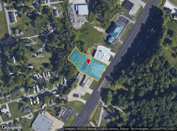
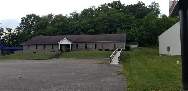
Property Record
6417 Us Route 60, Ashland, KY 41102

NEARBY LISTINGS FOR SALE OR LEASE
Property Detail
6417 Us Route 60
Huntington-Ashland, WV-KY-OH
Yates
024-06-00-025.00
2.93 ACS+- PAR 1 PT 68 LOTS 69THRU 71 PAR II TRACT 4
Religious
Boyd
X
Kentucky
21019C0062D
68,s69
0
2.93 AC
2024
Outlying Boyd County
031003
Huntington/Ashland
6,918 SF
DEMOGRAPHICS near 6417 Us Route 60
1 Mile
3 Mile
5 Mile
2024 Total Population
1,499
16,408
42,282
2029 Population
1,495
16,224
41,790
Pop Growth 2024-2029
(0.27%)
(1.12%)
(1.16%)
Average Age
42
43
42
2024 Total Households
613
6,634
17,423
HH Growth 2024-2029
(0.49%)
(1.13%)
(1.11%)
Median Household Inc
$74,599
$57,301
$54,451
Avg Household Size
2.30
2.40
2.30
2024 Avg HH Vehicles
2.00
2.00
2.00
Median Home Value
$150,000
$138,087
$130,472
Median Year Built
1981
1973
1969
Nearby Places
Map Layers
Map Styles
 Street
 Aerial
- Restaurants
- Banks
- Shops
- Fitness
- Groceries
PUBLIC TRANSPORTATION
COMMUTER RAIL
Ashland Amtrak Station (Cardinal - Amtrak)
DRIVE
WALK
Distance
Ashland Amtrak Station (Cardinal - Amtrak)
8 min
4.8 mi
AIRPORT
Tri-State/Milton J Ferguson Field
DRIVE
WALK
Distance
Tri-State/Milton J Ferguson Field
24 min
14.1 mi
Freight Ports
Port of Toledo
DRIVE
WALK
Distance
Port of Toledo
339 min
261.8 mi
SALE & LEASE HISTORY
LISTING DATE
SALE/LEASE

Sep 26, 2019
For Sale
Nearby Properties
Address
Land Use
TOTAL SIZE
Lot Size
Zoning
Address
Land Use
TOTAL SIZE
Lot Size
Zoning
0.52 AC
Address
Land Use
TOTAL SIZE
Lot Size
Zoning
87.12 AC
COMMERCIAL
Address
Land Use
TOTAL SIZE
Lot Size
Zoning
72.48 AC
COMMERCIAL
Address
Land Use
TOTAL SIZE
Lot Size
Zoning
91,786 SF
2.93 AC
Address
Land Use
TOTAL SIZE
Lot Size
Zoning
11 AC
COMMERCIAL
Address
Land Use
TOTAL SIZE
Lot Size
Zoning
22 AC
OTHER
Address
Land Use
TOTAL SIZE
Lot Size
Zoning
22,592 SF
43.50 AC
OTHER
Address
Land Use
TOTAL SIZE
Lot Size
Zoning
33,980 SF
2.03 AC
COMMERCIAL
Address
Land Use
TOTAL SIZE
Lot Size
Zoning
7.76 AC
Z03
Address
Land Use
TOTAL SIZE
Lot Size
Zoning
36,866 SF
4.70 AC
OTHER
Address
Land Use
TOTAL SIZE
Lot Size
Zoning
9,576 SF
12.29 AC
COMMERCIAL
Address
Land Use
TOTAL SIZE
Lot Size
Zoning
Address
Land Use
TOTAL SIZE
Lot Size
Zoning
22,236 SF
3.96 AC
RESIDENTIA
Address
Land Use
TOTAL SIZE
Lot Size
Zoning
1.04 AC
COMMERCIAL
Address
Land Use
TOTAL SIZE
Lot Size
Zoning
6,840 SF
24 AC
COMMERCIAL
Address
Land Use
TOTAL SIZE
Lot Size
Zoning
1.02 AC
COMMERCIAL
Address
Land Use
TOTAL SIZE
Lot Size
Zoning
9.03 AC
Z02
Address
Land Use
TOTAL SIZE
Lot Size
Zoning
2.44 AC
COMMERCIAL
Address
Land Use
TOTAL SIZE
Lot Size
Zoning
Address
Land Use
TOTAL SIZE
Lot Size
Zoning
1.09 AC
COMMERCIAL
Address
Land Use
TOTAL SIZE
Lot Size
Zoning
6 AC
COMMERCIAL
Address
Land Use
TOTAL SIZE
Lot Size
Zoning
3,520 SF
0.19 AC
COMMERCIAL
Address
Land Use
TOTAL SIZE
Lot Size
Zoning
1.11 AC
COMMERCIAL
Address
Land Use
TOTAL SIZE
Lot Size
Zoning
28,239 SF
2.17 AC
Address
Land Use
TOTAL SIZE
Lot Size
Zoning
19,488 SF
0.28 AC
COMMERCIAL
Address
Land Use
TOTAL SIZE
Lot Size
Zoning
0.60 AC
RESIDENTIA
Address
Land Use
TOTAL SIZE
Lot Size
Zoning
1.29 AC
Address
Land Use
TOTAL SIZE
Lot Size
Zoning
5,580 SF
1.06 AC
Z02
Address
Land Use
TOTAL SIZE
Lot Size
Zoning
6.72 AC
Address
Land Use
TOTAL SIZE
Lot Size
Zoning
1.33 AC
COMMERCIAL
The World's #1 Commercial Real Estate Marketplace
Connect with us
© 2025 CoStar Group
The information above has been obtained from sources believed reliable. While we do not doubt its accuracy we have not verified it and make no guarantee, warranty or representation about it. It is your responsibility to independently confirm its accuracy and completeness. Any projections, opinions, assumptions, or estimates used are for example only and do not represent the current or future performance of the property. The value of this transaction to you depends on tax and other factors which should be evaluated by your tax, financial, and legal advisors. You and your advisors should conduct a careful, independent investigation of the property to determine to your satisfaction the suitability of the property for your needs.