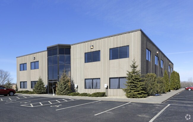
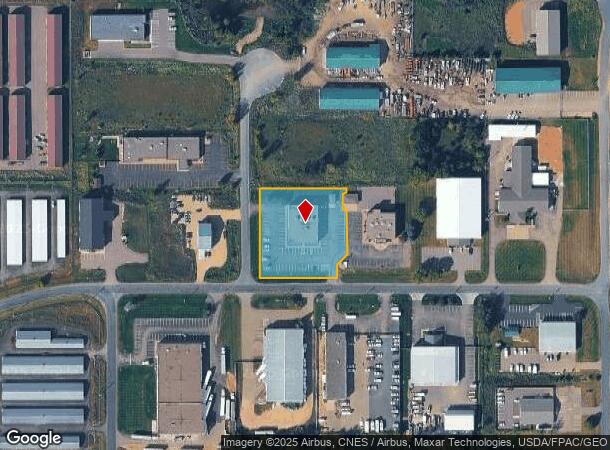
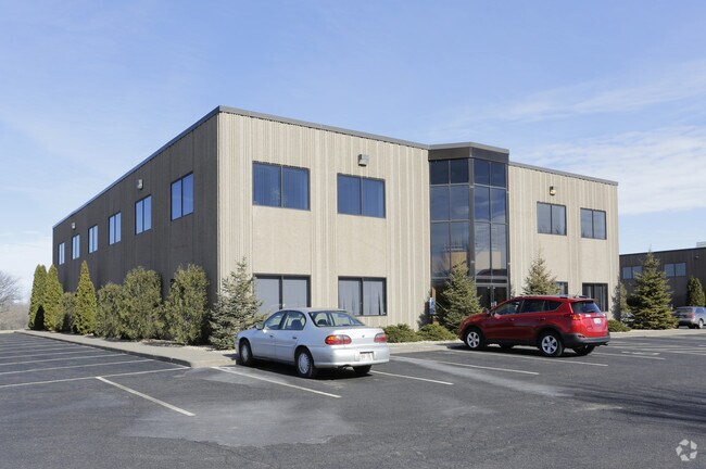
Property Record
642 Brakke Dr, Hudson, WI 54016
NEARBY LISTINGS FOR SALE OR LEASE
Property Detail
642 Brakke Dr
Minneapolis-St. Paul-Bloomington, MN-WI
SEC 27 T29N R19W PT NE SW FKA LOT 2 OF CSM 10/2729 (2.5 ACRES) BEING CSM 22-5418 LOT 4 (1.355 AC)
020-1075-10-775
St Croix
Commercialnec
Wisconsin
X
2,4
55093C0025E
1.36 AC
2025
St Croix County
2024
Minneapolis/St Paul
120202
DEMOGRAPHICS near 642 Brakke Dr
1 Mile
3 Mile
5 Mile
2024 Total Population
1,119
16,001
34,794
2029 Population
1,206
17,246
37,531
Pop Growth 2024-2029
+ 7.77%
+ 7.78%
+ 7.87%
Average Age
41
42
41
2024 Total Households
376
6,040
13,531
HH Growth 2024-2029
+ 7.98%
+ 7.83%
+ 7.89%
Median Household Inc
$148,528
$125,888
$115,359
Avg Household Size
2.90
2.60
2.50
2024 Avg HH Vehicles
3.00
2.00
2.00
Median Home Value
$396,969
$359,471
$365,739
Median Year Built
1992
2001
1995
Nearby Places
Map Layers
Map Styles
 Street
 Aerial
- Restaurants
- Banks
- Shops
- Fitness
- Groceries
PUBLIC TRANSPORTATION
AIRPORT
Minneapolis-St Paul International/Wold-Chamberlain
DRIVE
WALK
Distance
Minneapolis-St Paul International/Wold-Chamberlain
42 min
30.7 mi
SALE & LEASE HISTORY
LISTING DATE
SALE/LEASE

Nov 12, 2024
For Lease
Jun 07, 2018
For Lease
Jan 28, 2021
For Lease
Feb 16, 2017
For Sale
Nearby Properties
Address
Land Use
TOTAL SIZE
Lot Size
Zoning
Address
Land Use
TOTAL SIZE
Lot Size
Zoning
10.90 AC
Address
Land Use
TOTAL SIZE
Lot Size
Zoning
16.42 AC
Address
Land Use
TOTAL SIZE
Lot Size
Zoning
404,968 SF
29.93 AC
I-1
Address
Land Use
TOTAL SIZE
Lot Size
Zoning
3.78 AC
Address
Land Use
TOTAL SIZE
Lot Size
Zoning
255,000 SF
16.74 AC
I-1
Address
Land Use
TOTAL SIZE
Lot Size
Zoning
7.66 AC
Address
Land Use
TOTAL SIZE
Lot Size
Zoning
124,739 SF
10.26 AC
B-2
Address
Land Use
TOTAL SIZE
Lot Size
Zoning
12,271 SF
8.56 AC
B-2
Address
Land Use
TOTAL SIZE
Lot Size
Zoning
100,892 SF
11.32 AC
I-1
Address
Land Use
TOTAL SIZE
Lot Size
Zoning
66,516 SF
5 AC
PRD-2
Address
Land Use
TOTAL SIZE
Lot Size
Zoning
3.68 AC
Address
Land Use
TOTAL SIZE
Lot Size
Zoning
0.90 AC
Address
Land Use
TOTAL SIZE
Lot Size
Zoning
20,845 SF
4.01 AC
B-2
Address
Land Use
TOTAL SIZE
Lot Size
Zoning
20,456 SF
13.93 AC
B-2
Address
Land Use
TOTAL SIZE
Lot Size
Zoning
43,342 SF
8.11 AC
B-2
Address
Land Use
TOTAL SIZE
Lot Size
Zoning
92,971 SF
9.56 AC
B-2
Address
Land Use
TOTAL SIZE
Lot Size
Zoning
28,805 SF
1.67 AC
B-2
Address
Land Use
TOTAL SIZE
Lot Size
Zoning
86,279 SF
8.46 AC
B-2
Address
Land Use
TOTAL SIZE
Lot Size
Zoning
41,976 SF
2.43 AC
B-2
Address
Land Use
TOTAL SIZE
Lot Size
Zoning
580 SF
1.72 AC
B-2
Address
Land Use
TOTAL SIZE
Lot Size
Zoning
55,072 SF
6.33 AC
B-2
Address
Land Use
TOTAL SIZE
Lot Size
Zoning
Address
Land Use
TOTAL SIZE
Lot Size
Zoning
11,576 SF
3.86 AC
B-2
Address
Land Use
TOTAL SIZE
Lot Size
Zoning
27,601 SF
3.21 AC
B-2
Address
Land Use
TOTAL SIZE
Lot Size
Zoning
23,955 SF
1.69 AC
B-2
Address
Land Use
TOTAL SIZE
Lot Size
Zoning
13,780 SF
1.62 AC
B-2
Address
Land Use
TOTAL SIZE
Lot Size
Zoning
30,250 SF
11.14 AC
I-1
Address
Land Use
TOTAL SIZE
Lot Size
Zoning
4.46 AC
I-1
Address
Land Use
TOTAL SIZE
Lot Size
Zoning
7,072 SF
2.73 AC
B-2
Address
Land Use
TOTAL SIZE
Lot Size
Zoning
1.87 AC
The World's #1 Commercial Real Estate Marketplace
Connect with us
© 2026 CoStar Group
The information above has been obtained from sources believed reliable. While we do not doubt its accuracy we have not verified it and make no guarantee, warranty or representation about it. It is your responsibility to independently confirm its accuracy and completeness. Any projections, opinions, assumptions, or estimates used are for example only and do not represent the current or future performance of the property. The value of this transaction to you depends on tax and other factors which should be evaluated by your tax, financial, and legal advisors. You and your advisors should conduct a careful, independent investigation of the property to determine to your satisfaction the suitability of the property for your needs.