Property Record
642 Carl Bethlehem Rd Sw, Bethlehem, GA 30620

NEARBY LISTINGS FOR SALE OR LEASE
Property Detail
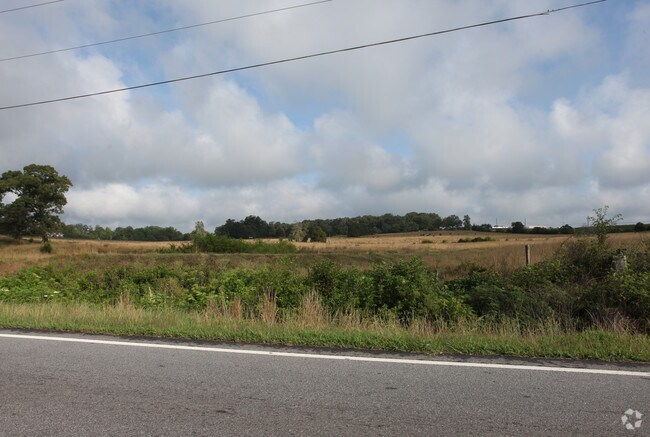
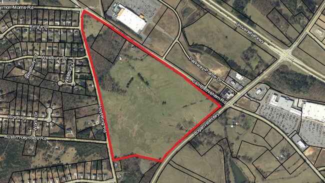
642 Carl Bethlehem Rd Sw
Atlanta-Sandy Springs-Roswell, GA
Meadow Trace
XX053-033
TRACT 2
Residentialacreage
Barrow
X
Georgia
13013C0110D
rur
2024
20.10 AC
2024
Barrow County
180501
Atlanta
1,596 SF
DEMOGRAPHICS near 642 Carl Bethlehem Rd Sw
1 Mile
3 Mile
5 Mile
2024 Total Population
3,786
20,687
48,840
2029 Population
4,444
24,074
56,398
Pop Growth 2024-2029
+ 17.38%
+ 16.37%
+ 15.48%
Average Age
34
35
36
2024 Total Households
1,226
6,737
16,360
HH Growth 2024-2029
+ 17.46%
+ 16.52%
+ 15.74%
Median Household Inc
$69,516
$70,881
$67,350
Avg Household Size
3.00
3.00
2.90
2024 Avg HH Vehicles
2.00
2.00
2.00
Median Home Value
$208,052
$217,224
$219,294
Median Year Built
2004
2002
1998
Nearby Places
Map Layers
Map Styles
 Street
 Aerial
- Restaurants
- Banks
- Shops
- Fitness
- Groceries
SALE & LEASE HISTORY
LISTING DATE
SALE/LEASE

Aug 03, 2017
For Sale
Nearby Properties
Address
Land Use
TOTAL SIZE
Lot Size
Zoning
Address
Land Use
TOTAL SIZE
Lot Size
Zoning
1,456 SF
1,732.80 AC
G
Address
Land Use
TOTAL SIZE
Lot Size
Zoning
10,128 SF
28.20 AC
R-3
Address
Land Use
TOTAL SIZE
Lot Size
Zoning
26,789 SF
35.60 AC
C-3
Address
Land Use
TOTAL SIZE
Lot Size
Zoning
22,320 SF
15.90 AC
R-3
Address
Land Use
TOTAL SIZE
Lot Size
Zoning
305,327 SF
22.10 AC
M-2
Address
Land Use
TOTAL SIZE
Lot Size
Zoning
120,000 SF
142.70 AC
AG
Address
Land Use
TOTAL SIZE
Lot Size
Zoning
2,046 SF
13 AC
B-2,R-3
Address
Land Use
TOTAL SIZE
Lot Size
Zoning
183,060 SF
17.90 AC
M-2
Address
Land Use
TOTAL SIZE
Lot Size
Zoning
167,580 SF
21.80 AC
M-2
Address
Land Use
TOTAL SIZE
Lot Size
Zoning
89,520 SF
14 AC
M-2
Address
Land Use
TOTAL SIZE
Lot Size
Zoning
132,156 SF
10.10 AC
C-2
Address
Land Use
TOTAL SIZE
Lot Size
Zoning
79,029 SF
9.70 AC
C-2
Address
Land Use
TOTAL SIZE
Lot Size
Zoning
37,162 SF
4.60 AC
R-3
Address
Land Use
TOTAL SIZE
Lot Size
Zoning
104,805 SF
12.50 AC
C-3
Address
Land Use
TOTAL SIZE
Lot Size
Zoning
1,188 SF
7.60 AC
R-3
Address
Land Use
TOTAL SIZE
Lot Size
Zoning
60,540 SF
79.30 AC
AG
Address
Land Use
TOTAL SIZE
Lot Size
Zoning
38,550 SF
3 AC
C-2
Address
Land Use
TOTAL SIZE
Lot Size
Zoning
55,420 SF
5 AC
C-3
Address
Land Use
TOTAL SIZE
Lot Size
Zoning
26,802 SF
5 AC
AG
Address
Land Use
TOTAL SIZE
Lot Size
Zoning
24,982 SF
16.10 AC
R-1
Address
Land Use
TOTAL SIZE
Lot Size
Zoning
46,339 SF
2 AC
B-2
Address
Land Use
TOTAL SIZE
Lot Size
Zoning
76,768 SF
19 AC
AG
Address
Land Use
TOTAL SIZE
Lot Size
Zoning
45,296 SF
8.20 AC
B-2
Address
Land Use
TOTAL SIZE
Lot Size
Zoning
19,483 SF
2.80 AC
B-2
Address
Land Use
TOTAL SIZE
Lot Size
Zoning
64,800 SF
47.30 AC
M-1
Address
Land Use
TOTAL SIZE
Lot Size
Zoning
2,398 SF
8.10 AC
R-3
Address
Land Use
TOTAL SIZE
Lot Size
Zoning
49,920 SF
24.50 AC
AG
Address
Land Use
TOTAL SIZE
Lot Size
Zoning
18,240 SF
0.93 AC
B-2
Address
Land Use
TOTAL SIZE
Lot Size
Zoning
5,500 SF
12.90 AC
C-3
Address
Land Use
TOTAL SIZE
Lot Size
Zoning
14,300 SF
5.80 AC
M-1
The World's #1 Commercial Real Estate Marketplace
Connect with us
© 2025 CoStar Group
The information above has been obtained from sources believed reliable. While we do not doubt its accuracy we have not verified it and make no guarantee, warranty or representation about it. It is your responsibility to independently confirm its accuracy and completeness. Any projections, opinions, assumptions, or estimates used are for example only and do not represent the current or future performance of the property. The value of this transaction to you depends on tax and other factors which should be evaluated by your tax, financial, and legal advisors. You and your advisors should conduct a careful, independent investigation of the property to determine to your satisfaction the suitability of the property for your needs.