Property Record
642 Davids Dr, Wilmington, OH 45177
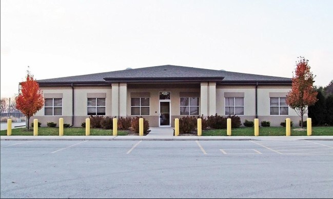

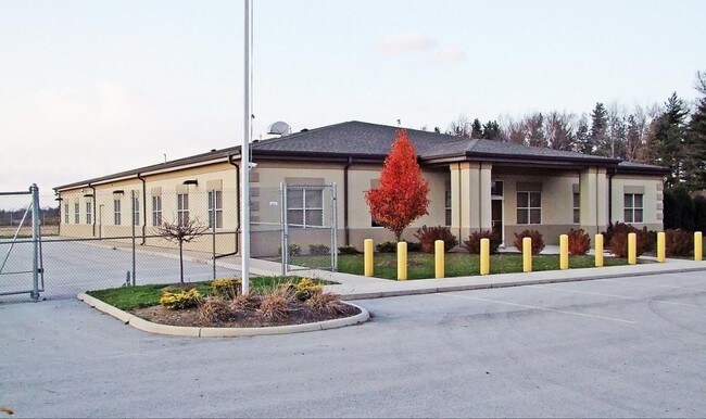
Property Detail
642 Davids Dr
290-21-07-07-0000-00
MS 2693 WILMINGTON ACADEMY SCHOOL PARKING LOT PENDING EXEMPTION 20DUP EXEMPTION GRANTED 7/25/2019
Officebuilding
CLINTON
B and X Area of moderate flood hazard, usually the area between the limits of the 100-year and 500-year floods.
Ohio
2025
2.14 AC
2025
Ohio South Area
964700
Other Market Areas
8,968 SF
Wilmington, OH
NEARBY LISTINGS FOR SALE OR LEASE
-
-
View all Wilmington listings for sale on LoopNet.com
DEMOGRAPHICS near 642 Davids Dr
1 mile
3 mile
5 mile
2025 Total Population
499
13,075
17,133
2030 Population
496
13,088
17,155
Pop Growth 2025-2030
(0.60%)
+ 0.10%
+ 0.13%
Average Age
32
39
40
2025 Total Households
125
5,295
6,896
HH Growth 2025-2030
+ 0.80%
+ 0.23%
+ 0.22%
Median Household Inc
$65,000
$55,409
$60,191
Avg Household Size
2.20
2.20
2.30
2025 Avg HH Vehicles
1.00
2.00
2.00
Median Home Value
$154,255
$176,768
$195,410
Median Year Built
1974
1973
1978
Nearby Places
Map Layers
Map Styles
 Street
 Aerial
Layers
 Traffic
 Biking
Places
Listings with unknown addresses are not visible on the map
- Restaurants
- Banks
- Shops
- Fitness
- Groceries
PUBLIC TRANSPORTATION
AIRPORT
James M Cox Dayton International
Drive
Walk
Distance
James M Cox Dayton International
76 min
49.5 mi
Nearby Properties
Address
Land Use
TOTAL SIZE
Lot Size
Zoning
Address
Land Use
TOTAL SIZE
Lot Size
Zoning
68,375 SF
0.01 AC
Address
Land Use
TOTAL SIZE
Lot Size
Zoning
9,000 SF
1,048.03 AC
Address
Land Use
TOTAL SIZE
Lot Size
Zoning
42,621 SF
26.45 AC
Address
Land Use
TOTAL SIZE
Lot Size
Zoning
69,324 SF
46.77 AC
I2
Address
Land Use
TOTAL SIZE
Lot Size
Zoning
96,727 SF
26.63 AC
Address
Land Use
TOTAL SIZE
Lot Size
Zoning
112,625 SF
4.46 AC
Address
Land Use
TOTAL SIZE
Lot Size
Zoning
12,200 SF
40.56 AC
I2
Address
Land Use
TOTAL SIZE
Lot Size
Zoning
404,416 SF
55.93 AC
Address
Land Use
TOTAL SIZE
Lot Size
Zoning
300,785 SF
19.79 AC
I2
Address
Land Use
TOTAL SIZE
Lot Size
Zoning
78.11 AC
Address
Land Use
TOTAL SIZE
Lot Size
Zoning
Address
Land Use
TOTAL SIZE
Lot Size
Zoning
221,961 SF
8.97 AC
Address
Land Use
TOTAL SIZE
Lot Size
Zoning
417,229 SF
16.74 AC
Address
Land Use
TOTAL SIZE
Lot Size
Zoning
83,588 SF
23.10 AC
I2
Address
Land Use
TOTAL SIZE
Lot Size
Zoning
202,778 SF
24.07 AC
RR
Address
Land Use
TOTAL SIZE
Lot Size
Zoning
12,525 SF
3.41 AC
Address
Land Use
TOTAL SIZE
Lot Size
Zoning
11,840 SF
17.56 AC
SR
Address
Land Use
TOTAL SIZE
Lot Size
Zoning
479.38 AC
Address
Land Use
TOTAL SIZE
Lot Size
Zoning
78,732 SF
20.31 AC
Address
Land Use
TOTAL SIZE
Lot Size
Zoning
18,124 SF
10 AC
Address
Land Use
TOTAL SIZE
Lot Size
Zoning
121,600 SF
7.23 AC
Address
Land Use
TOTAL SIZE
Lot Size
Zoning
121,600 SF
6.13 AC
Address
Land Use
TOTAL SIZE
Lot Size
Zoning
40,955 SF
7.18 AC
Address
Land Use
TOTAL SIZE
Lot Size
Zoning
97,636 SF
19.77 AC
Address
Land Use
TOTAL SIZE
Lot Size
Zoning
102,400 SF
6.45 AC
I2
Address
Land Use
TOTAL SIZE
Lot Size
Zoning
3,740 SF
1.18 AC
Address
Land Use
TOTAL SIZE
Lot Size
Zoning
102,400 SF
6.45 AC
I2
Address
Land Use
TOTAL SIZE
Lot Size
Zoning
102,400 SF
6.25 AC
I2
Address
Land Use
TOTAL SIZE
Lot Size
Zoning
102,400 SF
6.52 AC
I2
Address
Land Use
TOTAL SIZE
Lot Size
Zoning
8,707 SF
5.01 AC
The World's #1 Commercial Real Estate Marketplace
Connect with us
© 2026 CoStar Group
The information above has been obtained from sources believed reliable. While we do not doubt its accuracy we have not verified it and make no guarantee, warranty or representation about it. It is your responsibility to independently confirm its accuracy and completeness. Any projections, opinions, assumptions, or estimates used are for example only and do not represent the current or future performance of the property. The value of this transaction to you depends on tax and other factors which should be evaluated by your tax, financial, and legal advisors. You and your advisors should conduct a careful, independent investigation of the property to determine to your satisfaction the suitability of the property for your needs.