Property Record
642 W 83Rd St, Hialeah, FL 33014
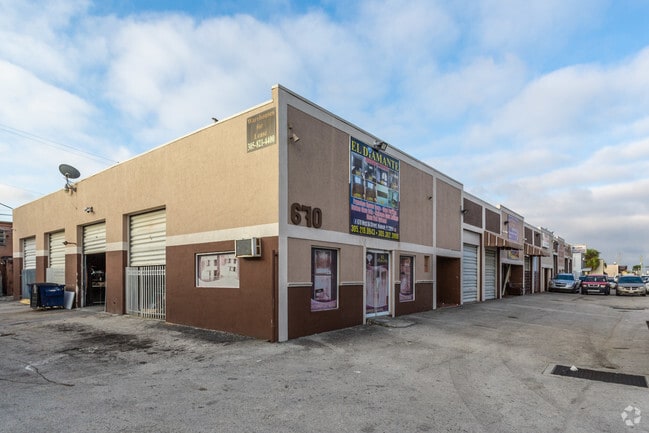


Property Detail
642 W 83Rd St
04-2025-001-0168
25 52 40 1.81 AC SUB OF PB 2-17 W366.45FT OF E731.45FT OF TR 16 LESS N90FT & LESS S25FT THEREOF PER UNITY OF TITLE TO CITY OF HIALEAH DATED 2-5-68 LOT SIZE 78843 SQUARE FEET OR 20906-0292 06 2001 4
Warehouse
MIAMI/DADE
7100
Florida
B and X Area of moderate flood hazard, usually the area between the limits of the 100-year and 500-year floods.
1.81 AC
2024
Miami Lakes
2025
South Florida
009305
Miami-Miami Beach-Kendall, FL
50,961 SF
NEARBY LISTINGS FOR SALE OR LEASE
DEMOGRAPHICS near 642 W 83Rd St
1 mile
3 mile
5 mile
2025 Total Population
20,285
206,922
491,693
2030 Population
21,820
219,806
522,289
Pop Growth 2025-2030
+ 7.57%
+ 6.23%
+ 6.22%
Average Age
43
43
42
2025 Total Households
6,870
69,967
158,837
HH Growth 2025-2030
+ 7.48%
+ 6.20%
+ 6.17%
Median Household Inc
$59,459
$64,584
$65,147
Avg Household Size
2.90
2.90
3.00
2025 Avg HH Vehicles
2.00
2.00
2.00
Median Home Value
$465,908
$407,500
$418,210
Median Year Built
1973
1979
1977
Nearby Places
Map Layers
Map Styles
 Street
 Aerial
Layers
 Traffic
 Biking
Places
Listings with unknown addresses are not visible on the map
- Restaurants
- Banks
- Shops
- Fitness
- Groceries
PUBLIC TRANSPORTATION
COMMUTER RAIL
Opa-Locka (Tri-County Commuter - South Florida Regional Transportation Authority (Tri-Rail))
Drive
Walk
Distance
Opa-Locka (Tri-County Commuter - South Florida Regional Transportation Authority (Tri-Rail))
6 min
3.0 mi
Okeechobee (Metrorail Green Line - Miami-Dade Transit (Metrorail/Metromover))
Drive
Walk
Distance
Okeechobee (Metrorail Green Line - Miami-Dade Transit (Metrorail/Metromover))
11 min
5.3 mi
AIRPORT
Miami International
Drive
Walk
Distance
Miami International
22 min
11.1 mi
Fort Lauderdale/Hollywood International
Drive
Walk
Distance
Fort Lauderdale/Hollywood International
31 min
19.0 mi
Freight Ports
Port of Miami
Drive
Walk
Distance
Port of Miami
28 min
16.1 mi
Nearby Properties
Address
Land Use
TOTAL SIZE
Lot Size
Zoning
Address
Land Use
TOTAL SIZE
Lot Size
Zoning
1,837,228 SF
498.34 AC
8500
Address
Land Use
TOTAL SIZE
Lot Size
Zoning
614,708 SF
22.54 AC
4400
Address
Land Use
TOTAL SIZE
Lot Size
Zoning
510,395 SF
28.32 AC
6500
Address
Land Use
TOTAL SIZE
Lot Size
Zoning
970,804 SF
46.92 AC
7100
Address
Land Use
TOTAL SIZE
Lot Size
Zoning
649,901 SF
124.04 AC
9400
Address
Land Use
TOTAL SIZE
Lot Size
Zoning
696,550 SF
2.97 AC
6109
Address
Land Use
TOTAL SIZE
Lot Size
Zoning
968,497 SF
58.61 AC
7100
Address
Land Use
TOTAL SIZE
Lot Size
Zoning
301,593 SF
16 AC
7100
Address
Land Use
TOTAL SIZE
Lot Size
Zoning
1,165,101 SF
115.84 AC
8000
Address
Land Use
TOTAL SIZE
Lot Size
Zoning
355,120 SF
18 AC
5000
Address
Land Use
TOTAL SIZE
Lot Size
Zoning
603,504 SF
27.15 AC
7100
Address
Land Use
TOTAL SIZE
Lot Size
Zoning
331,131 SF
12.09 AC
3900
Address
Land Use
TOTAL SIZE
Lot Size
Zoning
382,421 SF
19.66 AC
3700
Address
Land Use
TOTAL SIZE
Lot Size
Zoning
207,475 SF
51.47 AC
7100
Address
Land Use
TOTAL SIZE
Lot Size
Zoning
370,044 SF
17.86 AC
6051
Address
Land Use
TOTAL SIZE
Lot Size
Zoning
400,062 SF
33.33 AC
0101
Address
Land Use
TOTAL SIZE
Lot Size
Zoning
315,033 SF
11.48 AC
6109
Address
Land Use
TOTAL SIZE
Lot Size
Zoning
866,013 SF
0.11 AC
8000
Address
Land Use
TOTAL SIZE
Lot Size
Zoning
419,656 SF
8.61 AC
6400
Address
Land Use
TOTAL SIZE
Lot Size
Zoning
445,429 SF
4.45 AC
6400
Address
Land Use
TOTAL SIZE
Lot Size
Zoning
552,632 SF
6.05 AC
4100
Address
Land Use
TOTAL SIZE
Lot Size
Zoning
478,031 SF
1.72 AC
6600
Address
Land Use
TOTAL SIZE
Lot Size
Zoning
389,450 SF
50.72 AC
9400
Address
Land Use
TOTAL SIZE
Lot Size
Zoning
261,263 SF
9.22 AC
6109
Address
Land Use
TOTAL SIZE
Lot Size
Zoning
366,063 SF
57.35 AC
7100
Address
Land Use
TOTAL SIZE
Lot Size
Zoning
286,547 SF
9.47 AC
6109
Address
Land Use
TOTAL SIZE
Lot Size
Zoning
167,427 SF
6.85 AC
3900
Address
Land Use
TOTAL SIZE
Lot Size
Zoning
68,227 SF
388.62 AC
8000
Address
Land Use
TOTAL SIZE
Lot Size
Zoning
335,221 SF
21.51 AC
6400
Address
Land Use
TOTAL SIZE
Lot Size
Zoning
223,723 SF
35.59 AC
0100
The World's #1 Commercial Real Estate Marketplace
Connect with us
© 2026 CoStar Group
The information above has been obtained from sources believed reliable. While we do not doubt its accuracy we have not verified it and make no guarantee, warranty or representation about it. It is your responsibility to independently confirm its accuracy and completeness. Any projections, opinions, assumptions, or estimates used are for example only and do not represent the current or future performance of the property. The value of this transaction to you depends on tax and other factors which should be evaluated by your tax, financial, and legal advisors. You and your advisors should conduct a careful, independent investigation of the property to determine to your satisfaction the suitability of the property for your needs.