Property Record
6420 Fm Rr 2244 Rd, Austin, TX 78746
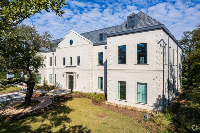

Property Detail
6420 Fm Rr 2244 Rd
Austin-Round Rock-San Marcos, TX
LOT 1 *LESS .07AC BAKER HILLS
117667
TRAVIS
Officebuilding
Texas
B and X Area of moderate flood hazard, usually the area between the limits of the 100-year and 500-year floods.
1
2025
4.49 AC
2025
Southwest
001918
Austin
15,724 SF
NEARBY LISTINGS FOR SALE OR LEASE
DEMOGRAPHICS near 6420 Fm Rr 2244 Rd
1 mile
3 mile
5 mile
2025 Total Population
2,364
25,462
116,756
2030 Population
2,449
26,492
121,820
Pop Growth 2025-2030
+ 3.60%
+ 4.05%
+ 4.34%
Average Age
44
43
41
2025 Total Households
846
9,362
50,930
HH Growth 2025-2030
+ 4.26%
+ 4.84%
+ 5.11%
Median Household Inc
$209,663
$219,927
$143,209
Avg Household Size
2.70
2.70
2.20
2025 Avg HH Vehicles
2.00
2.00
2.00
Median Home Value
$1,092,529
$1,107,693
$1,058,168
Median Year Built
1987
1992
1993
Nearby Places
Map Layers
Map Styles
 Street
 Aerial
Layers
 Traffic
 Biking
Places
Listings with unknown addresses are not visible on the map
- Restaurants
- Banks
- Shops
- Fitness
- Groceries
PUBLIC TRANSPORTATION
COMMUTER RAIL
Austin (Texas Eagle - Amtrak)
Drive
Walk
Distance
Austin (Texas Eagle - Amtrak)
13 min
6.6 mi
AIRPORT
Austin-Bergstrom International
Drive
Walk
Distance
Austin-Bergstrom International
29 min
16.1 mi
Freight Ports
Calhoun Port
Drive
Walk
Distance
Calhoun Port
195 min
159.6 mi
SALE & LEASE HISTORY
LISTING DATE
SALE/LEASE

Jun 07, 2021
For Lease
Nearby Properties
Address
Land Use
TOTAL SIZE
Lot Size
Zoning
Address
Land Use
TOTAL SIZE
Lot Size
Zoning
632.50 AC
Address
Land Use
TOTAL SIZE
Lot Size
Zoning
599,648 SF
16.83 AC
Address
Land Use
TOTAL SIZE
Lot Size
Zoning
377,128 SF
14.99 AC
Address
Land Use
TOTAL SIZE
Lot Size
Zoning
221,273 SF
48.10 AC
Address
Land Use
TOTAL SIZE
Lot Size
Zoning
217,490 SF
19.03 AC
Address
Land Use
TOTAL SIZE
Lot Size
Zoning
344,392 SF
24.53 AC
Address
Land Use
TOTAL SIZE
Lot Size
Zoning
71,812 SF
9.18 AC
Address
Land Use
TOTAL SIZE
Lot Size
Zoning
349,535 SF
245.89 AC
Address
Land Use
TOTAL SIZE
Lot Size
Zoning
210,000 SF
12.74 AC
Address
Land Use
TOTAL SIZE
Lot Size
Zoning
149,610 SF
12.67 AC
Address
Land Use
TOTAL SIZE
Lot Size
Zoning
135,103 SF
20.58 AC
Address
Land Use
TOTAL SIZE
Lot Size
Zoning
170,058 SF
28.28 AC
Address
Land Use
TOTAL SIZE
Lot Size
Zoning
202,346 SF
16.50 AC
Address
Land Use
TOTAL SIZE
Lot Size
Zoning
102.28 AC
Address
Land Use
TOTAL SIZE
Lot Size
Zoning
153,404 SF
13.60 AC
Address
Land Use
TOTAL SIZE
Lot Size
Zoning
130,476 SF
13.60 AC
Address
Land Use
TOTAL SIZE
Lot Size
Zoning
149,352 SF
20.99 AC
Address
Land Use
TOTAL SIZE
Lot Size
Zoning
161,450 SF
19.03 AC
Address
Land Use
TOTAL SIZE
Lot Size
Zoning
83,110 SF
32 AC
Address
Land Use
TOTAL SIZE
Lot Size
Zoning
156,682 SF
3.45 AC
Address
Land Use
TOTAL SIZE
Lot Size
Zoning
110,911 SF
13.37 AC
Address
Land Use
TOTAL SIZE
Lot Size
Zoning
164,188 SF
6.36 AC
Address
Land Use
TOTAL SIZE
Lot Size
Zoning
294,733 SF
14.62 AC
Address
Land Use
TOTAL SIZE
Lot Size
Zoning
142,000 SF
7.82 AC
Address
Land Use
TOTAL SIZE
Lot Size
Zoning
156,682 SF
3.15 AC
Address
Land Use
TOTAL SIZE
Lot Size
Zoning
141,927 SF
21.20 AC
Address
Land Use
TOTAL SIZE
Lot Size
Zoning
35,107 SF
27.33 AC
Address
Land Use
TOTAL SIZE
Lot Size
Zoning
127,184 SF
7.09 AC
Address
Land Use
TOTAL SIZE
Lot Size
Zoning
139,776 SF
8.42 AC
Address
Land Use
TOTAL SIZE
Lot Size
Zoning
116,596 SF
3.39 AC
The World's #1 Commercial Real Estate Marketplace
Connect with us
© 2026 CoStar Group
The information above has been obtained from sources believed reliable. While we do not doubt its accuracy we have not verified it and make no guarantee, warranty or representation about it. It is your responsibility to independently confirm its accuracy and completeness. Any projections, opinions, assumptions, or estimates used are for example only and do not represent the current or future performance of the property. The value of this transaction to you depends on tax and other factors which should be evaluated by your tax, financial, and legal advisors. You and your advisors should conduct a careful, independent investigation of the property to determine to your satisfaction the suitability of the property for your needs.