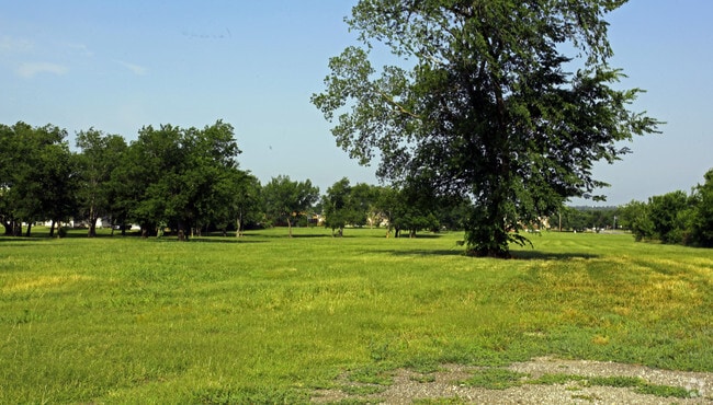
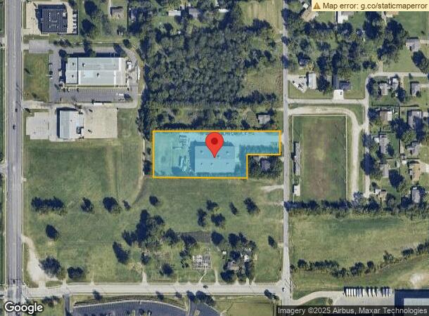
Property Record
6420 S 101St Ave E, Tulsa, OK 74133

NEARBY LISTINGS FOR SALE OR LEASE
Property Detail
6420 S 101St Ave E
Tulsa, OK
Luxe Cheer
76225-84-06-01610
LOT 1 BLOCK 1
Warehouse
Tulsa
X
Oklahoma
40143C0378L
1
2025
2.36 AC
2025
South Central
007527
Tulsa
21,580 SF
DEMOGRAPHICS near 6420 S 101St Ave E
1 Mile
3 Mile
5 Mile
2024 Total Population
11,563
82,563
242,091
2029 Population
11,950
84,783
249,411
Pop Growth 2024-2029
+ 3.35%
+ 2.69%
+ 3.02%
Average Age
37
39
39
2024 Total Households
5,211
34,699
98,239
HH Growth 2024-2029
+ 3.45%
+ 2.77%
+ 3.10%
Median Household Inc
$47,627
$59,380
$63,693
Avg Household Size
2.10
2.30
2.40
2024 Avg HH Vehicles
1.00
2.00
2.00
Median Home Value
$154,743
$193,920
$198,005
Median Year Built
1984
1984
1980
Nearby Places
Map Layers
Map Styles
 Street
 Aerial
- Restaurants
- Banks
- Shops
- Fitness
- Groceries
PUBLIC TRANSPORTATION
AIRPORT
Tulsa International
DRIVE
WALK
Distance
Tulsa International
21 min
13.4 mi
Freight Ports
Tulsa Port Of Catoosa
DRIVE
WALK
Distance
Tulsa Port Of Catoosa
24 min
17.2 mi
Nearby Properties
Address
Land Use
TOTAL SIZE
Lot Size
Zoning
Address
Land Use
TOTAL SIZE
Lot Size
Zoning
717,386 SF
49.74 AC
OL
Address
Land Use
TOTAL SIZE
Lot Size
Zoning
323,882 SF
20 AC
CO
Address
Land Use
TOTAL SIZE
Lot Size
Zoning
157,138 SF
9.28 AC
CO
Address
Land Use
TOTAL SIZE
Lot Size
Zoning
80,431 SF
9.51 AC
IL
Address
Land Use
TOTAL SIZE
Lot Size
Zoning
184,679 SF
33.97 AC
AG
Address
Land Use
TOTAL SIZE
Lot Size
Zoning
236,738 SF
11.56 AC
PUD
Address
Land Use
TOTAL SIZE
Lot Size
Zoning
304,789 SF
40.82 AC
CO
Address
Land Use
TOTAL SIZE
Lot Size
Zoning
139,648 SF
20.75 AC
RS3
Address
Land Use
TOTAL SIZE
Lot Size
Zoning
78,119 SF
11.11 AC
CO
Address
Land Use
TOTAL SIZE
Lot Size
Zoning
163,472 SF
29.92 AC
AG
Address
Land Use
TOTAL SIZE
Lot Size
Zoning
25,173 SF
155.93 AC
RS3
Address
Land Use
TOTAL SIZE
Lot Size
Zoning
72,042 SF
5.10 AC
RS3
Address
Land Use
TOTAL SIZE
Lot Size
Zoning
592,682 SF
30.42 AC
CO
Address
Land Use
TOTAL SIZE
Lot Size
Zoning
55,283 SF
39.50 AC
SR
Address
Land Use
TOTAL SIZE
Lot Size
Zoning
56,611 SF
26.92 AC
RS2
Address
Land Use
TOTAL SIZE
Lot Size
Zoning
625 SF
78.96 AC
RS3
Address
Land Use
TOTAL SIZE
Lot Size
Zoning
117,537 SF
14.99 AC
CO
Address
Land Use
TOTAL SIZE
Lot Size
Zoning
86,747 SF
19.01 AC
RS3
Address
Land Use
TOTAL SIZE
Lot Size
Zoning
57,630 SF
35.09 AC
IL
Address
Land Use
TOTAL SIZE
Lot Size
Zoning
33,332 SF
2.92 AC
CO
Address
Land Use
TOTAL SIZE
Lot Size
Zoning
260,059 SF
19.99 AC
CO
Address
Land Use
TOTAL SIZE
Lot Size
Zoning
71,362 SF
14.08 AC
RD
Address
Land Use
TOTAL SIZE
Lot Size
Zoning
22,594 SF
2.07 AC
ON
Address
Land Use
TOTAL SIZE
Lot Size
Zoning
279,517 SF
25.43 AC
CO
Address
Land Use
TOTAL SIZE
Lot Size
Zoning
59,175 SF
8.28 AC
RS3
Address
Land Use
TOTAL SIZE
Lot Size
Zoning
41,057 SF
5.45 AC
IL
Address
Land Use
TOTAL SIZE
Lot Size
Zoning
20,292 SF
48.11 AC
CO
Address
Land Use
TOTAL SIZE
Lot Size
Zoning
118,204 SF
4.59 AC
RS3
Address
Land Use
TOTAL SIZE
Lot Size
Zoning
60,790 SF
10.84 AC
R1
Address
Land Use
TOTAL SIZE
Lot Size
Zoning
248,577 SF
12.01 AC
CG
The World's #1 Commercial Real Estate Marketplace
Connect with us
© 2025 CoStar Group
The information above has been obtained from sources believed reliable. While we do not doubt its accuracy we have not verified it and make no guarantee, warranty or representation about it. It is your responsibility to independently confirm its accuracy and completeness. Any projections, opinions, assumptions, or estimates used are for example only and do not represent the current or future performance of the property. The value of this transaction to you depends on tax and other factors which should be evaluated by your tax, financial, and legal advisors. You and your advisors should conduct a careful, independent investigation of the property to determine to your satisfaction the suitability of the property for your needs.