Property Record
6421 E Huntsman Ave, Selma, CA 93662

Property Detail
6421 E Huntsman Ave
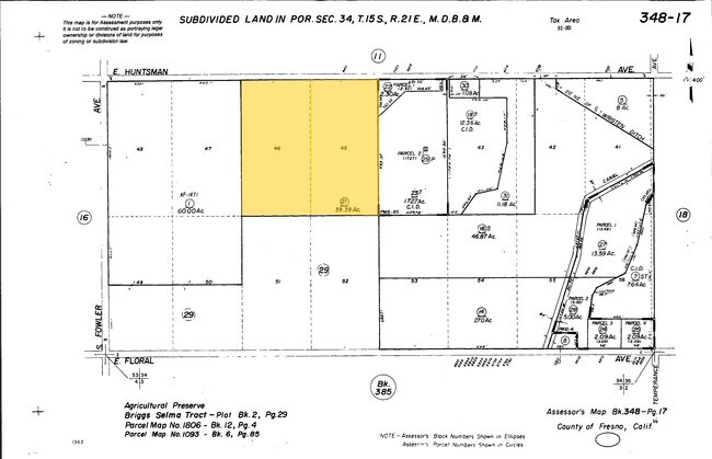
348-170-21
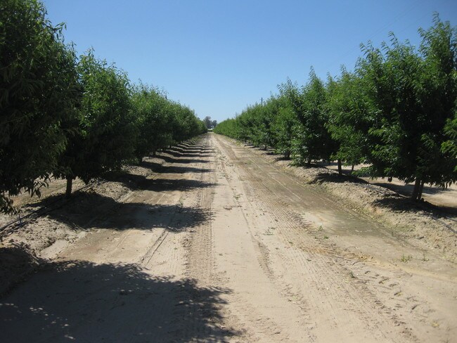
39.39 AC IN LOTS 45 & 46 BRIGGS SELMA TR
Orchard
FRESNO
AE20
California
B and X Area of moderate flood hazard, usually the area between the limits of the 100-year and 500-year floods.
46
2025
39.39 AC
2025
W Outlying Fresno County
007300
Fresno
972 SF
Fresno, CA
NEARBY LISTINGS FOR SALE OR LEASE
-
-
View all Selma listings for sale on LoopNet.com
DEMOGRAPHICS near 6421 E Huntsman Ave
1 mile
3 mile
5 mile
2025 Total Population
371
7,973
38,993
2030 Population
355
8,045
39,426
Pop Growth 2025-2030
(4.31%)
+ 0.90%
+ 1.11%
Average Age
39
36
36
2025 Total Households
114
2,171
11,272
HH Growth 2025-2030
(4.39%)
+ 0.83%
+ 1.06%
Median Household Inc
$72,499
$64,571
$58,137
Avg Household Size
3.20
3.60
3.40
2025 Avg HH Vehicles
3.00
2.00
2.00
Median Home Value
$713,235
$366,666
$359,850
Median Year Built
1963
1986
1979
Nearby Places
Map Layers
Map Styles
 Street
 Aerial
Layers
 Traffic
 Biking
Places
Listings with unknown addresses are not visible on the map
- Restaurants
- Banks
- Shops
- Fitness
- Groceries
PUBLIC TRANSPORTATION
AIRPORT
Fresno Yosemite International
Drive
Walk
Distance
Fresno Yosemite International
26 min
15.1 mi
Freight Ports
Port of Stockton
Drive
Walk
Distance
Port of Stockton
167 min
140.2 mi
SALE & LEASE HISTORY
LISTING DATE
SALE/LEASE

Mar 26, 2018
For Sale
Feb 05, 2020
For Sale
Nearby Properties
Address
Land Use
TOTAL SIZE
Lot Size
Zoning
Address
Land Use
TOTAL SIZE
Lot Size
Zoning
725,468 SF
25 AC
MI
Address
Land Use
TOTAL SIZE
Lot Size
Zoning
242,970 SF
30.43 AC
Address
Land Use
TOTAL SIZE
Lot Size
Zoning
270,292 SF
23.86 AC
M1
Address
Land Use
TOTAL SIZE
Lot Size
Zoning
272,338 SF
25.80 AC
M2
Address
Land Use
TOTAL SIZE
Lot Size
Zoning
104,516 SF
11.30 AC
C3*TWR
Address
Land Use
TOTAL SIZE
Lot Size
Zoning
106,112 SF
12.78 AC
AE20
Address
Land Use
TOTAL SIZE
Lot Size
Zoning
166,390 SF
32.58 AC
M3
Address
Land Use
TOTAL SIZE
Lot Size
Zoning
52,725 SF
2.04 AC
CR
Address
Land Use
TOTAL SIZE
Lot Size
Zoning
58,560 SF
6.46 AC
C3P
Address
Land Use
TOTAL SIZE
Lot Size
Zoning
48,639 SF
6.50 AC
CR
Address
Land Use
TOTAL SIZE
Lot Size
Zoning
37,081 SF
4.40 AC
C2
Address
Land Use
TOTAL SIZE
Lot Size
Zoning
140,609 SF
84.02 AC
M2
Address
Land Use
TOTAL SIZE
Lot Size
Zoning
195,223 SF
10.66 AC
M3
Address
Land Use
TOTAL SIZE
Lot Size
Zoning
58,473 SF
0.77 AC
C3
Address
Land Use
TOTAL SIZE
Lot Size
Zoning
127,130 SF
9.78 AC
AE20
Address
Land Use
TOTAL SIZE
Lot Size
Zoning
246,464 SF
39.73 AC
M3
Address
Land Use
TOTAL SIZE
Lot Size
Zoning
10,800 SF
1.52 AC
CZP
Address
Land Use
TOTAL SIZE
Lot Size
Zoning
62,534 SF
12.45 AC
C3
Address
Land Use
TOTAL SIZE
Lot Size
Zoning
21,510 SF
2.92 AC
C2
Address
Land Use
TOTAL SIZE
Lot Size
Zoning
51,886 SF
3.35 AC
C2
Address
Land Use
TOTAL SIZE
Lot Size
Zoning
14,550 SF
1.68 AC
C3
Address
Land Use
TOTAL SIZE
Lot Size
Zoning
17,780 SF
1.25 AC
C3
Address
Land Use
TOTAL SIZE
Lot Size
Zoning
17,500 SF
3.86 AC
C3
Address
Land Use
TOTAL SIZE
Lot Size
Zoning
35,504 SF
3.77 AC
C3
Address
Land Use
TOTAL SIZE
Lot Size
Zoning
172,176 SF
12.11 AC
M3
Address
Land Use
TOTAL SIZE
Lot Size
Zoning
113,481 SF
14.56 AC
M1
Address
Land Use
TOTAL SIZE
Lot Size
Zoning
27,056 SF
1.10 AC
C3P
Address
Land Use
TOTAL SIZE
Lot Size
Zoning
698,000 SF
4.32 AC
M2
The World's #1 Commercial Real Estate Marketplace
Connect with us
© 2026 CoStar Group
The information above has been obtained from sources believed reliable. While we do not doubt its accuracy we have not verified it and make no guarantee, warranty or representation about it. It is your responsibility to independently confirm its accuracy and completeness. Any projections, opinions, assumptions, or estimates used are for example only and do not represent the current or future performance of the property. The value of this transaction to you depends on tax and other factors which should be evaluated by your tax, financial, and legal advisors. You and your advisors should conduct a careful, independent investigation of the property to determine to your satisfaction the suitability of the property for your needs.