Property Record
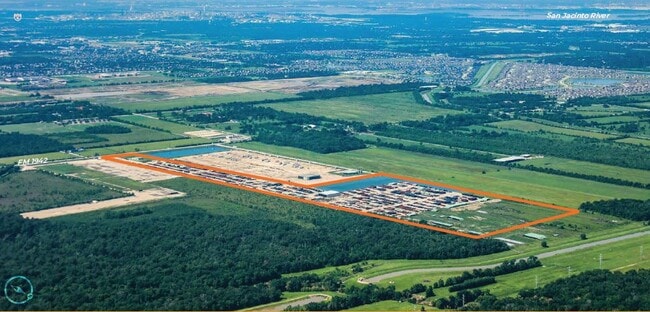
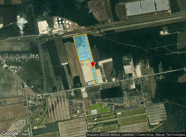
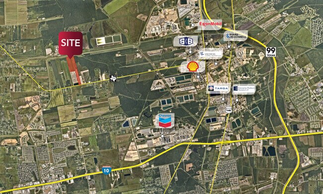
6421 Fm 1942 Rd, Baytown, TX 77521
NEARBY LISTINGS FOR SALE OR LEASE
-
-
View all Baytown listings for lease on LoopNet.com
Property Detail
6421 Fm 1942 Rd
0410100010003
Abst 54 H Nash
Outdoorrecreationbeachmountaindesert
TRS 3 & 4 ABST 54 H NASH
AE
Harris
48201C0755M
Texas
2024
83.46 AC
2025
Northeast Hwy 321
252800
Houston
20,853 SF
Houston-The Woodlands-Sugar Land, TX
DEMOGRAPHICS near 6421 Fm 1942 Rd
1 Mile
3 Mile
5 Mile
2024 Total Population
206
13,889
36,106
2029 Population
230
14,910
38,476
Pop Growth 2024-2029
+ 11.65%
+ 7.35%
+ 6.56%
Average Age
35
33
35
2024 Total Households
60
4,006
11,591
HH Growth 2024-2029
+ 10.00%
+ 6.81%
+ 6.26%
Median Household Inc
$86,764
$94,491
$77,106
Avg Household Size
3.40
3.40
3.10
2024 Avg HH Vehicles
3.00
2.00
2.00
Median Home Value
$278,571
$241,470
$220,684
Median Year Built
2010
2010
2003
Nearby Places
Map Layers
Map Styles
 Street
 Aerial
- Restaurants
- Banks
- Shops
- Fitness
- Groceries
PUBLIC TRANSPORTATION
AIRPORT
George Bush Intcntl/Houston
DRIVE
WALK
Distance
George Bush Intcntl/Houston
49 min
33.4 mi
William P Hobby
DRIVE
WALK
Distance
William P Hobby
55 min
33.8 mi
Freight Ports
Port of Houston
DRIVE
WALK
Distance
Port of Houston
41 min
25.8 mi
SALE & LEASE HISTORY
LISTING DATE
SALE/LEASE

Jun 27, 2024
For Lease
Jun 25, 2025
For Lease
Jun 25, 2025
For Sale
Jun 11, 2024
For Sale
Jan 18, 2023
For Sale
Nearby Properties
Address
Land Use
TOTAL SIZE
Lot Size
Zoning
Address
Land Use
TOTAL SIZE
Lot Size
Zoning
49.37 AC
Address
Land Use
TOTAL SIZE
Lot Size
Zoning
Address
Land Use
TOTAL SIZE
Lot Size
Zoning
59.21 AC
Address
Land Use
TOTAL SIZE
Lot Size
Zoning
956.90 AC
Address
Land Use
TOTAL SIZE
Lot Size
Zoning
138,240 SF
2.95 AC
Address
Land Use
TOTAL SIZE
Lot Size
Zoning
44,652 SF
12.33 AC
Address
Land Use
TOTAL SIZE
Lot Size
Zoning
59,580 SF
4.10 AC
Address
Land Use
TOTAL SIZE
Lot Size
Zoning
76,536 SF
2.72 AC
Address
Land Use
TOTAL SIZE
Lot Size
Zoning
58,626 SF
2.39 AC
Address
Land Use
TOTAL SIZE
Lot Size
Zoning
104.53 AC
Address
Land Use
TOTAL SIZE
Lot Size
Zoning
115.77 AC
Address
Land Use
TOTAL SIZE
Lot Size
Zoning
130.24 AC
Address
Land Use
TOTAL SIZE
Lot Size
Zoning
154.79 AC
Address
Land Use
TOTAL SIZE
Lot Size
Zoning
186.15 AC
Address
Land Use
TOTAL SIZE
Lot Size
Zoning
179.91 AC
Address
Land Use
TOTAL SIZE
Lot Size
Zoning
135.73 AC
Address
Land Use
TOTAL SIZE
Lot Size
Zoning
153 AC
Address
Land Use
TOTAL SIZE
Lot Size
Zoning
61.71 AC
Address
Land Use
TOTAL SIZE
Lot Size
Zoning
119.06 AC
Address
Land Use
TOTAL SIZE
Lot Size
Zoning
8,878 SF
7.04 AC
Address
Land Use
TOTAL SIZE
Lot Size
Zoning
Address
Land Use
TOTAL SIZE
Lot Size
Zoning
36,908 SF
10 AC
Address
Land Use
TOTAL SIZE
Lot Size
Zoning
76.90 AC
Address
Land Use
TOTAL SIZE
Lot Size
Zoning
23,862 SF
2.95 AC
Address
Land Use
TOTAL SIZE
Lot Size
Zoning
30,000 SF
128.90 AC
Address
Land Use
TOTAL SIZE
Lot Size
Zoning
21,020 SF
42.11 AC
Address
Land Use
TOTAL SIZE
Lot Size
Zoning
23,658 SF
2.92 AC
Address
Land Use
TOTAL SIZE
Lot Size
Zoning
70,650 SF
4.18 AC
Address
Land Use
TOTAL SIZE
Lot Size
Zoning
69.95 AC
The World's #1 Commercial Real Estate Marketplace
Connect with us
© 2026 CoStar Group
The information above has been obtained from sources believed reliable. While we do not doubt its accuracy we have not verified it and make no guarantee, warranty or representation about it. It is your responsibility to independently confirm its accuracy and completeness. Any projections, opinions, assumptions, or estimates used are for example only and do not represent the current or future performance of the property. The value of this transaction to you depends on tax and other factors which should be evaluated by your tax, financial, and legal advisors. You and your advisors should conduct a careful, independent investigation of the property to determine to your satisfaction the suitability of the property for your needs.