Property Record
6421 Monclova Rd, Maumee, OH 43537
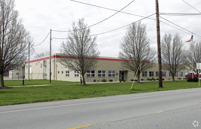

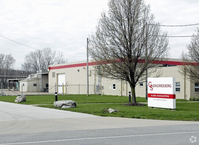
Property Detail
6421 Monclova Rd
38-01201
1 3 SW 1/4 W 220 FT E 1768.92 FT PT WOF WABASH RR & N LIN
Warehouse
Lucas
17-M2
Ohio
B and X Area of moderate flood hazard, usually the area between the limits of the 100-year and 500-year floods.
32,33
0
2.82 AC
2025
South/Southwest
009003
Toledo
28,834 SF
Toledo, OH
NEARBY LISTINGS FOR SALE OR LEASE
DEMOGRAPHICS near 6421 Monclova Rd
1 mile
3 mile
5 mile
2025 Total Population
2,326
34,592
101,261
2030 Population
2,295
34,257
100,551
Pop Growth 2025-2030
(1.33%)
(0.97%)
(0.70%)
Average Age
53
42
42
2025 Total Households
1,119
14,069
42,462
HH Growth 2025-2030
(1.25%)
(1.03%)
(0.76%)
Median Household Inc
$91,186
$106,015
$87,497
Avg Household Size
2.00
2.40
2.30
2025 Avg HH Vehicles
2.00
2.00
2.00
Median Home Value
$302,545
$323,956
$275,106
Median Year Built
2007
1987
1979
Nearby Places
Map Layers
Map Styles
 Street
 Aerial
Transit
 Traffic
 Biking
Places
Listings with unknown addresses are not visible on the map
- Restaurants
- Banks
- Shops
- Fitness
- Groceries
PUBLIC TRANSPORTATION
AIRPORT
Eugene F Kranz Toledo Express
Drive
Walk
Distance
Eugene F Kranz Toledo Express
21 min
9.3 mi
Freight Ports
Drive
Walk
Distance
29 min
16.4 mi
Nearby Properties
Address
Land Use
TOTAL SIZE
Lot Size
Zoning
Address
Land Use
TOTAL SIZE
Lot Size
Zoning
541,518 SF
21.30 AC
16-R1
Address
Land Use
TOTAL SIZE
Lot Size
Zoning
275,990 SF
49.65 AC
16-CM
Address
Land Use
TOTAL SIZE
Lot Size
Zoning
183,376 SF
16.04 AC
Address
Land Use
TOTAL SIZE
Lot Size
Zoning
67,264 SF
6.95 AC
16-CM
Address
Land Use
TOTAL SIZE
Lot Size
Zoning
35.94 AC
17-C3
Address
Land Use
TOTAL SIZE
Lot Size
Zoning
231,756 SF
31.37 AC
16-M1
Address
Land Use
TOTAL SIZE
Lot Size
Zoning
606,883 SF
119.87 AC
16-M2
Address
Land Use
TOTAL SIZE
Lot Size
Zoning
352,382 SF
62.93 AC
16-M1
Address
Land Use
TOTAL SIZE
Lot Size
Zoning
337,990 SF
17.75 AC
16-M1
Address
Land Use
TOTAL SIZE
Lot Size
Zoning
8.57 AC
16-M1
Address
Land Use
TOTAL SIZE
Lot Size
Zoning
608,280 SF
48.86 AC
16-M2
Address
Land Use
TOTAL SIZE
Lot Size
Zoning
212,672 SF
15.98 AC
17-R1
Address
Land Use
TOTAL SIZE
Lot Size
Zoning
350,408 SF
20.83 AC
17-M2
Address
Land Use
TOTAL SIZE
Lot Size
Zoning
214,986 SF
17.55 AC
19-R1
Address
Land Use
TOTAL SIZE
Lot Size
Zoning
119.87 AC
16-M2
Address
Land Use
TOTAL SIZE
Lot Size
Zoning
78,166 SF
2.08 AC
16-CM
Address
Land Use
TOTAL SIZE
Lot Size
Zoning
104,314 SF
15.43 AC
16-M2
Address
Land Use
TOTAL SIZE
Lot Size
Zoning
32.75 AC
16-M2
Address
Land Use
TOTAL SIZE
Lot Size
Zoning
86,450 SF
6.33 AC
17-R3
Address
Land Use
TOTAL SIZE
Lot Size
Zoning
262,764 SF
30.39 AC
17-M1
Address
Land Use
TOTAL SIZE
Lot Size
Zoning
55,124 SF
0.12 AC
16-C3
Address
Land Use
TOTAL SIZE
Lot Size
Zoning
3.12 AC
16-CM
Address
Land Use
TOTAL SIZE
Lot Size
Zoning
69,707 SF
9.36 AC
17-RA
Address
Land Use
TOTAL SIZE
Lot Size
Zoning
93,531 SF
13.31 AC
16-C2
Address
Land Use
TOTAL SIZE
Lot Size
Zoning
48,640 SF
10.98 AC
17-R1
Address
Land Use
TOTAL SIZE
Lot Size
Zoning
74,276 SF
13.08 AC
Address
Land Use
TOTAL SIZE
Lot Size
Zoning
128,249 SF
55.62 AC
17-MX
Address
Land Use
TOTAL SIZE
Lot Size
Zoning
133,079 SF
15.45 AC
10-CR
Address
Land Use
TOTAL SIZE
Lot Size
Zoning
114,721 SF
29.03 AC
17-AR
Address
Land Use
TOTAL SIZE
Lot Size
Zoning
198,187 SF
11.58 AC
10-RM36
The World's #1 Commercial Real Estate Marketplace
Connect with us
© 2026 CoStar Group
The information above has been obtained from sources believed reliable. While we do not doubt its accuracy we have not verified it and make no guarantee, warranty or representation about it. It is your responsibility to independently confirm its accuracy and completeness. Any projections, opinions, assumptions, or estimates used are for example only and do not represent the current or future performance of the property. The value of this transaction to you depends on tax and other factors which should be evaluated by your tax, financial, and legal advisors. You and your advisors should conduct a careful, independent investigation of the property to determine to your satisfaction the suitability of the property for your needs.