Property Record
6425 Route 209, Kerhonkson, NY 12446
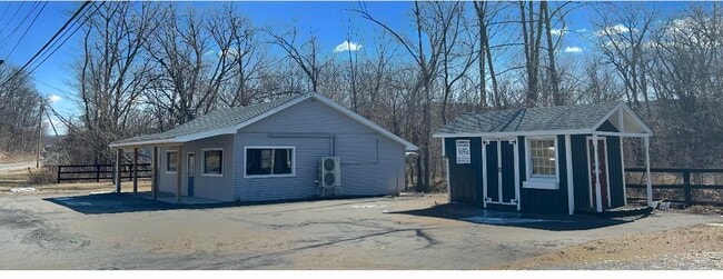
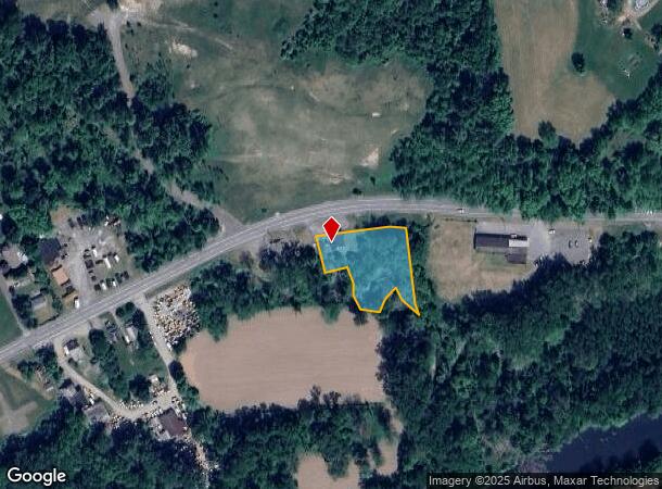
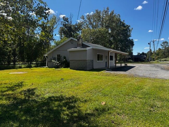
This Property Is For Sale
NEARBY LISTINGS FOR SALE OR LEASE
Property Detail
6425 Route 209
5689-076.013-0007-010.000-0000
Ulster
Storesoffices
New York
AE
10.000
36111C0570F
0.75 AC
2025
Hudson Valley Area
2024
Other Market Areas
954500
Kingston, NY
1,020 SF
DEMOGRAPHICS near 6425 Route 209
1 Mile
3 Mile
5 Mile
2024 Total Population
1,297
5,412
9,700
2029 Population
1,306
5,460
9,784
Pop Growth 2024-2029
+ 0.69%
+ 0.89%
+ 0.87%
Average Age
40
43
43
2024 Total Households
508
1,693
3,428
HH Growth 2024-2029
+ 0.79%
+ 1.12%
+ 1.02%
Median Household Inc
$60,551
$68,876
$67,926
Avg Household Size
2.40
2.40
2.40
2024 Avg HH Vehicles
2.00
2.00
2.00
Median Home Value
$245,833
$272,689
$283,448
Median Year Built
1953
1967
1968
Nearby Places
- Restaurants
- Banks
- Shops
- Fitness
- Groceries
PUBLIC TRANSPORTATION
AIRPORT
New York Stewart International
DRIVE
WALK
Distance
New York Stewart International
55 min
36.5 mi
Nearby Properties
Address
Land Use
TOTAL SIZE
Lot Size
Zoning
Address
Land Use
TOTAL SIZE
Lot Size
Zoning
67.16 AC
AR3
Address
Land Use
TOTAL SIZE
Lot Size
Zoning
2,970.01 AC
R5
Address
Land Use
TOTAL SIZE
Lot Size
Zoning
34,000 SF
369.80 AC
R5
Address
Land Use
TOTAL SIZE
Lot Size
Zoning
41,876 SF
8 AC
RV15
Address
Land Use
TOTAL SIZE
Lot Size
Zoning
17,749 SF
128.60 AC
RP
Address
Land Use
TOTAL SIZE
Lot Size
Zoning
15,456 SF
62.40 AC
B
Address
Land Use
TOTAL SIZE
Lot Size
Zoning
1,520 SF
49 AC
R5
Address
Land Use
TOTAL SIZE
Lot Size
Zoning
5.80 AC
RR40
Address
Land Use
TOTAL SIZE
Lot Size
Zoning
1,229.61 AC
RC3AC
Address
Land Use
TOTAL SIZE
Lot Size
Zoning
22,528 SF
117.60 AC
AR3
Address
Land Use
TOTAL SIZE
Lot Size
Zoning
12,615 SF
1 AC
IL
Address
Land Use
TOTAL SIZE
Lot Size
Zoning
1,440 SF
18.90 AC
AR3
Address
Land Use
TOTAL SIZE
Lot Size
Zoning
42,660 SF
3.30 AC
MU
Address
Land Use
TOTAL SIZE
Lot Size
Zoning
8,764 SF
1.43 AC
MU
Address
Land Use
TOTAL SIZE
Lot Size
Zoning
4,372 SF
12.50 AC
AR3
Address
Land Use
TOTAL SIZE
Lot Size
Zoning
145.50 AC
RS20
Address
Land Use
TOTAL SIZE
Lot Size
Zoning
7,819 SF
3.60 AC
RS20
Address
Land Use
TOTAL SIZE
Lot Size
Zoning
8,645 SF
9 AC
RU
Address
Land Use
TOTAL SIZE
Lot Size
Zoning
3,000 SF
2.80 AC
B
Address
Land Use
TOTAL SIZE
Lot Size
Zoning
60,000 SF
6 AC
AR3
Address
Land Use
TOTAL SIZE
Lot Size
Zoning
3,940 SF
6 AC
AR3
Address
Land Use
TOTAL SIZE
Lot Size
Zoning
7,680 SF
0.85 AC
RV15
Address
Land Use
TOTAL SIZE
Lot Size
Zoning
4,980 SF
25.10 AC
AR3
Address
Land Use
TOTAL SIZE
Lot Size
Zoning
6,900 SF
4.90 AC
B
Address
Land Use
TOTAL SIZE
Lot Size
Zoning
3,456 SF
2.30 AC
MU
Address
Land Use
TOTAL SIZE
Lot Size
Zoning
9,916 SF
3.40 AC
B
Address
Land Use
TOTAL SIZE
Lot Size
Zoning
2,968 SF
70.40 AC
R5
Address
Land Use
TOTAL SIZE
Lot Size
Zoning
5,140 SF
4.20 AC
RS20
Address
Land Use
TOTAL SIZE
Lot Size
Zoning
60.19 AC
RS20
Address
Land Use
TOTAL SIZE
Lot Size
Zoning
2,720 SF
15.40 AC
B
The World's #1 Commercial Real Estate Marketplace
Connect with us
© 2025 CoStar Group
The information above has been obtained from sources believed reliable. While we do not doubt its accuracy we have not verified it and make no guarantee, warranty or representation about it. It is your responsibility to independently confirm its accuracy and completeness. Any projections, opinions, assumptions, or estimates used are for example only and do not represent the current or future performance of the property. The value of this transaction to you depends on tax and other factors which should be evaluated by your tax, financial, and legal advisors. You and your advisors should conduct a careful, independent investigation of the property to determine to your satisfaction the suitability of the property for your needs.