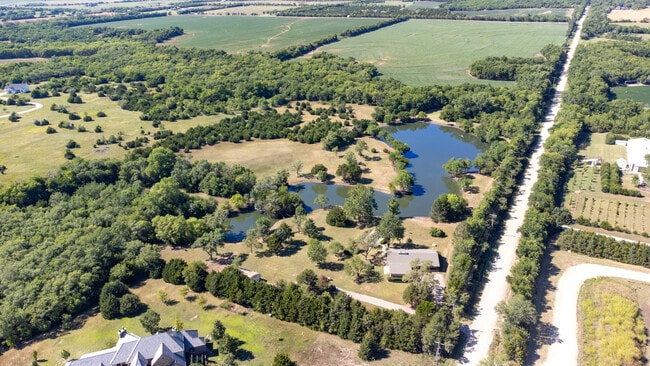
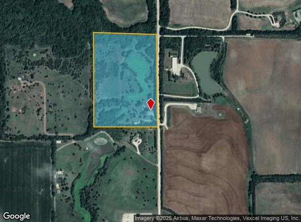
Property Record
6427 N 143Rd St E, Wichita, KS 67228

NEARBY LISTINGS FOR SALE OR LEASE
Property Detail
6427 N 143Rd St E
101-11-0-41-00-001.00
Original Town Now City Of Wichita
Farms
BEG NE COR SE1/4 S 1160 FT W 829 FTN 1160 FT E 829 FT TO BEG SEC 11-26-2E
A
Sedgwick
20173C0245G
Kansas
2024
0.83 AC
2025
NE Sedgwick County
010116
Wichita
3,114 SF
Wichita, KS
DEMOGRAPHICS near 6427 N 143Rd St E
1 Mile
3 Mile
5 Mile
2024 Total Population
15
629
9,637
2029 Population
15
638
9,837
Pop Growth 2024-2029
0.00%
+ 1.43%
+ 2.08%
Average Age
37
38
38
2024 Total Households
5
227
3,444
HH Growth 2024-2029
0.00%
+ 1.32%
+ 2.03%
Median Household Inc
$118,749
$91,304
$102,614
Avg Household Size
2.40
2.80
2.70
2024 Avg HH Vehicles
3.00
2.00
2.00
Median Home Value
$299,999
$299,073
$288,079
Median Year Built
1999
1999
2004
Nearby Places
Map Layers
Map Styles
 Street
 Aerial
- Restaurants
- Banks
- Shops
- Fitness
- Groceries
PUBLIC TRANSPORTATION
AIRPORT
Wichita Dwight D Eisenhower Ntl
DRIVE
WALK
Distance
Wichita Dwight D Eisenhower Ntl
31 min
21.4 mi
SALE & LEASE HISTORY
LISTING DATE
SALE/LEASE

Sep 07, 2022
For Sale
Nearby Properties
Address
Land Use
TOTAL SIZE
Lot Size
Zoning
Address
Land Use
TOTAL SIZE
Lot Size
Zoning
184,788 SF
19.75 AC
M-1
Address
Land Use
TOTAL SIZE
Lot Size
Zoning
176,000 SF
9.90 AC
M-1
Address
Land Use
TOTAL SIZE
Lot Size
Zoning
1,097 SF
243.81 AC
SF-5
Address
Land Use
TOTAL SIZE
Lot Size
Zoning
12.93 AC
MI
Address
Land Use
TOTAL SIZE
Lot Size
Zoning
2,400 SF
39.10 AC
Address
Land Use
TOTAL SIZE
Lot Size
Zoning
6,000 SF
9.32 AC
RR
Address
Land Use
TOTAL SIZE
Lot Size
Zoning
24,200 SF
55.87 AC
RR
Address
Land Use
TOTAL SIZE
Lot Size
Zoning
2,460 SF
6.47 AC
RR
Address
Land Use
TOTAL SIZE
Lot Size
Zoning
12,629 SF
0.94 AC
RR
Address
Land Use
TOTAL SIZE
Lot Size
Zoning
9,410 SF
1.96 AC
RR
Address
Land Use
TOTAL SIZE
Lot Size
Zoning
8,556 SF
1.98 AC
RR
Address
Land Use
TOTAL SIZE
Lot Size
Zoning
6,984 SF
1.09 AC
RR
Address
Land Use
TOTAL SIZE
Lot Size
Zoning
8,611 SF
1.69 AC
RR
Address
Land Use
TOTAL SIZE
Lot Size
Zoning
7,150 SF
6.04 AC
GC
Address
Land Use
TOTAL SIZE
Lot Size
Zoning
5,354 SF
0.87 AC
RR
Address
Land Use
TOTAL SIZE
Lot Size
Zoning
6,419 SF
0.99 AC
RR
Address
Land Use
TOTAL SIZE
Lot Size
Zoning
10,888 SF
1.49 AC
RR
Address
Land Use
TOTAL SIZE
Lot Size
Zoning
1.70 AC
Address
Land Use
TOTAL SIZE
Lot Size
Zoning
6,764 SF
3.34 AC
RR
Address
Land Use
TOTAL SIZE
Lot Size
Zoning
8,236 SF
2.01 AC
RR
Address
Land Use
TOTAL SIZE
Lot Size
Zoning
6,090 SF
2.22 AC
RR
Address
Land Use
TOTAL SIZE
Lot Size
Zoning
5,521 SF
10.86 AC
RR
Address
Land Use
TOTAL SIZE
Lot Size
Zoning
6,453 SF
1.10 AC
RR
Address
Land Use
TOTAL SIZE
Lot Size
Zoning
6,336 SF
1.86 AC
RR
Address
Land Use
TOTAL SIZE
Lot Size
Zoning
5,880 SF
1.44 AC
RR
Address
Land Use
TOTAL SIZE
Lot Size
Zoning
11,415 SF
1.73 AC
RR
Address
Land Use
TOTAL SIZE
Lot Size
Zoning
6,405 SF
0.59 AC
RR
Address
Land Use
TOTAL SIZE
Lot Size
Zoning
4,175 SF
1.24 AC
RR
Address
Land Use
TOTAL SIZE
Lot Size
Zoning
8,012 SF
1.24 AC
RR
The World's #1 Commercial Real Estate Marketplace
Connect with us
© 2026 CoStar Group
The information above has been obtained from sources believed reliable. While we do not doubt its accuracy we have not verified it and make no guarantee, warranty or representation about it. It is your responsibility to independently confirm its accuracy and completeness. Any projections, opinions, assumptions, or estimates used are for example only and do not represent the current or future performance of the property. The value of this transaction to you depends on tax and other factors which should be evaluated by your tax, financial, and legal advisors. You and your advisors should conduct a careful, independent investigation of the property to determine to your satisfaction the suitability of the property for your needs.