Property Record
643 Main St, Blackshear, GA 31516


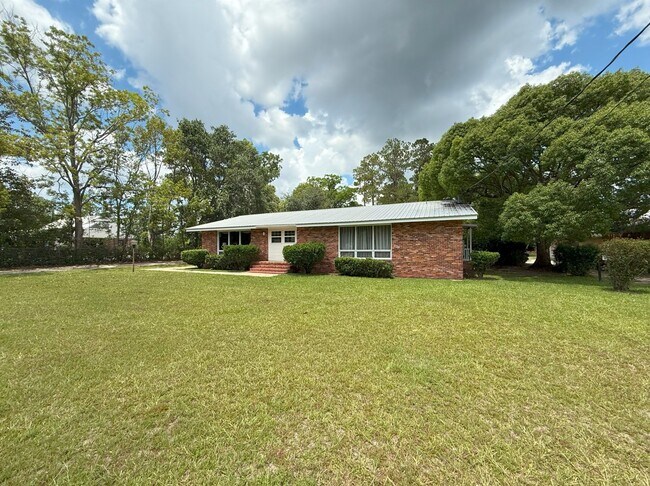
Property Detail
643 Main St
B10-049
LL92 LD9
Medicalbuilding
PIERCE
NC
Georgia
B and X Area of moderate flood hazard, usually the area between the limits of the 100-year and 500-year floods.
0.97 AC
2025
Georgia South Area
2025
Other Market Areas
960402
Waycross, GA
1,981 SF
NEARBY LISTINGS FOR SALE OR LEASE
-
-
View all Blackshear listings for sale on LoopNet.com
DEMOGRAPHICS near 643 Main St
1 mile
3 mile
5 mile
2025 Total Population
2,684
6,844
11,749
2030 Population
2,775
7,093
12,184
Pop Growth 2025-2030
+ 3.39%
+ 3.64%
+ 3.70%
Average Age
42
41
41
2025 Total Households
1,065
2,706
4,547
HH Growth 2025-2030
+ 3.38%
+ 3.55%
+ 3.69%
Median Household Inc
$44,230
$46,920
$53,735
Avg Household Size
2.40
2.40
2.50
2025 Avg HH Vehicles
2.00
2.00
2.00
Median Home Value
$170,216
$168,074
$158,266
Median Year Built
1981
1982
1987
Nearby Places
Map Layers
Map Styles
 Street
 Aerial
Transit
 Traffic
 Biking
Places
Listings with unknown addresses are not visible on the map
- Restaurants
- Banks
- Shops
- Fitness
- Groceries
SALE & LEASE HISTORY
LISTING DATE
SALE/LEASE

Jul 16, 2025
For Sale
Nearby Properties
Address
Land Use
TOTAL SIZE
Lot Size
Zoning
Address
Land Use
TOTAL SIZE
Lot Size
Zoning
15,818 SF
2.80 AC
PI
Address
Land Use
TOTAL SIZE
Lot Size
Zoning
51,640 SF
17.20 AC
I
Address
Land Use
TOTAL SIZE
Lot Size
Zoning
42,835 SF
4.15 AC
P/I
Address
Land Use
TOTAL SIZE
Lot Size
Zoning
24,500 SF
6.67 AC
C
Address
Land Use
TOTAL SIZE
Lot Size
Zoning
24,684 SF
4.90 AC
C
Address
Land Use
TOTAL SIZE
Lot Size
Zoning
3,294 SF
10.56 AC
SF
Address
Land Use
TOTAL SIZE
Lot Size
Zoning
26,391 SF
6.49 AC
C
Address
Land Use
TOTAL SIZE
Lot Size
Zoning
56,460 SF
6.65 AC
C
Address
Land Use
TOTAL SIZE
Lot Size
Zoning
47,616 SF
7.22 AC
MF
Address
Land Use
TOTAL SIZE
Lot Size
Zoning
32,472 SF
2.18 AC
C
Address
Land Use
TOTAL SIZE
Lot Size
Zoning
300.57 AC
I
Address
Land Use
TOTAL SIZE
Lot Size
Zoning
2,523 SF
70.28 AC
I
Address
Land Use
TOTAL SIZE
Lot Size
Zoning
140,000 SF
14.78 AC
LI
Address
Land Use
TOTAL SIZE
Lot Size
Zoning
51,640 SF
17.20 AC
I
Address
Land Use
TOTAL SIZE
Lot Size
Zoning
3,600 SF
5.45 AC
NC
Address
Land Use
TOTAL SIZE
Lot Size
Zoning
32,940 SF
4.60 AC
C
Address
Land Use
TOTAL SIZE
Lot Size
Zoning
38,756 SF
8.22 AC
I
Address
Land Use
TOTAL SIZE
Lot Size
Zoning
1,400 SF
13 AC
C
Address
Land Use
TOTAL SIZE
Lot Size
Zoning
5.48 AC
SF
Address
Land Use
TOTAL SIZE
Lot Size
Zoning
11,192 SF
1.14 AC
C
Address
Land Use
TOTAL SIZE
Lot Size
Zoning
2,772 SF
5 AC
MF
Address
Land Use
TOTAL SIZE
Lot Size
Zoning
11,252 SF
5.22 AC
MF
Address
Land Use
TOTAL SIZE
Lot Size
Zoning
4,800 SF
1.64 AC
C
Address
Land Use
TOTAL SIZE
Lot Size
Zoning
10,552 SF
2.68 AC
C
Address
Land Use
TOTAL SIZE
Lot Size
Zoning
4,758 SF
16.24 AC
C
Address
Land Use
TOTAL SIZE
Lot Size
Zoning
8,640 SF
3.86 AC
C
Address
Land Use
TOTAL SIZE
Lot Size
Zoning
1 SF
10.32 AC
SF
Address
Land Use
TOTAL SIZE
Lot Size
Zoning
20,530 SF
3.16 AC
C
Address
Land Use
TOTAL SIZE
Lot Size
Zoning
12,500 SF
2.36 AC
C
Address
Land Use
TOTAL SIZE
Lot Size
Zoning
7,685 SF
1.53 AC
NC
The World's #1 Commercial Real Estate Marketplace
Connect with us
© 2026 CoStar Group
The information above has been obtained from sources believed reliable. While we do not doubt its accuracy we have not verified it and make no guarantee, warranty or representation about it. It is your responsibility to independently confirm its accuracy and completeness. Any projections, opinions, assumptions, or estimates used are for example only and do not represent the current or future performance of the property. The value of this transaction to you depends on tax and other factors which should be evaluated by your tax, financial, and legal advisors. You and your advisors should conduct a careful, independent investigation of the property to determine to your satisfaction the suitability of the property for your needs.