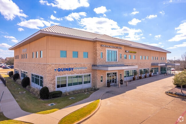
Property Record
6435 S Fm 549, Rockwall, TX 75032


Current Lease Availabilities
Property Detail
6435 S Fm 549
Dallas-Fort Worth-Arlington, TX
BAYLOR MEDICAL CENTER, BLOCK A, LOT 1, ACRES 4.79
61705
Rockwall
Commercialnec
Texas
B and X Area of moderate flood hazard, usually the area between the limits of the 100-year and 500-year floods.
1
2024
4.79 AC
2025
Rockwall
040508
Dallas/Ft Worth
36,633 SF
NEARBY LISTINGS FOR SALE OR LEASE
-
-
View all Rockwall listings for lease on LoopNet.com
DEMOGRAPHICS near 6435 S Fm 549
1 mile
3 mile
5 mile
2025 Total Population
2,092
32,267
69,539
2030 Population
2,490
38,515
83,811
Pop Growth 2025-2030
+ 19.02%
+ 19.36%
+ 20.52%
Average Age
41
40
39
2025 Total Households
694
10,922
24,608
HH Growth 2025-2030
+ 18.73%
+ 19.29%
+ 19.88%
Median Household Inc
$161,012
$107,517
$99,761
Avg Household Size
3.00
2.90
2.70
2025 Avg HH Vehicles
3.00
3.00
2.00
Median Home Value
$722,612
$477,055
$431,056
Median Year Built
2004
2004
2005
Nearby Places
Map Layers
Map Styles
 Street
 Aerial
Layers
 Traffic
 Biking
Places
Listings with unknown addresses are not visible on the map
- Restaurants
- Banks
- Shops
- Fitness
- Groceries
PUBLIC TRANSPORTATION
AIRPORT
Dallas Love Field
Drive
Walk
Distance
Dallas Love Field
44 min
28.8 mi
Dallas-Fort Worth International
Drive
Walk
Distance
Dallas-Fort Worth International
56 min
45.5 mi
Nearby Properties
Address
Land Use
TOTAL SIZE
Lot Size
Zoning
Address
Land Use
TOTAL SIZE
Lot Size
Zoning
326,761 SF
23.09 AC
Address
Land Use
TOTAL SIZE
Lot Size
Zoning
193,393 SF
80 AC
Address
Land Use
TOTAL SIZE
Lot Size
Zoning
326,408 SF
74.12 AC
Address
Land Use
TOTAL SIZE
Lot Size
Zoning
238,085 SF
34.49 AC
Address
Land Use
TOTAL SIZE
Lot Size
Zoning
413,908 SF
35.30 AC
Address
Land Use
TOTAL SIZE
Lot Size
Zoning
282,628 SF
4.03 AC
Address
Land Use
TOTAL SIZE
Lot Size
Zoning
157,834 SF
30.89 AC
Address
Land Use
TOTAL SIZE
Lot Size
Zoning
214,166 SF
21.42 AC
Address
Land Use
TOTAL SIZE
Lot Size
Zoning
198,270 SF
21.48 AC
Address
Land Use
TOTAL SIZE
Lot Size
Zoning
153,541 SF
27.44 AC
Address
Land Use
TOTAL SIZE
Lot Size
Zoning
77,891 SF
11.61 AC
A
Address
Land Use
TOTAL SIZE
Lot Size
Zoning
144,725 SF
12.89 AC
Address
Land Use
TOTAL SIZE
Lot Size
Zoning
227,296 SF
2.14 AC
Address
Land Use
TOTAL SIZE
Lot Size
Zoning
226,384 SF
36.03 AC
Address
Land Use
TOTAL SIZE
Lot Size
Zoning
196,981 SF
8.92 AC
Address
Land Use
TOTAL SIZE
Lot Size
Zoning
85,912 SF
5.93 AC
Address
Land Use
TOTAL SIZE
Lot Size
Zoning
174,826 SF
11.13 AC
Address
Land Use
TOTAL SIZE
Lot Size
Zoning
108,429 SF
2.06 AC
Address
Land Use
TOTAL SIZE
Lot Size
Zoning
99,800 SF
10.10 AC
C
Address
Land Use
TOTAL SIZE
Lot Size
Zoning
57,666 SF
1.31 AC
Address
Land Use
TOTAL SIZE
Lot Size
Zoning
57,303 SF
7.68 AC
Address
Land Use
TOTAL SIZE
Lot Size
Zoning
93,932 SF
10 AC
Address
Land Use
TOTAL SIZE
Lot Size
Zoning
202,607 SF
25.93 AC
Address
Land Use
TOTAL SIZE
Lot Size
Zoning
44,908 SF
1.03 AC
Address
Land Use
TOTAL SIZE
Lot Size
Zoning
74,900 SF
15.43 AC
Address
Land Use
TOTAL SIZE
Lot Size
Zoning
74,900 SF
12.56 AC
Address
Land Use
TOTAL SIZE
Lot Size
Zoning
121,888 SF
2.45 AC
Address
Land Use
TOTAL SIZE
Lot Size
Zoning
90,108 SF
8.72 AC
Address
Land Use
TOTAL SIZE
Lot Size
Zoning
67,511 SF
12.36 AC
The World's #1 Commercial Real Estate Marketplace
Connect with us
© 2026 CoStar Group
The information above has been obtained from sources believed reliable. While we do not doubt its accuracy we have not verified it and make no guarantee, warranty or representation about it. It is your responsibility to independently confirm its accuracy and completeness. Any projections, opinions, assumptions, or estimates used are for example only and do not represent the current or future performance of the property. The value of this transaction to you depends on tax and other factors which should be evaluated by your tax, financial, and legal advisors. You and your advisors should conduct a careful, independent investigation of the property to determine to your satisfaction the suitability of the property for your needs.